Agricultural Censuses run by Defra (Department for Environment, Food and Rural Affairs) and the devolved administrations collect annual information on the land-use of farms. Table 1.12 below shows the area of woodland on farms.
The area of farm woodland in the UK has increased from 0.7 million hectares in 2009 to 1.0 million hectares in 2018 (Table 1.12). Slightly over one half (52%) of all farm woodland was in Scotland in 2018, with a further 37% in England, 10% in Wales and the remaining 2% in Northern Ireland.
Table 1.12 Area of farm woodland, 2009-2018
| Year |
England |
Wales |
Scotland |
Northern Ireland |
UK |
| thousand hectares |
| 2009 |
303.7 |
60.8 |
350.8 |
10.3 |
725.7 |
| 2010 |
295.3 |
69.1 |
399.8 |
10.2 |
774.0 |
| 2011 |
304.9 |
44.2 |
426.1 |
10.8 |
785.9 |
| 2012 |
308.4 |
62.6 |
445.4 |
11.0 |
827.5 |
| 2013 |
324.9 |
63.4 |
466.8 |
10.3 |
865.4 |
| 2014 |
331.3 |
75.7 |
479.4 |
11.1 |
897.5 |
| 2015 |
347.6 |
78.0 |
524.0 |
11.1 |
960.6 |
| 2016 |
370.5 |
89.2 |
502.4 |
16.1 |
978.2 |
| 2017 |
368.5 |
92.8 |
560.1 |
15.8 |
1037.2 |
| 2018 |
371.7 |
96.8 |
531.5 |
16.3 |
1016.3 |
Source: June Agricultural Census – Defra, The Scottish Government, Welsh Government, Northern Ireland Executive.
Notes:
1. Changes in the area of farm woodland over time indicate a change in the area of farm land that is reported as woodland and do not necessarily indicate a change in woodland area.
Figure 1.5 Area of farm woodland, 1981-2018
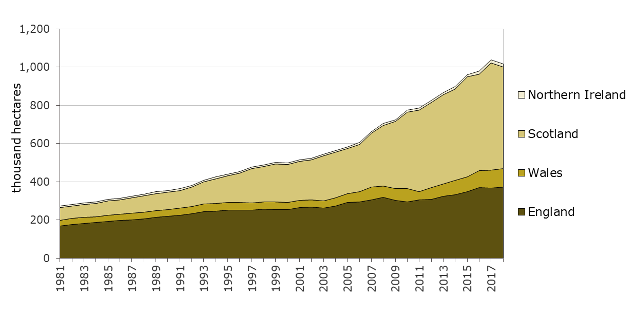
Source: June Agricultural Census – Defra, The Scottish Government, Welsh Government, Northern Ireland Executive.
Notes:
1. Changes in the area of farm woodland over time indicate a change in the area of farm land that is reported as woodland and do not necessarily indicate a change in woodland area.