Tools and Resources
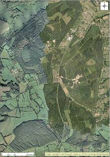
The Forest Research Alice Holt Research Station is located in the centre of the Forest (National Grid reference SU 813427). The Forest of some 850 hectares forms part of the South Downs National Park and straddles the Hampshire/Surrey county boundary.
Alice Holt Forest lies at the north western corner of the Weald where the bounding rim of Chalk swings round from a south-north trending outcrop to the west-east alignment of the Hog’s Back anticline. A subsidiary more gentle fold to the south of this anticline raises the Gault Clay to form high ground some 100 to 125 m OD. River terrace gravels have protected this clay from erosion during the Quaternary, so that it forms the main physiographic feature of the locality. The River Wey runs in a wide valley just outside the northern boundary of the forest, flowing north-east towards Farnham. Around the edge of the plateau, the ground falls steeply to north and west south west with convex slopes around 7to 11 degrees. Stream incision has caused local minor landslips where slopes are 12 to 18 degrees.
The climate is characteristic of south-east England, with an annual temperature range and a rainfall typical of inland south-central Britain. The 1971 to 2000 averages for Alice Holt of maximum, minimum and mean air temperature are 22.5, -0.5 and10 degrees C respectively. Mean annual rainfall (1971-2000) is 782 mm with a distinct July minimum, although February can be the driest month.
The bulk of the Forest is underlain by Gault Clay (Cretaceous) but two detached compartments to the west include the escarpment of the Cretaceous Upper Greensand, and the Research nursery at Headley is on Lower Greensand. Gravel deposits, mapped by the British Geological Survey as Plateau or High-Level Terrace Gravels mantle the high ground. Low-Level Terrace Gravels occur at lower elevations in parts of the Forest. Alluvium occurs along streams draining the Forest.
The soil types represented across Alice Holt forest include brown soils, podzolic soils, surface-water gley soils and groundwater gley soils according to the Soil Survey of England and Wales classification of major soil groups. According to the FAO/UNESCO scheme, Major Groups of Fluvisols, Gleysols, Cambisols, Luvisols, Podzols and Planosols are represented.
The range of conifer species represented across Alice Holt forest is shown in the table below, although for broadleaf species, the list is restricted to oak and mixed broadleaves. The value of Alice Holt to research into broadleaf woodland is the large old-growth component (~200 years old), complemented by a range of younger stands planted between 1930 and 1995.
| Scientific name | Area (ha) | ||
|---|---|---|---|
| Broadleaf | Oak | Quercus robur, Q. petraea | 271 |
| Beech | Fagus sylvatica | 19 | |
| Birch | Betula pendula | 23 | |
| Ash | Fraxinus excelsior | 9 | |
| Sweet chestnut | Castanea sativa | 4 | |
| Mixed/others | 50 | ||
| Total broadleaved | 376 | ||
| Conifer | Corsican pine | Pinus nigra var. maritima | 184 |
| Scots pine | Pinus sylvestris | 43 | |
| Norway spruce | Picea abies | 22 | |
| Western hemlock | Tsuga heterophylla | 25 | |
| Larch | Larix spp. | 20 | |
| Douglas fir | Pseudotsuga menziesii | 25 | |
| Cypress | Cupressus spp. | 6 | |
| Western Red cedar | Thuja plicata | 7 | |
| Mixed/others | 2 | ||
| Total conifer | 338 | ||
| Total | 714 | ||
Alice Holt Forest probably originated in the Atlantic Period (5500 B.C. to 2600 B.C.) with pedunculate oak emerging as the main tree species.
Man has lived in the forest since Lower Palaeolithic times. Finds of Mesolithic and Neolithic flints and Bronze Age relics testify to man’s association with the forest. During Roman times Alice holt was part of the Forest of Anderida and the Gault Clay below the forest together with the oak woods above were used by the Romans for the making of pottery. During the Anglo Saxon period, the forest was state owned, but in Saxon times, some of the woodland was felled, resulting in remaining woodland becoming sanctuary for deer and other wildlife. Gradually, these became favoured for game and were acquired by individual owners. However, after the Norman conquest, the forest reverted to the Crown and was valued as a Royal hunting ground or “chase”. Alice Holt and nearby Woolmer forests are relics of the original royal chase forests. The others in Hampshire being the New Forest and Bere Forest.
Considerable exploitation of oak timber in the 18th Century to support the British navy left the forest in a poor state but in 1812 the forest was enclosed and replanting took place. Alice Holt Forest was acquired by the Forestry Commission in 1924, and a Research Station set up there in 1946 Conifers were introduced to the Forest in the latter part of the 19th Century following the poor growth of the oak on the areas of gravel soils, the proportion of conifers increased during the 20th Century but the current practice of plantations on ancient woodland sites (PAWS) restoration will see 450 ha of conifer returned to native woodland.