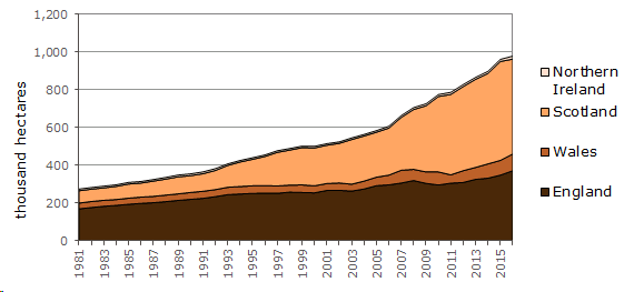
Agricultural Censuses run by Defra (Department for Environment, Food and Rural Affairs) and the devolved administrations collect annual information on the land-use of farms. Table 1.12 below shows the area of woodland on farms.
The area of farm woodland in the UK has increased from 663 thousand hectares in 2007 to 978 thousand hectares in 2016 (Table 1.12). Around one half (51%) of all farm woodland was in Scotland in 2016, with a further 38% in England, 9% in Wales and the remaining 2% in Northern Ireland.
Table 1.12 Area of farm woodland, 2007-2016
| Year | England | Wales | Scotland | Northern Ireland | UK |
| thousand hectares | |||||
| 2007 | 305.4 | 67.9 | 279.9 | 9.9 | 663.1 |
| 2008 | 318.8 | 59.2 | 317.3 | 9.9 | 705.3 |
| 2009 | 303.7 | 60.8 | 350.8 | 10.3 | 725.7 |
| 2010 | 295.3 | 69.1 | 399.8 | 10.2 | 774.0 |
| 2011 | 304.9 | 44.2 | 426.1 | 10.8 | 785.9 |
| 2012 | 308.4 | 62.6 | 445.4 | 11.0 | 827.5 |
| 2013 | 324.9 | 63.4 | 466.8 | 10.3 | 865.4 |
| 2014 | 331.3 | 75.7 | 479.4 | 11.1 | 897.5 |
| 2015 | 347.6 | 78.0 | 524.0 | 11.1 | 960.6 |
| 2016 | 370.5 | 89.2 | 502.4 | 16.1 | 978.2 |
Source: June Agricultural Census – Defra, The Scottish Government, Welsh Government, Northern Ireland Executive.
Figure 1.5 Area of farm woodland, 1981-2016
Source: June Agricultural Census – Defra, The Scottish Government, Welsh Government, Northern Ireland Executive.