Research
Habitat networks
Research Status:completed
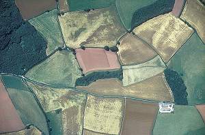
Despite considerable conservation effort at a site-based scale, research and monitoring has revealed the continuing decline of biodiversity. The decline is thought to be due to the effects of habitat fragmentation and a reduction in habitat quality, caused by edge effects associated with intensive land management. Habitat networks are intended to reverse this decline by linking and expanding habitats which are capable of sustaining a greater biodiversity.
There is potential for the creation of networks for most habitats and species.
Frequently asked questions about habitat networks
Initially, we have focussed on the recognition and development of forest and woodland habitat networks (FHN), as these have considerable biodiversity interest, and have undergone extreme fragmentation. In developing FHNs we have also recognised the need to consider non-woodland habitat and species, to avoid further fragmentation.
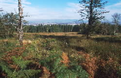
Recent work on Lowland Habitat Networks (LHN) has turned to open ground habitats.
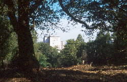
Further research is now concentrating on an approach which will incorporate the development of an Integrated Habitat Network that will increase biodiversity in all habitats whilst providing valuable greenspace links for people.
The habitat network (HN) programme includes projects linked by the application of the BEETLE (Biological and Environmental Evaluation Tools for Landscape Ecology) suite of tools, developed within the Landscape Ecology programme. Each project has a common aim, to develop a HN which will be used to plan habitat and species protection, management, restoration and expansion at a landscape scale, with respect to other biodiversity interests. The work is underpinned by landscape ecology theory, in particular, island biogeography theory and metapopulation dynamics.
The projects are:
This programme has evolved in synergy with the scientific principles developed in the Landscape Ecology programme. The approach has been to use the Forest Research Habitat Network tool (based on an accumulated cost distance buffer model) to test the functional connectivity of woodland habitat for woodland focal species. This method is also used to assess the impact of land use change scenarios on key focal species of locally important open habitats.
Each project has a common aim: to developed a plan, in the form of a set of maps, to guide the strategic protection, management, restoration and expansion of woodland habitats.
This research programme is funded by:
Forestry Commission policy on FHNs originates from the Earth Summit in Rio in 1992, from which followed the Convention on Biological Diversity (1992) and the Resolution for the Conservation of Biodiversity in European Forests signed in Helsinki in 1993. In addition the UK Government developed the strategy “Biodiversity: the UK Action Plan” (UKBAP) and in 1995 published the UKBAP Species Action Plans, and Habitat Action Plans.
The Forestry Commission’s Forestry Strategy Documents for the devolved countries of England, Scotland and Wales outline the threat of biodiversity loss from habitat fragmentation. In particular, the strategies for Scotland and Wales stress the need for woodland expansion in the form of FHNs, to protect woodland biodiversity.
Evaluating Biodiversity in Fragmented Landscapes: Principles (PDF-488K)
Forestry Commission Information Note 073
Kevin Watts
Duncan Ray
Habitat fragmentation at a variety of scales has been widely linked with the decline of many species globally. Over recent decades there has been a recorded decline in the biodiversity of many semi-natural woodlands and open habitats despite protection through designation (SSSI and NNR). The long-term viability of woodland biodiversity, which evolved within a highly connected and extensive habitat, is threatened by fragmentation, as it leads to smaller and more isolated woodlands. Many ecologists advocate the maintenance and improvement of connectivity between fragmented woodland populations, with growing interest in the use of habitat networks to reverse the effects of fragmentation by expanding and linking isolated habitats.
Since the post glacial colonisation, Britain’s woodland, which is thought to have once covered over 75% of the land area, has been fragmented to such a degree that less than 5% remained by the beginning of the 19th Century. Afforestation throughout the 20th Century has increased woodland cover to 16.8 % in Scotland, 15% in Wales and 8% in England. However, the ancient semi-natural remnant woodlands remain largely fragmented: new plantations provide unfavourable habitat, and are spatially unconstrained; while the surrounding matrix is often intensively managed, remaining unsuitable for woodland species dispersal.
The concept of species conservation through habitat networks has developed rapidly since the signing of the Convention on Biological Diversity. This has prompted a new international acceptance and emerging agreement of the need to conserve biological diversity using an approach which includes the planning, establishment and adaptive management of protected-area networks.
At the international scale, following an agreement between 55 European countries in 1995, the Pan-European Ecological Network began a program to develop habitat networks based on data at a resolution of 1 km from the CORINE biotope database and the general soil type distribution in Europe. At the regional scale, habitat networks for wide-ranging species have been assessed in the design and planning of nature reserves and conservation.
In Britain, the concept of woodland expansion via FHNs has gained considerable support throughout the last decade largely from the efforts of George Peterken and policy outlined in the forestry strategy documents.
It is assumed that the development of FHNs will help reverse woodland fragmentation, and in particular reverse the fragmentation of ancient woodland habitat. Indeed it has been argued that this will maintain genetic contact both within and between meta-populations and, in turn, provide greater species resilience in times of external stress, such as climate change.
SSSI – Site of special scientific interest
NNR – National nature reserve
| Habitat networks | Generic focal species | Networks and change | Using the networks | Tools | Validation |
What is a habitat network?
A habitat network is a configuration of habitat that allows species to move and disperse through a landscape. Networks can be produced for a particular type of habitat. For example, a forest habitat network focuses on how woodland species utilise woodland habitat and disperse through this and other habitat types in the wider landscape.
What is classed as habitat?
Habitat is defined as the area of land cover where an organism or ecological community normally lives or occurs and is specific to each of the generic focal species being considered. For example, broadleaved woodland specialist habitat is derived from woodland data sets where the woodland type is broadleaved, within a minimum canopy cover. The woodland area classed as habitat may also be subject to a reduction in size due to the application of an internal buffer representing the edge effect.
What’s the difference between a forest habitat network and a habitat network for open ground species?
The principles for how forest species and open ground species use habitat networks are the same, but is defined by the type of habitat each is associated with. Hence an example of an open ground habitat network may be a heathland generalist, which uses heathland as habitat, rather than woodland.
The woodland network covers priority open ground habitat. Does this mean that the open ground has been changed/lost?
No, all networks represent the dispersal range of the generic focal species (GFS) being considered, rather than a physical change. Networks thus overlap a range of other habitats, and open ground networks are just as likely to overlap woodland habitat.
Why don’t broadleaved networks link to pine networks?
Broadleaved networks represent the functional connectivity of all types of broadleaved woodland and how species may move from one patch of broadleaved woodland to another. Although species specifically associated with broadleaved woodland may utilise some small elements of other land cover types, including pinewood, it is assumed they will find movement through these habitats more difficult. Consequently, broadleaved and pinewood networks are considered to operate independently and are not linked.
Why isn’t there a network around all the woodlands?
Woodlands that have little tree cover (less than 10% canopy cover), or are degraded or extensively managed (much farm and parkland woodland) are unlikely to possess the habitat attributes that many species require and were not considered as woodland habitat. Woodlands that are very narrow lack the ‘core woodland’ many species require, and this is represented in the modelling process by applying an internal buffer. Although these woodlands are not part of a network at present, they provide an excellent opportunity to improve the network by expanding their width.
Why isn’t a good (biodiversity) quality woodland I know about in a good (biodiversity) quality network?
The biodiversity quality of woodlands have been determined through interview (ancient pinewoods in Highland; mixed and broadleaved woodlands in the Borders, broadleaved woodlands in SW Scotland) or by using coincidence mapping (see Forest Habitat Networks Scotland – Borders and the Lothians report(PDF-2086K) for details). Both these approaches are reliant on knowledge or data being submitted for woodlands, so those that do not have this information have not been qualified as ‘good quality’. However, this does not mean an unqualified woodland is not good quality, we have highlighted those we know about. As more woodlands are qualified and the information gathered, we can begin to improve our data sets and help to use this information to help benefit woodland biodiversity.
What are generic focal species (GFS)?
Conceptual or virtual species reflecting likely ecological requirements of a range of real species where species data are unavailable. This is similar to using an umbrella species except that the profile is not based on one actual species such as a slug, swallow or moth, but on a combination of most species needs. Further details on focal species.
What is a specialist / generalist generic focal species?
Specialists refer to species associated with particular habitat types, e.g. a pinewood specialist GFS is associated with pinewood; generalist GFS refer to species associated with a range of habitat types, e.g. a woodland generalist is associated with all types of woodland.
Why have certain generic focal species been used in some areas but not in others?
Regional variations have defined the important habitats that we have examined. Heathland generalists, woodland generalists, and broadleaved specialists have been used where the habitats are common across the regions, whilst pinewood specialists have been used in the extensive pinewoods of the highlands and western Grampian. There is little pinewood in the Borders, but broadleaved woodland is particularly important, so here we have focused on broadleaved and mixed woodland, particularly those of high biodiversity quality.
Why is an internal woodland buffer used?
An internal woodland buffer is used for woodland specialist analyses to represent how the woodland edge is not used by many woodland species who prefer to use the internal woodland. This may be due to differences in climatic conditions, light/shade, noise, predators, etc. The buffer represents up to two trees lengths (50 m), although this may be less where tree height is less or by riparian areas where the edge effect is less.
What about climate change – do the networks take this into account?
The networks demonstrate the current functional connectivity of the woodlands and heathland. Further analyses are being undertaken to determine how they may operate under future climate change scenarios and how they can be used to attempt to reduce the impact of climate change. A paper is currently being drafted to determine the robustness of the networks to deal with projected increases in temperature and the subsequent impact on site suitability for tree species.
How do the networks cope with land use change?
Changes in land use can affect the permeability of the habitat networks positively, through the addition of more semi-natural habitat, and negatively, if the change is to a more intensively managed land use. If the change in land use is not too extreme, e.g. if semi-natural land converted to buildings, then the networks are unlikely to change drastically. Larger area changes, such as intensification of farming practice on a large area of land within a habitat network is likely to reduce the permeability of the land cover matrix to many species. These larger changes in land use will require the datasets that represent the land cover to be updated periodically.
Who manages the data and how often is it updated?
The data are managed by Forest Research and are updated annually using improved data obtained from users and new data sets.
How can the networks be used?
The networks can be used to reduce the effects of habitat fragmentation and isolation using a number of approaches. For examples, refer to Evaluating biodiversity in fragmented landscapes: applications of landscape ecology tools – Forestry Commission Information Note 85.
What is BEETLE?
BEETLE is an acronym for ‘Biological and Environmental Evaluation Tools for Landscape Ecology’, a suite of tools developed by Forest Research to model and analyse landscape fragmentation and connectivity using GIS (Geographic Information Systems).
How does the modelling approach work?
The Habitat Network Tool analyses the land cover layer in relation to the habitat preferences and dispersal abilities of each generic focal species. It then calculates how far the generic focal species can move outside of it’s preferred habitat, through the wider landscape. This produces a buffer around each of the preferred habitat patches and where these buffers connect, they are designated as a functional network and the model joins them together. The model outputs are two GIS layers; one with the original preferred habitat, the other with the functional habitat networks.
Have the assumptions of how species move through the different land cover types been validated?
There are inherent assumptions within the modelling approach, such as habitat preference, area requirements, dispersal distance and matrix permeability. These assumptions are based on sound ecological theories and principles which have been developed through consultation with the steering groups working with each habitat network project and are explicit within the modelling approach. Although this approach is not intended to model and predict actual species dispersal and viability, it could undoubtedly be validated and refined with species-specific studies, improved species profiles and data, and improved habitat and land cover data. A study is planned to test the theory for an individual focal species on the Isle of Wight. Future work may focus on the use of genetic markers to verify that fragmented woodlands belong to the same network. Until then, the networks should be treated as fuzzy boundaries, and anyone using the networks should bear in mind the assumptions made in the analyses, and treat the networks as another tool, rather than using them as a definitive answer, e.g. this particular lichen will disperse 10 km. Differences in habitats, topography, and management practices will all add local variation and some dispersal may be site specific, but the general assumptions made will hold true.
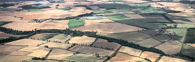
© Patricia & Angus Macdonald/Aerographica
The approach employs a detailed desk study using digital data within a geographic information system (GIS) to identify Integrated Habitat Networks (IHNs). The spatial position and extent of functional integrated habitat networks were determined through a landscape ecology model from the BEETLE (Biological and Environmental Evaluation Tools for Landscape Ecology) suite of tools.
The BEETLE least-cost focal species approach negates the need to carry out a vast number of individual species analyses. The selection of the habitats to be modelled, and the species used to inform the analysis, were identified through a series of expert stakeholder workshops. The outputs can support the planning process, help prioritise conservation effort, prevent further fragmentation of biodiversity and aid connectivity of semi natural habitats.
BEETLE model analysis has been well referenced (Watts et al., 2005) and used in a variety of projects such as developing forest habitat networks across Scotland. The application of IHNs is the first time that the multiple habitat network approach has been used to solicit planning and development programmes in key areas.
Two IHN studies have been undertaken:
To identify:
Watts, K., Humphrey, J.W., Griffiths, M., Quine, C.P. and Ray, D. (2005). Evaluating biodiversity in fragmented forest landscapes: principles (PDF-488K) . Forestry Commission Information Note 73. Forestry Commission, Edinburgh.
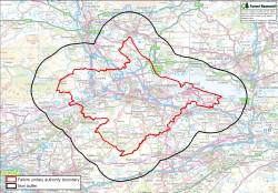
Located between the Campsie Fells and the Forth, Falkirk sits in a narrow lowland area in between the southern and northern lowland areas of Scotland, making it an important corridor for species dispersal. The area has an industrial past and there is now the opportunity to restore habitats and enhance biodiversity.
Much of the land is of agricultural importance, with more designated as improved grassland. Little semi-natural land remains and there is limited forest cover. Despite this Falkirk is an area of biodiversity importance. The Falkirk Forth shore is home to 4 SSSIs designated as RAMSAR sites and great effort is being made to restore natural sites.
For complete list of the key findings and recommendations please see the report:
Falkirk Integrated Habitat Networks (PDF-2131K)
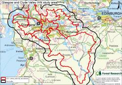
The Glasgow and Clyde Valley (GCV) catchment contains a wide of range of diverse habitats and landscapes types. A long history of intensive land-use throughout the GCV has resulted in the loss and fragmentation of semi-natural habitats and a subsequent reduction in biodiversity. Conservation policy and practice now seek to reverse the effects of fragmentation by combining site protection and rehabilitation measures with landscape-scale approaches that improve connectivity and landscape quality.
The 2006 GCV Structure Plan promotes the vision of a Green Network that spans the eight local authority areas which constitute the GCV area. The Integrated Habitat Network (IHN) modelling approach will support this by providing a strategic framework for functioning habitat networks across the GCV focusing on three key habitat types.
The development and application IHN modelling provides a Decision Support Tool that can identify areas that are ecologically connected and can be used to target and justify planning gain and conservation effort in relation to policy drivers.
Habitat network modelling has the potential to support and guide the planning process and to target conservation effort by highlighting areas that prioritise the greatest development potential of habitat protection and enhancement. An analysis of the habitat networks was undertaken on a GCV wide basis to identify potential Priority Enhancement Areas. These are key areas for habitat restoration detailed in the GIS maps chosen on the basis that they are:
The Priority Enhancement Areas include areas such as the Clyde Valley and Kilpatrick Hills woodlands, the wetlands of the Kelvin and Forth Clyde canal and the unimproved grasslands of Renfrewshire.
The identification of Priority Enhancement Areas will help target effort towards the development of networks for woodlands, wetlands, and grasslands in these areas and will also help link the GCV IHN to neighbouring habitat networks in Falkirk, Loch Lomond and the Trossachs National Park, and Edinburgh and the Lothian, further highlighting the importance of ecological connectivity throughout Scotland’s Central Belt.
In addition to the GCV wide analysis the model was applied to individual sites to demonstrate how optimal solutions can be found which do not negatively affect proposed developments, but which can incorporate strategically located habitats to provide connectivity and enhance the network. This type of analysis will be extremely useful in informing master planning or the development of Community Growth Areas or Corridors.
For full details see report below:
Glasgow and Clyde Valley Integrated Habitat Networks (PDF-1697K)
Glasgow & Clyde Valley Green Network Partnership
Abbreviations:
HN: Habitat Network
FHN: Forest/Woodland Habitat Network
LHN: Lowland Habitat Network
Senior Forest Ecologist

Principle Landscape Ecologist