Summary
Background
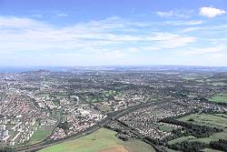
Photo: Patricia & Angus MacDonald/Aerographica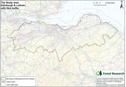
The region of Edinburgh and the Lothians covers an area of approximately 171,500 ha (see map on right) with a population of about 778,000, and is divided into 4 unitary authorities:
- Edinburgh City Council
- East Lothian Council
- Midlothian Council
- West Lothian Council.
Each authority provides local plans that are linked by a regional structure plan.
The structure plan was recently reviewed to adapt to changes in the demographic situation of the region due to renewed economic growth. This in turn has resulted in a new housing requirement of 5,000 units per annum. Such an expansion creates intense pressure on land-use decisions, and requires careful planning to ensure that environmental and social needs are not compromised.
Although much of the non-developed land is agricultural, the region does have a significant area of woodland (about 13%), and large open-ground heathland areas.
This study attempts to assess the biodiversity contribution made by woodlands and heathland at the landscape scale, and to evaluate where effort should be targeted to consolidate high quality habitat, and link existing network components by woodland expansion.
Objectives
In the Edinburgh and Lothians region of lowland Scotland:
- Identify existing woodland and heathland habitat networks
- Classify woodlands in terms of biodiversity quality
- Examine how and where woodland expansion should be integrated into urban development
- Examine where opportunities exist for improving community access to woodland
- Provide detailed example plans for consolidating, expanding, and linking forest habitat networks
- Identify the UKBAP priority open ground habitat, where woodland expansion is not appropriate.
Methods
Woodland biodiversity quality was assessed using expert knowledge and coincidence mapping of ancient woodland indicator vascular plant species.
The approach recognised that whilst the presence of one ancient woodland indicator species might occur by chance, or have been introduced, and would therefore not necessarily reflect biodiversity quality, the presence of additional species would strengthen the quality argument [Peterken, G. F. (2000). “Identifying ancient woodland using vascular plant indicators.” British Wildlife, 11, 153-158].
The number of species used to provide a guide to biodiversity quality was defined as:
- Fewer than 4 ancient woodland indicator plants equals low quality woods
- 4 to 7 ancient woodland indicator plants equals good quality less fertile woods and moderate quality fertile woods
- 8 or more ancient woodland indicator plants equals high quality fertile woods.
The Habitat Network Tool from BEETLE (Biological and Environmental Evaluation Tools for Landscape Ecology) was used to assess the functional connectivity within habitat networks, selecting woodlands of high biodiversity value to form Core Woodland Areas, indicating opportunities for consolidating, expanding, and linking forest habitat networks in relation to Local Plans.
The Woodland Trust’s ‘Space for People’ criteria were used to identify the accessibility of woodlands over 2ha and over 20ha to population centres.
Publication
- FHN_for_Edinburgh_and_Lothians.pdf (PDF-831K)
Results
A Forest Habitat Network for Edinburgh and the Lothians – full report (PDF-2460K)
Functionally connected habitat networks: the maps below show the extent and total area of functionally connected habitat in each network.
- Core Woodland Areas comprise areas where the high biodiversity quality networks may be linked together.
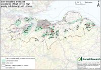
The map shows the locations of core woodland areas and very high and high quality woodlands in Edinburgh and Lothian.
- Woodland quality networks identified from coincidence mapping of ancient woodland indicator species.
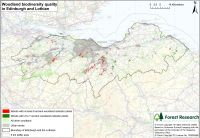
The map shows the woodland biodiversity quality, indicated by the number of species of ancient woodland indicator plants occurring in the woodland.
- By laying the high quality networks on top of non-qualified woodland networks, opportunities for woodland conservation, restoration and buffered expansion can be explored.
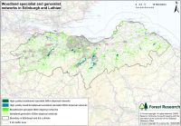
The map shows individual networks for woodland generalists, each network separately colour coded to show the extent and functional connectivity of large woodland networks.
- Priority open ground habitats were identified to ensure these areas are not compromised by development or woodland expansion.
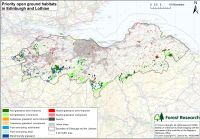
The map shows the priority open ground habitats in the region.
- Areas that do not meet Woodland Trust woodland accessibility criteria were identified.
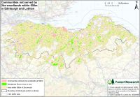
The map shows communities not served by 2 ha woodlands within a distance of 500 m.
- The interaction between networks and Local Plans indicate where network linkages need to be secured to prevent the opportunity being lost forever.
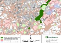
The map shows the high quality woodland network of the Esk Valley and the development requirements of the Waverley Corridor.