Summary
Background
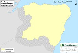
The Grampian forest habitat network study area is defined by the Forestry Commission Conservancy boundary (yellow area on map below), with an external 15 km buffer applied (hatched area on map below). This comprises approximately 1.2 million ha, of which Grampian Region covers 880 115 ha:
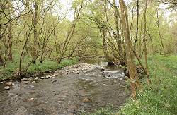
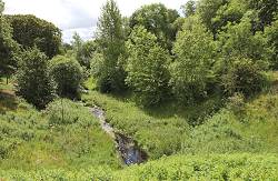
Grampian Region is comprises a mosaic of land cover types, within a varying topography, from the farmland of the Buchan Plains to the wooded slopes of the Cairngorm mountains. Riparian and wet woodlands are an important component of the wooded landscape and the former are especially important, in terms of connectivity, as they often form corridors linking other areas of woodland.
Objectives
- Identify the key woodland and heathland habitats in the region to enable a habitat network analysis to be undertaken
- Determine the extent of riparian and wet (Carr) woodlands in the region
- Identify priority open ground habitat where woodland expansion is not desirable
- Identify improvement, restoration and expansion priorities for the forest habitat networks.
Methods
Habitat network analyses for the region focused on an open ground habitat, heathland and five woodland types:
- Broadleaved woodland
- Riparian woodland
- Wet (Carr) woodland
- High biodiversity pinewood
- All pinewood.
The study also attempted to identify riparian and wet (Carr) woodlands by incorporating a number of methodologies, which were given a hierarchy of confidence:
- Wet woodlands identified through surveys
- Scottish Semi-Natural Woodland Inventory where tree type equals broadleaved or mixed and category was watercourse
- Woodland polygons associated with a high number of vascular plant indicator species associated with riparian and wet (Carr) woodland (see Edinburgh and Lothians habitat networks for another example of coincidence mapping)
- Woodland polygons relating to derived flood risk areas
- Woodland polygons relating to Native Woodland Model wet woodland types.
Results
Forest Habitat Networks Scotland – Grampian Report (PDF-4471K)
Maps showing the potential extent of functional networks for riparian woodlands were examined by ‘nesting’ these networks within broadleaved networks and woodland generalist networks:
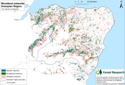
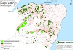
This procedure also enabled wet (Carr) woodland networks, and pinewood networks (map below) to be examined to support regional strategic plans for Grampian:
The networks can also be used at a local scale to determine and prioritise opportunities to reduce habitat fragmentation:
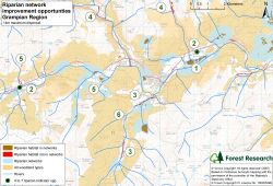
In the above example, the numbers refer to the opportunities listed below:
- Areas of habitat within the riparian networks where appropriate management should be undertaken to achieve of maintain favourable condition, e.g. management of areas of riparian woodland within the riparian habitat network (core sites).
- Areas of habitat associated with 4 to 7 riparian woodland indicator species should be managed to protect the integrity of the woodland and create conditions favourable for further species colonisation.
- Areas of habitat out-with the riparian network but downstream and adjacent to the networks, where restoration and expansion will provide large enough areas to support a range of species associated with riparian woodland. These should be priority areas for restoration.
- Areas of riparian woodland out-with, upstream, and isolated from existing networks. These should be high priority areas as the threat of species loss and the low likelihood of future colonisation means these are particularly vulnerable areas.
- Management of intervening wetland habitat, which will facilitate dispersal of riparian species between habitat, increasing network size and connectivity.
- Creation of new areas of riparian woodland between existing riparian networks which will, over time, form stepping stone habitat to functionally link the networks.