Summary
Background
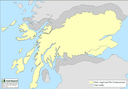
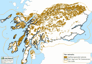
The study area was defined by the Forestry Commission Scotland (FCS) Perth and Argyll, Conservancy boundary and Fife, with a 15 km external buffer (see map).
The area stretches from the wet Atlantic west coast to the dryer east coast, consisting of 6 six unitary council areas and comprising approximately 2,500,000 ha, of which over 520,000 ha is woodland. Much of the woodland comprises coniferous plantations located in the west, with areas of native Pinewood towards the east and broadleaved riparian woodland along valleys and around lochs.
Objectives
In the study area:
- Identify the key woodland and heathland habitats to enable a Habitat Network analysis to be undertaken.
- Provide recommendations for estimating where opportunities exist for protecting, improving, and expanding specialist networks within the larger woodland generalist network.
Methods
- The Habitat Network tool from BEETLE (Biological and Environmental Evaluation Tools for Landscape Ecology) was used to assess habitat network extent, focusing on three woodland types: pinewood; broadleaved woodland; all woodland, and heathland as an open ground habitat.
- Habitat network maps showing the potential extent of functional networks were examined by ‘nesting’ the pinewood and broadleaved specialist networks within woodland generalist networks.
Results
Habitat network maps (below) show the potential extent of functional networks that can be incorporated into strategic plans for the region to reduce habitat fragmentation:
Broadleaved woodland 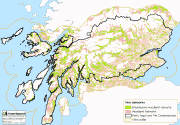
Pinewoods 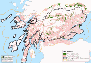
Heathland