Summary
Background
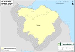
The Borders and the Lothians study area was defined by the 5 unitary authority boundaries of:
- Edinburgh City Council
- West Lothian Council
- Midlothian Council
- East Lothian Council
- Scottish Borders Council
with an external 15 km buffer applied to the external boundary (see map on right).
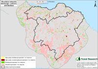
Woodland constitutes approximately 19.5% of the area, of which 60% is coniferous woodland, and the remainder broadleaved woodland, mixed woodland, and scrub.
Only small remnant ancient semi-natural woodlands remain, the exact amount is uncertain because the Ancient Woodland Inventory was not completed for the region.
The landscape of the Borders and the Lothians has been highly modified by man, historically by farming practice, and in more recent times by the increasing urban spread. The impact of farming has defined the fragmented wooded landscape, with small wooded areas, occasionally interconnected by strips of shelterbelt woodland along field boundaries.
Objectives
For the area of the Lothians and the Scottish Borders:
- Undertake a detailed analysis of specialised woodland networks by incorporating a woodland quality assessment, with particular attention to broadleaved woodland in riparian areas.
- Provide recommendations to improve networks, with detailed examples of consolidating, expanding, and linking forest habitat networks at regional and local scales.
- Examine whether the distribution and extent of habitat networks would facilitate species movement and dispersal across southern Scotland in response to climate change pressures.
- Provide a tool for addressing the aspirations of the region’s Local Biodiversity Action Plan for woodlands.
Methods
- Qualification of woodland biodiversity from an assessment of woodland structure, deadwood and field layer components from interviews with woodland experts.
- Qualification of woodland biodiversity quality from coincidence mapping of vascular plant species indicative of ancient and long-established woodland.
- Focus on broadleaved woodland specialists, particularly those associated with very high biodiversity quality woodlands.
Results
Forest Habitat Networks Scotland – Borders and the Lothians report (PDF-2086K)
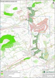
The functional networks produced were examined by ‘nesting’ networks for woodland specialists within the generalist networks.
The networks provide a valuable decision-support tool, indicating where opportunities exist to reverse woodland fragmentation, using management techniques ranked in importance in the following way:
- Consolidation of existing high quality habitat, to reduce further fragmentation and maintain habitat viability, and conserve biodiversity
- Buffered expansion and restoration to increase patch size
- Increase connectivity to provide opportunities for dispersal and to increase patch size.
Examples of opportunities are shown below:
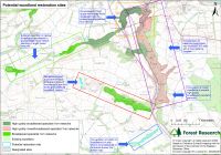
The networks can also be used as part of a strategy to maintain or improve robust networks capable of allowing species dispersal and movement as a result of climate change pressure.
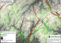
The map illustrates how species might disperse from the south, through Liddesdale following Liddel Water and crossing to Slitrig Water to disperse northwards. Another dispersal route is indicated from the southeast, following the River Rede and crossing to Jed Water through Kielder forest.