
Overview
The Research Forest is representative of a wide range of upland and lowland Scottish woodland categories, encompassing a broad range of tree species, soil and terrain types.
Its primary objectives are to enable Forestry & Land Scotland and Forest Research to work together to develop 21st Century forestry practices, and to optimise the transfer of scientific knowledge into practical solutions for Scottish and British forestry.
Explore the distinctive history, climate, geology, soils and structure of these woodlands to understand how this extensive natural resource continues to support modern forestry research and helps us understand how to adapt management practices to a changing climate and to create resilient, multi-purpose future forests.
Location
The Research Forest is located in the historic counties of Stirlingshire and Perthshire, Scotland, and extends from Ben Lomond in the west to Aberfoyle in the east, marking the transition from the Lowlands to the Highlands of Scotland.
It covers an immense, landscape-diverse area of around 24,500 hectares and is divided into 12 separate woodland management units which include the vast forests of Loch Ard and Achray, along with the smaller blocks by Loch Katrine, at Garadh Ban and the Forth Mosses. The Research Forest is almost entirely contained within the Loch Lomond & The Trossachs National Park and also includes most of the afforested areas of the Queen Elizabeth Forest Park. The woodlands are easily accessible from most areas of the populous Central Belt of Scotland and are critically important for tourism and recreation, receiving over 1 million visitors annually.
The Park contains many walking and cycling trials, the scenic Three Lochs and Duke’s Pass forest drives, prominent viewpoints and the centrally-located David Marshall Lodge Visitor Centre. They are also highly important for conservation; supporting red squirrel, capercaillie, black grouse golden eagle, osprey, peregrine falcon and merlin, along with many native woodland and temperate rainforest remnants.
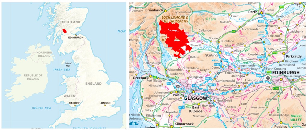
The Loch Lomond & The Trossachs Research Forest contains more than 12,000 hectares of woodland cover, of which approximately 65% is coniferous and 35% broadleaf. In addition, there are around 11,600 ha of non-woodland terrestrial habitats and 200 ha of open water. A further 200 ha of ground is either under recreational, agricultural or nursery uses, archaeological designations, mineral workings or other types of built estate.
Some 400 ha of coniferous woodland has been felled in recent years and awaits either replanting as woodland or restoration to other priority habitats. The Research Forest is serviced by the FR Field Data Services Team, which undertakes terrestrial and aerial forest surveys whilst providing expert support for the establishment, maintenance and assessment of field trials.
The history of local afforestation and forestry research
The original oak and birch woodlands around Aberfoyle and The Trossachs are believed to have been actively managed for tan bark, charcoal, construction timber and pit-props since at least the 16th Century.
The Forestry Commission began to acquire land and estates in the area in 1928, beginning with ground at Loch Ard. Tree-planting commenced in 1930, and further acquisitions and planting continued until the 1960s; broadly dominated by the use of pines on heathland, spruces on ground dominated by grasses and rushes, and larches on bracken sites. The Queen Elizabeth Forest Park was established in 1953 by the Forestry Commission in honour of the coronation. It contained the extensive new forests at Loch Ard, Achray and Rowardennan, and was founded on the principle that the mountain and other open landscapes acquired for state forestry should also allow free access for public enjoyment.
An important experimental area was established at Garadh Ban Forest in the 1950s and this made a significant contribution to our current understanding of broadleaf species-site matching and nursing mixtures. During the 1960s, Achray Forest hosted a number of under-planting, cultivation, drainage and fertilising trials. In recognition of the importance of having such a wide range of research potential within one easily-accessible location, Queen Elizabeth Forest Park was launched as Scotland’s Research Forest in 2014, supported by ClimateXChange: ‘Scotland’s centre of expertise for connecting climate change research and policy’, a partnership between the Scottish Government and various other land-based research providers.
It was re-branded in 2024 as the Loch Lomond & The Trossachs Research Forest, in alignment with the surrounding National Park.
Situation, relief and drainage
The Research Forest occupies the lower slopes of Ben Lomond to the west (974 m) and Ben Venue to the centre (727 m), and the mid-sized hills of The Trossachs to the north (500-700 m) and the Menteith Hills to the east (400 m).
The woodlands occupy a significant area of the upper Forth Valley catchment. The Loch Ard forest area drains via an extensive network of burns and small rivers towards Duchray Water and onwards to the River Forth. The smaller blocks to its southeast drain towards the Forth via the Kelty Water and Flanders Moss, whilst Garadh Ban Forest falls within the Loch Lomond catchment.
The large Achray Forest drains mainly via steep, fast-flowing burns towards the Loch Achray and Loch Venachar towards the River Teith. The smaller woodland blocks to the north of the Research Forest drain to Loch Katrine: an important water supply for Glasgow which is served by two underground aqueducts. The areas between Kinlochard and Aberfoyle, and between Loch Achray and Loch Venachar are prone to river-flooding.
The entire area of the Research Forest straddles two large drinking water protection zones: Trossachs to the north and Balloch to the south.
Climate
The Loch Lomond & The Trossachs Research Forest falls within the UK Meteorological Office’s Scotland Climate Region, the Scotland West Climate District, and the Western Scotland Climate Area. It occupies an interesting location somewhat in-between the wetter, windier west of Scotland and the warmer, drier east, so weather patterns can be complex with pronounced local differences. The climate type is maritime (temperate) with local conditions varying, with elevation from warm and moist to cool and wet. Summers are mild-to-warm, winters are cool and damp with regular air and ground frosts.
The Research Forest benefits from a local weather reporting station at Arrochymore, just west of the Garadh Ban and Corrie forest blocks, enabling current and historical climate data to be compared regionally and nationally. (Forest Research has also installed its own automatic weather station within the Duchray catchment.) The table below summarises and contrasts Met. Office data from 1991 to 2020 for the Loch Lomond area and its respective climate district and climate region, along with averages for England and Wales and the UK.
Winters are expected to become milder whilst rainfall, mean annual temperatures and the frequency of damaging storms are all predicted to increase throughout the 21st Century, bringing challenges but also opportunities for local forest, slope and floodplain management.
| Annual mean max. temperature (°C) | Annual mean min. temperature (°C) | Annual mean air -frosts (days) | Annual mean sunshine (hours) | Annual mean rainfall (mm) | Annual mean rainfall (days) | |
| Arrochymore Reporting Station | 12.85 | 5.57 | NA | 1179.41 | 1771.66 | NA |
| Scotland West District | 11.65 | 5.02 | 57.58 | 1240.71 | 1817.58 | 196.86 |
| Scotland Region | 11.07 | 4.41 | 71.70 | 1199.63 | 1572.65 | 191.28 |
| England & Wales Average | 13.69 | 6.10 | 45.12 | 1520.22 | 950.81 | 140.38 |
| United Kingdom Average | 12.79 | 5.53 | 53.37 | 1402.61 | 1162.67 | 159.08 |
Geology and soils and natural habitat development
The Research Forest covers a large and geologically diverse area.
Towards its southern end occurs the Highland Boundary Fault, running approximately southwest to northeast, centred on Aberfoyle, separating the Highlands of Scotland from the Central Lowlands or Central Belt. The central, western and northern areas of the Research Forest, i.e. those to the north of the Fault, lie on hard, coarse metamorphosed sedimentary formations of meta-sandstones, grits and slates of the Ediacaran Period. The areas to the south of the Fault (around Drymen, Dalmary and Aberfoyle) are underlain by softer sedimentary sandstone and mudstone formations of the Devonian Period.
Areas of superficial deposits are concentrated above the areas of sedimentary geology and are largely diamicton / glacial till between Drymen and Dalmary, or deeper peats at Flanders Moss. The diverse landscapes of the larger forest blocks at Achray and Loch Ard are reflected in a complex mosaic of soil types which include podzols, iron pans, gleys, brown earths and peats.
The Research Forest contains two important special areas of conservation: the River Teith SAC (for fish) and the Trossachs Woods SAC (ancient, semi-natural woodland), along with a number of geological and native woodland sites of special scientific interest (SSSIs).
Tree species
The range and relative areas by trees, by species and species group represented at the Loch Lomond & The Trossachs Research Forest are shown in the table below. These also include significant areas of remnant pinewoods and Atlantic oakwoods, amongst other areas of native woodland. Further details of the location, age and area of individual stands of trees are available, upon request, if any of the species are of interest to you for study purposes.
| Scientific name | Area (ha) | |||
| Broadleaf | Birch (silver / downy, unspecified) | Betula pendula / pubescens | 1,606.9 | |
| Rowan | Sorbus aucuparia | 775.0 | ||
| Oak (ped. / sessile, unspecified) | Quercus robur/petraea | 407.4 | ||
| Willow, grey | Salix cinerea | 110.8 | ||
| Alder, common / native | Alnus glutinosa | 68.3 | ||
| Birch, downy | Betula pubescens | 64.4 | ||
| Oak, sessile | Quercus petraea | 64.1 | ||
| Alder (other, unspecified) | Alnus spp. | 48.3 | ||
| Aspen | Populus tremula | 43.2 | ||
| Willow, goat | Salix caprea | 38.8 | ||
| Birch, silver | Betula pendula | 37.7 | ||
| Ash (European, common) | Fraxinus excelsior | 25.6 | ||
| Hazel | Corylus avellana | 18.9 | ||
| Cherry, wild / gean | Prunus avium | 15.0 | ||
| Beech | Fagus sylvatica | 14.4 | ||
| Hawthorn (species unspecified) | Crataegus spp. | 10.8 | ||
| Sycamore | Acer pseudoplatanus | 9.1 | ||
| Cherry, bird | Prunus padus | 7.2 | ||
| Holly, European | Ilex aquifolium | 5.7 | ||
| Willow (other, unspecified) | Salix spp. | 5.5 | ||
| Willow, white | Salix alba | 3.7 | ||
| Birch, other species | Betula spp. | 3.3 | ||
| Oak, pedunculate | Quercus robur | 3.2 | ||
| Maple, field | Acer campestre | 3.1 | ||
| Chestnut, sweet | Castanea sativa | 3.0 | ||
| Yew | Taxus baccata | 2.5 | ||
| Alder, grey | Alnus incana | 2.1 | ||
| Cherry, other, unspecified | Prunus spp. | 1.7 | ||
| Lime (European, common, linden) | Tilia × europaea | 1.0 | ||
| Alder, red | Alnus rubra | 0.9 | ||
| Elm, wych | Ulmus glabra | 0.6 | ||
| Oak, red | Quercus rubra | 0.3 | ||
| Mixed, unspecified, or other ‘minor’ broadleaves: | 910.1 | |||
| Total broadleaf | 4312.5 | |||
| Conifer | Spruce, Sitka | Picea sitchensis | 5,479.3 | |
| Pine, Scots | Pinus sylvestris | 810.2 | ||
| Spruce, Norway | Picea abies | 518.0 | ||
| Pine, lodgepole | Pinus contorta | 272.4 | ||
| Fir, Douglas | Pseudotsuga menziesii | 160.0 | ||
| Larch, hybrid | Larix × eurolepis | 137.1 | ||
| Larch, Japanese | Larix kaempferi | 95.1 | ||
| Larch, European | Larix decidua | 54.2 | ||
| Hemlock, western | Tsuga heterophylla | 34.4 | ||
| Fir, noble | Abies procera | 21.5 | ||
| Cedar, western red | Thuja plicata | 20.8 | ||
| Cedar, Atlas | Cedrus atlantica | 8.9 | ||
| Juniper, common | Juniperus communis | 7.5 | ||
| Cedar, other, unspecified | Cedrus spp. | 6.8 | ||
| Fir, Pacific silver | Abies amabilis | 4.1 | ||
| Fir, European silver | Abies alba | 4.0 | ||
| Pine, Macedonian | Pinus peuce | 3.9 | ||
| Fir, grand | Abies grandis | 3.7 | ||
| Cedar, Japanese | Cryptomeria japonica | 3.4 | ||
| Redwood, coast | Sequoia sempervirens | 2.7 | ||
| Spruce, Serbian | Picea omorika | 2.3 | ||
| Cypress, Lawson | Chamaecyparis lawsoniana | 0.6 | ||
| Pine, Corsican | Pinus nigra (subsp. Laricio) | 0.3 | ||
| Pine, Weymouth | Pinus strobus | 0.3 | ||
| Larch, other, unspecified | Larix spp. | 0.3 | ||
| Fir, other, unspecified | Abies spp. | 0.2 | ||
| Pine, bishop | Pinus muricata | 0.1 | ||
| Mixed, unspecified, or other ‘minor’ conifers: | 145.8 | |||
| Total conifer | 7,797.6 | |||
| Total woodland | 12,110.1 | |||
Key management and research challenges
The extensive areas of woodland that form the Research Forest are managed by Forestry & Land Scotland (FLS) as productive, multi-purpose forests within a diverse and sensitive landscape. The woodlands are about two-thirds coniferous. The most commonly-planted species is Sitka spruce, which accounts for 45% of the total woodland area. Scots pine accounts for about 7%, Norway spruce 4%, larches 2%, Lodgepole pine 2% and Douglas fir 1%. There are substantial areas of birch-dominated woodland (13%), some oakwoods (3%) and substantial areas of other native-type woodland and open ground representing a large and complex network of habitats of principal importance.
Current management challenges and objectives for FLS include the need to increase tree species and age diversity, to restructure the woodlands in order to reduce flood risks and improve water quality, to protect and enhance areas of ecological importance, to prevent the further spread of larch ramorum disease, to maintain and improve recreational opportunities, and to increase resilience to future climatic threats whilst continuing to manage areas of the forest for high quality timber production.
In support of these objectives, Forest Research is working in partnership with FLS to extend the planting of native broadleaf and montane scrub woodland to higher elevations (i.e. beyond the current tree-lines) to increase woodland cover and promote slope stability, to identify alternative main tree species in order to improve overall structural and species diversity, and also to restore peat and bogland ecosystems. A Natural Flood Management demonstration area has been developed at Allt Glas, around Duchray Water and upstream from Aberfoyle, in order to reduce peak stream flows. FR and FLS are also working together to transition, where feasible, away from the conventional management practice of clear-felling and replanting towards lower-impact silvicultural systems with an emphasis on ‘continuous cover’. Here, elements of the older woodland are retained to provide a seed-source and shelter for the natural regeneration of seedlings or for the underplanting of young trees, beneath an existing canopy.
The Loch Lomond & The Trossachs Research Forest is of great importance for modern climate-smart forestry research, as it represents a historical exercise in successful afforestation on challenging soil and habitat types that are representative of other upland sites where future woodland expansion in Great Britain may be considered.
References
ClimateXChange (FR research page, accessed October 2026)
Edlin (1969). Forest Parks. Forestry Commission Booklet 6, HMSO
Edlin (1969). Forests of Central and Southern Scotland. Forestry Commission Booklet No. 25, HMSO
Forestry & Land Scotland. Queen Elizabeth Forest Park (website, accessed October 2026)
Loch Lomond & The Trossachs National Park (website, accessed October 2026)
Meteorological Office. UK Climate Districts Map (website, accessed October 2026)
Meteorological Office. UK Climate Regions Map (website, accessed October 2026)
Meteorological Office. UK Regional Climate Summaries (website, accessed October 2026)
Meteorological Office. Arrochymore Location-Specific Long-Term Averages (website, accessed October 2026)
Scotland’s Climate Ready Forest Network (FR research page, accessed October 2026)
Scottish Government. Scotland’s Environment Map (website, accessed October 2026)