Summary
Project background
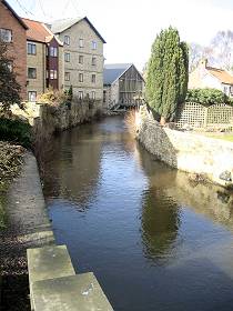 View of Pickering Beck from The Ropery Bridge, central Pickering
What is the project?
Slowing the Flow at Pickering seeks to demonstrate how better land management can help to tackle the flooding problem faced by Pickering in North Yorkshire, in common with many other towns and cities across the country.
Flooding appears to be an increasingly common event and one that could get even worse with climate change. Pickering has been flooded four times in the last 10 years (1999, 2000, 2002 and 2007), with the last flood the most serious to date, causing damage to homes and businesses valued at approximately £7m. The impact of the 2007 floods was particularly severe across the whole of the Yorkshire and the Humber Region, with the total damage estimated at £2.1 billion.
Who is involved?
Slowing the Flow at Pickering is a partnership project. It is led by Forest Research, closely supported by Forestry Commission England, The Environment Agency, The North York Moors National Park Authority, Durham University, Natural England and the wider community. The lead funder is Defra.
There is a great deal of public interest in the project and local people and organisations are actively encouraged to participate and help achieve a successful outcome.
What do we mean by land management?
The new approach to flood management relies on making changes to the way the landscape is managed, so that the passage of rainfall to rivers and its movement downstream is reduced and delayed. This involves a range of ‘measures’, including:
- Constructing low-level bunds
- Planting more trees, especially along streamsides and in the floodplain
- Restoring woody debris dams in small streams
- Restoring wetlands.
How will we measure success?

Pickering Beck and River Seven catchments in North Yorkshire
Map size: A3 landscape at 96dpi, 655Kb.
Opens in a new window.
The aim of the project is to implement a range of land management measures that will slow down water in the upper catchment, store more in the middle section and improve its conveyance through the town. Success will be gauged by the number of measures that are implemented and by their combined effect on the frequency of future flooding in Pickering.
Initially, mathematical models were used to estimate the impact on flood risk but continued monitoring of river flows will allow these predictions to be tested and to prove whether the measures have been effective. The wider environmental benefits of the measures will also be assessed.
REports and papers
Slowing the Flow at Pickering is one of three pilot projects nationwide to receive a total of £1 million of Defra funding. The aim is to demonstrate how our natural resources can help protect against flooding. The funding is part of £28 million which DEFRA has allocated to fund projects that help communities adapt to changing flood risk in the face of climate change.
The two sister projects are:
- Holnicote Estate, near Minehead in Somerset – project managed by the National Trust
- Upper Derwent Valley, Derbyshire – project managed by Moors for the Future
For further contextual information on flooding and flood management please visit:
- Flood risk management guidance. (Defra)
- Natural flood management (Environment Agency)
- Forest hydrology (Forest Research)
News, presentations and site visits
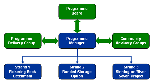
Partnership Board
Senior representatives from the main partners, responsible for steering and overseeing the project.
Programme Delivery Group
Representatives from funding and regulatory bodies plus land owning and managing organisations. Responsible for development and implementing measures approved by the Board.
Programme Manager
Tom Nisbet
Public face of the project and responsible for overall co-ordination and engagement.
Community Advisory Groups
Appointed representatives from Pickering Flood Defence Group, Ryedale Flood Research Group and the Civic Society to inform and represent the community via the Wider Delivery Group.
Strand 1: Pickering Beck Catchment – land management
Planning and implementing a range of land management measures designed to slow down flood flows in the upper catchment of Pickering Beck.
Led by the Forestry Commission.
Strand 2: Pickering Beck Catchment – bunded storage option
Designing low level bunds to increase the storage of floodwaters in the lower reaches of the Pickering Beck.
Led by the Environment Agency.
Strand 3: River Seven Catchment – land management
Installing large woody debris dams within Cropton Forest and creating new woodland to slow down flood flows in the River Seven.
Led by the Forestry Commission.