Summary
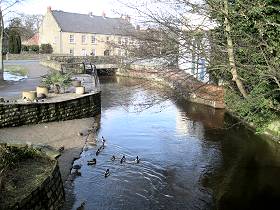
The Beck flowing past business and residential property at risk of flooding in central Pickering
Flood risk in the region
The impact of the 2007 floods was particularly severe in the Yorkshire and Humber Region, with the total damage estimated at £2.1bn. Climate change may increase the frequency of such floods, resulting in a major recurrent cost with significant implications for the regional economy and for affected communities.
The Catchment Flood Management Plans for the region note that the current reliance on engineered flood defences to defend all areas against future flooding is not sustainable. Instead, they identify a need to develop a whole catchment approach to flood risk management.
Land management is recognised as having a significant contribution to make, particularly where engineered flood defences cannot be justified on cost-benefit grounds, but also to improve the effectiveness of existing defences against climate change. It is also consistent with the delivery of an ecosystem services approach to securing a healthy environment.
Why choose Pickering?
The Pickering Beck catchment in North Yorkshire is an ideal, although challenging site to explore how land management practices within an environmentally sensitive area can be modified for flood risk reduction.
Pickering has a long history of flooding and whilst a flood alleviation scheme has been proposed in recent years, it is of too low a priority in terms of cost-benefit to be considered for approval. The town is particularly at risk from summer flash floods due to the steep nature of the catchment.
The project also includes the neighbouring catchment of the River Seven, where the village of Sinnington is similarly at risk from summer floods. This slightly larger catchment has a larger floodplain and an even faster flood response. Its inclusion extends the opportunity to demonstrate the benefits of larger-scale planting of floodplain woodland.
Problems with previous land management practices
Previous land management practices in the catchment are considered to have enhanced the risk of Pickering being flooded by promoting rapid runoff and increasing the delivery of sediment and siltation within Pickering Beck.
There are four principal land uses in the 66 km2 catchment, comprising:
- Arable crops
- Improved grassland
- Heather moorland
- Forestry and woodland.
Inappropriate cultivation of arable soils, overstocking and overgrazing of grassland, excessive moorland and forestry drainage, and poor river management, are all thought to have increased the risk of downstream flooding.
Opportunities presented
The project seeks to demonstrate the role of best land management practices in correcting past problems and restoring the catchment’s natural flood attenuation capacity. There is also the potential to explore a number of ‘win-wins’, including expected water quality and biodiversity gains associated with better land management.
Diffuse water pollution is another major local issue, with Pickering Beck failing to meet ‘good water status’ as defined by the Water Framework Directive. It has been designated a ‘Priority Catchment’ for improving land management under the England Catchment Sensitive Farming Delivery Initiative (ECSFDI), with additional funding provided for agri-environment schemes.
Related projects
The project builds on previous regional flood risk management projects:
- The SPROUT Project (Strategic Partnership for the River Ouse and its tributaries), which identified the important contribution of moorland gripping and coarse sediment delivery to local flood risk;
- The Ripon Multi-Objective Project, which highlighted the problems of persuading landowners to implement land management measures and the need to build a partnership that will secure change;
- Regional Forestry and Flooding Initiative, which developed a region-wide approach and opportunity mapping to facilitate targeted woodland creation for flood risk reduction;
- Rural Economy and Land Use Project, which pioneered new ways of incorporating local knowledge into strategic flood risk management and developed new hydrological models to assess the role of land management.
These projects identified a number of priority areas within the Pickering Beck and River Seven catchments where best land management practices are expected to be effective at reducing flood runoff and the delivery of sediment to watercourses.