About Yorkshire Research Forest
Discover how a century of forestry innovation on the North York Moors continues to shape woodland management and climate resilience across Great Britain.

During the early-to-mid 20th Century, afforestation works on the North Yorks Moors played a key role in developing our current understanding of upland forestry in Great Britain. These predominantly coniferous forests were established on upland moorland habitats and on predominantly podzolic, iron-pan soil types; a particularly challenging environment for forestry. These woodlands are the result of several decades’ worth of pioneering species, cultivation and nutrition trials.
Explore their distinctive history, climate, geology, soils and structure to understand how this extensive natural resource continues to support modern forestry research and helps us understand how to adapt management practices to a changing climate and create resilient, multi-purpose future forests.
The Yorkshire Research Forest comprises of two individual woodland blocks or ‘management units’: Wykeham Forest and Broxa Forest, which are located on the southern and eastern slopes of the North Yorks Moors, about 10 km west of Scarborough. Both woodlands are also important for recreation, containing a number of walking, cycling and horse-riding trails, along with hundreds of archaeological features including burial mounds, round and square barrows, ditches, earthworks and rabbit warrens.
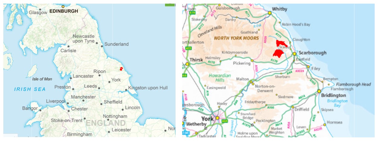
The Yorkshire Research Forest contains some 1,520 hectares of woodland cover, of which approximately 75% is coniferous and 25% broadleaf. In addition, there are around 140 ha of non-woodland terrestrial habitats and 100 ha of agricultural and nursery land, recreational sites, built estate and mineral workings. Forest Research maintains a local presence at the Wykeham Field Station, by North Moor (National Grid reference SE 947 863). From here, the FR Field Data Services Team undertakes terrestrial and aerial forest surveys whilst providing expert support for the establishment, maintenance and assessment of field trials.
Prior to the 20th Century there was very little plantation forestry and few native woodland remnants on the plateau moorlands between Pickering and Scarborough. Sheep grazing, sporting and warrenery were the primary land-uses. Extensive acquisitions for state forestry began in 1921 with Allerston Moor and Staindale (now the larger Dalby Forest), extending eastwards to Wykeham in 1924 and to Harwood Dale in 1927. Afforestation proceeded at a rate of around 180 hectares annum-1 during this period. At the time, there was little understanding of what tree species would grow well in these areas, and the challenges of heathland afforestation soon identified the need for extensive experimentation. In 1928 an area of 60 ha was designated at Wykeham Moor and was rapidly filled with trials, followed by extension of 65 ha at Broxa Moor in 1941. By the 1950s, a total of 155 trials has been established in what had become one of the largest experimental forestry areas in Great Britain.
Locally, Scots pine was known to perform poorly on uncultivated soils. Early trial plantings of spruce and larch on the Moors also proved unsuccessful, particularly where the soil was undisturbed or only shallow-ploughed. It was soon deduced that a greater depth of rooting medium was required for all tree species, and by the early 1930s trials of deep ploughing and drainage techniques had begun at Wykeham. By the 1950s the effective suppression of heather, cultivation by deeper ploughing and sub-soiling, and the use of ‘step’ planting into the sides of the ploughed ridges had been shown to have positive effects on the survival and performance of Japanese larch, Sitka spruce and Corsican and Scots pines. Corsican pine showed early stability problems at age 5-10 years and young trees required staking on more exposed ground. Beech performed poorly in mixture with pines, due to exposure and soil factors. Sitka spruce outperformed Norway spruce on cultivated heathland soils, particularly in mixture with Scots pine. The key findings of this early research were that the soils needed to be loosened and stirred in summer to enable better rooting and iron pans broken-up, followed by autumn-planting. Various trials and modifications to contemporary machinery resulted in the development of the highly-successful R.L.R. Forestry Plough (after the Forestry Commission Chairman, Roy Lister Robinson).
Species mixtures were a major element of these early trials including the successful use of pines, Japanese larch and even broom as a means to suppress regenerating heather and to act as nurse species to a main crop of Sitka spruce. There were also early provenance trials of lodgepole pine, Japanese and hybrid larches at Wykeham.
Forest nutrition trials established during the 1940s determined that the most important factor limiting the performance of spruce on moorland was a deficiency in available nitrogen, which could be remedied by removing directly-competing heather vegetation and by the application of nitrogenous fertilisers, although available calcium could also prove to be a limiting factor. Trials using basic slag phosphate as fertiliser also proved successful with most species, with pines benefiting the least.
The Moors were of considerable interest to researchers such as G.W. Dimbleby of the Department of Forestry at Oxford University, who noted the loss of the forest-acid soil complexes via their historical conversion to heathland and peat, and sought to determine the features of equilibrium between vegetation and soil that might form the basis of ecologically sound, long-term forestry. During the 1940s, trials were established at Broxa Moor to test the potential of over 40 species of hardwood trees for their adaptability to moorland, and also for their potential to improve degraded heathland soils. Some of these trials survive to this day and may offer useful insights into species choices for future climate-resilient forestry.
The Yorkshire Research Forest is located on the Tabular Hills, in the southeastern corner of the North Yorks Moors National Park. These fall broadly within the North York Moors and Cleveland Hills national character area (NCA); well-defined uplands which rise between the Vale of Pickering to the south, the Tees Lowlands to the north, and the Vale of Mowbray to the west. The woodlands occupy plateau moorlands, lying at between 140-220 m above sea-level. Although these areas fall sharply via escarpments to the north and east, woodland aspects are mostly southerly and are considerably exposed to the southwest, whilst also being subject to damaging easterly winds during springtime and potentially to salt-laden winds, due to their proximity to the coast. Broxa and Wykeham forests drain southwards towards the main River Derwent, via a number of small streams (‘becks’) and steep, ravine watercourses (‘gills’).
The North York Moors fall within the UK Meteorological Office’s England North Climate Region, the East and Northeast Climate District, and the Northeast England Climate Area. The Moors are exposed and are very cold during winter, although snowfall is generally low. The Research Forest benefits from a local weather reporting station at Fylingdales, about six miles to the northwest, enabling current and historical climate data to be compared regionally and nationally. The table below summarises and contrasts Met. Office data from 1991 to 2020 for the North York Moors, the East & Northeast District and the England North Region.
| Annual mean max. temperature (°C) | Annual mean min. temperature (°C) | Annual mean air -frosts (days) | Annual mean sunshine (hours) | Annual mean rainfall (mm) | Annual mean rainfall (days) | |
| Fylingdales Reporting Station | 11.46 | 4.96 | 58.49 | Missing | 979.68 | 151.25 |
| England East & Northeast District | 12.99 | 5.49 | 52.01 | 1492.78 | 793.05 | 133.80 |
| England North Region | 12.79 | 5.55 | 51.31 | 1433.03 | 985.89 | 147.36 |
| England Region | 13.82 | 6.12 | 45.15 | 1538.05 | 869.55 | 135.21 |
| England and Wales Region | 13.69 | 6.10 | 45.12 | 1520.22 | 950.81 | 140.38 |
| United Kingdom Average | 12.79 | 5.53 | 53.37 | 1402.61 | 1162.67 | 159.08 |
The plantation areas of the Yorkshire Research Forest are largely underlain by the Lower Calcareous Grit Formation of the Jurassic period; a fine-grained, quartzose sandstone. This was calcareous in origin, but the lime content has mostly been leached resulting in strongly acidic soils. Few superficial deposits are recorded on the plateau areas.
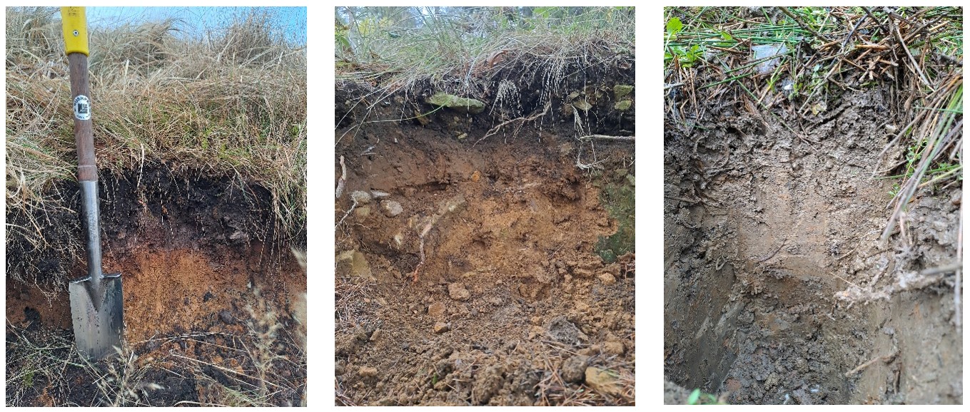
The soils are fairly homogenous and are mainly of the strongly-developed podzolic iron-pan type, with some minor areas of podzolic brown earth. Podzolization is believed to have commenced with the removal or deterioration of tree cover during the Bronze Age, caused by clearance and cultivation. Prior to modern afforestation the undisturbed soils typically comprised of an acidic, peaty surface layer of 5-8 cm depth above a grey, leached ‘A’ horizon followed by ‘B’ horizon of hard, rusty ironpan soil to around 45 cm depth above the parent material (left-hand and middle photos). These soils were of relatively low fertility, stony, compacted, free-draining, dry, very acidic, leached and dominated by heather. There are also some minor areas of surface-water gley soils (right-hand photo), stoney podzols, podzolic brown earths and typical brown-earths within the Research Forest.
The upland heaths are believed to have formed primarily in response to climatic factors; notably a fairly even distribution of annual rainfall, high humidity and an absence of prolonged periods of higher temperatures. Other factors such as soil type, natural drainage, grazing and fires may also have been important contributing factors.
The range and relative areas by trees by species and species group represented at the Yorkshire Research Forest are shown in the table below. Around 85 hectares have been felled and currently await either restocking with trees or restoration to other priority habitats. Further details of the location, age and area of individual stands of trees can be made available, upon request, if any of the species are of interest to you for study purposes.
| Scientific name | Area (ha) | ||
| Broadleaf | Birch (silver / downy) | Betula pendula/pubescens | 211.2 |
| Beech | Fagus sylvatica | 49.9 | |
| Oak (pedunculate / sessile) | Quercus robur / petraea | 27.7 | |
| Ash (European, common) | Fraxinus excelsior | 21.5 | |
| Sycamore | Acer pseudoplatanus | 10.5 | |
| Alder, common / native | Alnus glutinosa | 3.1 | |
| Poplar, hybrid | Populus × canadensis | 2.0 | |
| Rowan | Sorbus aucuparia | 1.7 | |
| Willow, goat | Salix caprea | 1.2 | |
| Nothofagus, Rauli (RAN) | Nothofagus alpina | 1.0 | |
| Nothofagus unspecified | Nothofagus spp. | 0.7 | |
| Chestnut, sweet | Castanea sativa | 0.5 | |
| Eucalypt, various species | Eucalyptus spp. | 0.2 | |
| Mixed or other ‘minor’ broadleaf | 26.2 | ||
| Total broadleaved | 357.4 | ||
| Conifer | Pine, Scots | Pinus sylvestris | 310.2 |
| Larch, Japanese | Larix kaempferi | 262.6 | |
| Spruce, Sitka | Picea sitchensis | 259.2 | |
| Larch, hybrid | Larix × eurolepis | 76.2 | |
| Fir, Douglas | Pseudotsuga menziesii | 76.0 | |
| Pine, Corsican | Pinus nigra (subsp. Laricio) | 42.8 | |
| Spruce, Norway | Picea abies | 26.4 | |
| Pine, lodgepole | Pinus contorta | 12.8 | |
| Hemlock, western | Tsuga heterophylla | 11.5 | |
| Fir, grand | Abies grandis | 5.7 | |
| Larch, European | Larix decidua | 4.2 | |
| Redwood, coast | Sequoia sempervirens | 4.1 | |
| Noble fir | Abies procera | 3.7 | |
| Spruce, Oriental | Picea orientalis | 3.6 | |
| Fir, Pacific silver | Abies amabilis | 1.2 | |
| Spruce, Serbian | Picea omorika | 0.8 | |
| Fir, European silver | Abies alba | 0.7 | |
| Wellingtonia / giant sequoia | Sequoiadendron giganteum | 0.4 | |
| Cypress, Lawson | Chamaecyparis lawsoniana | 0.3 | |
| Pine, Macedonian | Pinus peuce | 0.3 | |
| Mixed / other ‘minor’ conifer: | 60.3 | ||
| Total conifer | 1,162.8 | ||
| Total woodland | 1,520.2 |
The Broxa and Wykeham blocks are managed by Forestry England (FE) as productive, multi-purpose forests. They are largely coniferous and are currently dominated by pine (31%), larch (30%) and spruce (25%) species. There is still a significant component of Corsican pine, which in recent years has been heavily-affected by Dothistroma needle blight. Given the additional and unprecedented stresses of climate-change, there is an urgent need to diversify the forest using a wider choice of genera and species.
Through its long-term forest planning process, FE is substantially transitioning from the conventional management practices of clear-felling and replanting towards lower-impact silvicultural systems with an emphasis on ‘continuous cover’. Here, elements of the older woodland are retained to provide a seed-source and shelter for the natural regeneration of seedlings or for the under-planting of young trees, beneath an existing canopy. FE is also seeking to identify alternative main tree species in order to improve overall structural and species diversity, to increase the proportion of native broadleaf cover, reduce the current proportion of threatened larches and, where appropriate, to enhance all known sites of ecological and archaeological importance.
The Yorkshire Research Forest is of great importance for modern climate-smart forestry research, as it represents a historical exercise in successful afforestation on challenging soil and habitat types that are representative of other upland sites where future woodland expansion in Great Britain may be considered. It must also sustain an important role in supporting timber production and the local economy, critical wildlife species and habitats, and significant public recreational pressures. Much of the current research focus is addressing the topic of species and seed origin selection, structural diversification and aiming to support forest managers and maintain forest resilience.
British Geological Survey. Geology Viewer (website, accessed August 2026)
British Geological Survey. The BGS Lexicon of Named Rock Units: Lower Calcareous Grit Formation (website, accessed August 2026)
Forest Research. Dothistroma needle blight; Dothistroma septosporum (website, accessed August 2026)
Forestry Commission (1951). History of Allerston Forest, 1921-1951. Forestry Commission Internal Report.
Forestry Commission (1953). Report on forest research for the year ending March 1953. Forestry Commission, HMSO
Forestry Commission (1955). Tree root development on upland heaths. Forestry Commission Bulletin No. 21. Forestry Commission, HMSO
Forestry England. FP18 Broxa Forest Plan (website, accessed August 2026)
Forestry England. FDP23 Wykeham Forest Plan (website, accessed August 2026)
Forestry Memories. Picture 169, The RLR Plough (website, accessed August 2026)
Forestry Memories. Picture 2096 The RLR Plough at Dalby (website, accessed August 2026)
Meteorological Office. Northeast England: Climate Area Summary (website, accessed August 2026)
Meteorological Office. Fylingdales Location-Specific Long-Term Averages (website, accessed August 2026)
Meteorological Office. UK Climate Districts Map (website, accessed August 2026)
Meteorological Office. UK Climate Regions Map (website, accessed August 2026)
Natural England. National Character Area Profiles & Map (website, accessed August 2026)
North York Moors and Cleveland Hills, National Character Description (website, accessed August 2026)
North York Moors National Park (website, accessed August 2026)
UK Soil Observatory. Map Viewer. Soil Type, National Forest Estate (website, accessed August 2026)
Zehetmayr (1960) Afforestation Of Upland Heaths. Forestry Commission Bulletin No. 32. HMSO