About Borderlands
Find out more about the Borderlands Research Forest and how its long history of upland forestry research is helping inform resilient, climate-smart forests for the future.

Afforestation of the Border Moorlands during the early-to-mid 20th Century played a key role in developing our current understanding of upland forestry in Great Britain. The Kielder forests were established on upland moorland on sensitive, peaty soil types (a particularly challenging environment for forestry), and are the result of several decades’ worth of pioneering species, cultivation and nutrition trials.
The Kielder blocks were designated as the Borderlands Research Forest in 2026, reflecting their importance during a century of forestry research and their ongoing value in the development of future climate-resilient forestry practices.
Explore their distinctive history, climate, geology, soils and structure to understand how this vast resource continues to support modern forestry research and helps us understand how to adapt management practices to a changing climate and create resilient, multi-purpose future forests.
The Borderlands Research Forest straddles areas of western Northumberland and eastern Cumbria, adjacent to the Scottish border, and covers more than 58,000 hectares: the largest forest area in England. Due to its immense size, the forest is sub-divided into 11 contiguous management units including Kershope, Redesdale, Spadeadam and Wark forests.
The woodlands are highly important for recreation and contain many walking, cycling and horse-riding trails, the Kielder Castle, a forest drive, campsites, picnic sites and viewpoints. They are also noted for wildlife conservation and observation, particularly for osprey, hen harrier, black grouse, otter and red squirrel.
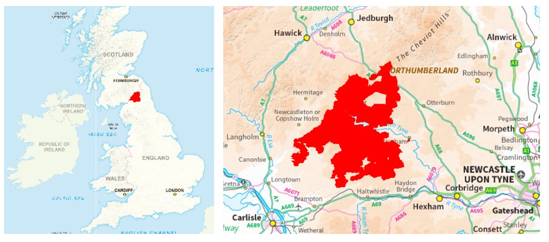
The Borderlands Research Forest contains some 34,723 hectares of woodland cover, of which about 92% is coniferous and 8% broadleaved. In addition there are around 18,500 ha of non-woodland terrestrial habitats including 6,500 ha of unimproved grassland, 5,800 of bogland, 1,200 ha of unplanted upland heath and 20 ha of wet woodland. Some 2,200 ha has been felled in recent years and is awaiting either replanting to woodland or restoration to other priority habitats. A further 2,900 ha of ground is under recreational, agricultural or nursery uses, mineral workings, or other types of built estate.
Post-glacial native woodland cover (dominated by oak, alder, birch and pine) is believed to have been progressively cleared between the Neolithic and Medieval periods and there is evidence of pre-historic field systems and enclosures, and of medieval settlements on the moors. The region was marked by local / border warfare during the 14th to 17th centuries, followed by a more settled period and climatic improvements leading to an increase in farming, sporting and mining uses. Historically, the moorlands had been managed at low intensity due to poor access, waterlogging, exposure and peaty soil types limiting agricultural use to grazing at lower stocking densities by hardier breeds of livestock.
The extensive moorlands surrounding Kielder Castle were first identified for spruce afforestation in the early 1920s by Roy Lister Robinson (later the 1st Baron Robinson of Kielder Forest), one of the first Forestry Commissioners. The objectives were primarily to create a strategic reserve of timber and to provide rural employment. Tree-planting commenced in 1926 and continued rapidly, with around 50,000 ha of forests having been established by the 1970s. The constraints of soil type and exposure resulted in a somewhat limited range of tree species being planted. During the later 20th Century landscape, environmental, biodiversity and recreation objectives became increasingly important.
Early afforestation was challenging due to waterlogging and the poor nutrient status of the moorland soils, so early efforts sought to identify appropriate cultivation, drainage and fertilising regimes. By the 1950s, over sixty experiments had been established. Direct-planting proved unsuccessful. Trials involving planting into upturned turfs and mechanical cultivation followed, with tractor-ploughing at 5-foot centres (1.5 m and 4,300 stems ha-1) and planting on ridge-tops becoming standard practice by the 1940s. The use of Sitka and Norway spruces proved successful, whilst Scots pine fared poorly (due to damage by black grouse!). Lodgepole and Corsican pines were also trialled, along with Douglas fir, other firs and larch species. First rotation plantings were found to benefit from applications of basic slag phosphate fertiliser, although later this was found to be less important when the same ground was replanted. Wider initial planting spacings were investigated and a standard stocking density of 2,500 stems ha-1 (via cultivation at 2.0 m centres) had been adopted by the 1970s, along with interim thinning at the lower elevations in order to encourage root-spread and improve wind-firmness. By this time, Sitka spruce had emerged as the most successful species at Kielder and accounted for 72% of the total forest area; the rest being mainly Norway spruce and lodgepole pine with minor areas of Scots pine or broadleaves.
The key findings of early research at Kielder between the 1920s and 1950s were that: i) that a raised planting position was required, ideally created by single-furrow ploughing along with a network of drains of 60-90 cm depth, ii) that spruces out-performed other species on purple moor grass-dominated sites, and that pine or sometimes larch species performed better on heather-dominated sites, and iii) that phosphate fertilisers were necessary on the poorer soils. Research during the latter parts of the 20th Century confirmed the need to control competing heather through the use of chemical herbicides, and that slow early growth could be enhanced by the use of additional potassium fertiliser on areas of deeper peat. This early research into upland afforestation at Kielder was invaluable in developing our modern understanding of matching species to soil and dominant vegetation types, particularly on sites dominated by heather, bracken, sedges, purple moor grass and mixed grassland.
Kielder Water, the largest man-made reservoir in the UK, was constructed between 1975 and 1981 and resulted in significant infrastructural improvements and an associated increase in forest recreation. Significant round timber production (mostly mechanised) from the forests at Kielder began in the early 1980s, achieving 380,000 m3 annum-1 from around 1,000 ha annum-1 of clear-felling by the mid-1990s. During the later 20th Century, there was increasing concern with regard to the effects of increased afforestation and grazing (particularly the associated drainage operations) on the important mire habitats. There has since been a reduction in grazing and burning, and the Forestry Commission has worked in partnership with conservation bodies on substantial and ongoing blanket bog restoration projects whilst increasing the areas of broadleaved woodland, particularly in riparian areas.
The Borderlands Research Forest is situated on an area of high, rolling plateau moorlands. The area rises from the south to a high natural ridgeline and the Cheviot Hills to the north and northeast, marking the border with Scotland. Around 95% of the area is higher than 200 m above sea level, the majority at between 200 m and 300 m, but with about one-third lying between 300 and 450 m. It falls within the Border Moors and Forests National Character Area (NCA): a large-scale, upland landscape of extensive, exposed heath moorland (uncultivated hill ground with peaty, acidic soils dominated by low-growing vegetation particularly heather), mire habitats (wet spongy earth, moss-dominated, usually occurring in depression ground) and unimproved, acid grassland, with large tracts of conifer forests. Wark Forest and parts of Redesdale Forest also fall within the Northumberland National Park.
The Research Forest area is dominated and is bisected by the North Tyne Valley, running northwest to southeast. The plantations are drained by a network of burns (fast-flowing streams with rocky beds), sikes (the uppermost sections of streams draining moor or marsh areas) and becks (small streams). The northern areas drain towards the River North Tyne, via Kielder Water. Those in the south drain to the River South Tyne, whilst those in the northeast drain to the River Rede. Kielder Water is an important supply for settlements in both the Tyne and Wear valleys, and the Kielder forests dominate much of the Tyne catchment area. The Kielder Forests are largely unaffected by Drinking Water Safeguard Zones, other than some minor areas of Redesdale Forest around Catcleugh Reservoir.
The Borderlands Research Forest falls within one of the wettest and coolest areas of England and Wales. The climate type is mild oceanic. Mean monthly temperature minima and maxima are about 2oC and 13oC. Mean annual rainfall increases with elevation; from around 1,000 mm on the lower ground to 1,400 mm at the higher elevations. Ground frosts are common, particularly in grassland areas. Wind-damage is a significant risk at these higher-elevation, relatively exposed locations and the mean windthrow hazard class (WHC) for Kielder Forest is 4.7 (on a scale of 1-6, with 6 representing the greatest risk). Accounting for modern cultivation and drainage techniques, the main limiting factor on tree growth is now wind, and this effect is more pronounced on areas of gleyed soils (lower permeability) and higher water tables. Traditionally, this has resulted in no-thin management regimes and clear-felling undertaken at ages 35-50.
Kielder Forest is located in the UK Meteorological Office’s England North Climate Region, straddling both the England East and Northeast, and the England Northwest and Wales North climate districts, and the Northeast England and the Northwest England & Isle of Man climate areas. The Research Forest benefits from two local weather reporting station; at Spadeadam to the southwest and at Redesdale to the northeast, enabling current and historical climate data to be compared regionally and nationally. The table below summarises and contrasts Met. Office data from 1991 to 2020 for the Kielder area and its respective climate districts and climate regions.
| Annual mean max. temperature (°C) | Annual mean min. temperature (°C) | Annual mean air -frosts (days) | Annual mean sunshine (hours) | Annual mean rainfall (mm) | Annual mean rainfall (days) | |
| Spadeadam Reporting Station | 11.04 | 4.28 | 73.02 | NA | 1302.52 | 181.84 |
| England Northwest & Wales North District | 12.66 | 5.79 | 47.71 | 1374.31 | 1337.91 | 169.91
|
| Redesdale Camp Reporting Station | 11.84 | 4.02 | 77.29 | NA | 940.76 | 158.61 |
| England East & Northeast District | 12.99 | 5.49 | 52.01 | 1492.78 | 793.05 | 133.80 |
| England North Region | 12.79 | 5.55 | 51.31 | 1433.03 | 985.89 | 147.36 |
| England Region | 13.82 | 6.12 | 45.15 | 1538.05 | 869.55 | 135.21 |
| England and Wales Region | 13.69 | 6.10 | 45.12 | 1520.22 | 950.81 | 140.38 |
| United Kingdom Average | 12.79 | 5.53 | 53.37 | 1402.61 | 1162.67 | 159.08 |
The Northumbrian forest blocks, on the eastern side of the research forest, are underlain by the Tyne Limestone Formation of the Carboniferous period; fine to medium-grained limestones, sandstones, siltstones and mudstones (shallow marine in origin). The higher ground to the north and northwest, and the western areas of Spadeadam forest include areas of the Fell Sandstone Formation, of the Carboniferous period; fine to coarse-grained sandstones and mudstones (of fluvial origin). Kershope Forest is mainly located on the Lyne Formation of the Carboniferous period; mudstones, siltstones, limestones and sandstones (fluvial and shallow marine in origin). The entire forest area is overlain by superficial deposits of Till (detritus from glacial ice and meltwater – largely responsible for the areas of gleyed soil), Alluvium (unconsolidated detritus deposited by watercourses) or Peat (accumulated, partially-decomposed, semi-carbonised vegetation).
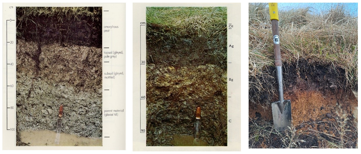
The moorlands lie at relatively high altitudes, and experience high rainfall and low temperatures which has resulted in the accumulation of peat deposits and development of extensive mire ecosystems. Soil types are largely of the peaty type: peaty surface-water gleys (left-hand photo), groundwater gleys (middle photo), ironpans (right-hand photo) and blanket or eroded bogs.
The forests at Kielder contain and are fringed by many sites of special scientific interest (SSSIs); notably for moorland, moss, mire, wetland and escarpment habitats. The region contains one of the largest upland moor / mire habitats in England and the Border Mires (Kielder-Butterburn) Special Area of Conservation (SAC): a large expanse of upland mire habitats (blanket bogs, marshes and heathland) which are of international importance.
The range and relative areas of trees by species and species group that are represented at the Borderlands Research Forest are shown in the table below. An additional 2,200 hectares of former woodland have been clear-felled and are currently await either restocking with trees, or restoration to other priority habitats. Further details of the location, age and area of individual stands of trees can be made available, upon request, if any of the species are of interest to you for study purposes.
| Scientific name | Area (ha) | ||
| Broadleaf | Birch (silver / downy, unconfirmed) | Betula pendula / pubescens | 300 |
| Birch, downy | Betula pubescens | 230 | |
| Rowan | Sorbus aucuparia | 148 | |
| Alder, common / native | Alnus glutinosa | 129 | |
| Willow, goat | Salix caprea | 56 | |
| Aspen | Populus tremula | 54 | |
| Birch, silver | Betula pendula | 45 | |
| Willow (other, unspecified) | Salix spp. | 25 | |
| Willow, grey | Salix cinerea | 23 | |
| Alder (other, unspecified) | Alnus spp. | 18 | |
| Chestnut, sweet | Castanea sativa | 10 | |
| Alder, grey | Alnus incana | 10 | |
| Hawthorn, various species | Crataegus spp. | 7 | |
| Oak (ped. / sessile, unconfirmed) | Quercus robur/petraea | 6 | |
| Sycamore | Acer pseudoplatanus | 6 | |
| Alder, red | Alnus rubra | 6 | |
| Beech | Fagus sylvatica | 4 | |
| Poplar, hybrid | Populus × canadensis | 4 | |
| Hornbeam | Carpinus betulus | 4 | |
| Cherry, wild / gean | Prunus avium | 3 | |
| Cherry, bird | Prunus padus | 3 | |
| Holly, European | Ilex aquifolium | 2 | |
| Hazel | Corylus avellana | 2 | |
| Poplar, black | Populus nigra | 2 | |
| Lime (small-leaved) | Tilia cordata | 1 | |
| Oak, sessile | Quercus petraea | 1 | |
| Ash (European, common) | Fraxinus excelsior | 1 | |
| Oak, pedunculate | Quercus robur | 1 | |
| Maple, Norway | Acer platanoides | 1 | |
| Elm (other, unspecified) | Ulmus spp. | 1 | |
| Oak, red | Quercus rubra | 1 | |
| Eucalypt (other, unspecified) | Eucalyptus spp. | 1 | |
| Mixed, or other ‘minor’ broadleaves: | 1,626 | ||
| Total broadleaf | 2,732 | ||
| Conifer | Spruce, Sitka | Picea sitchensis | 26,716 |
| Spruce, Norway | Picea abies | 2,754 | |
| Pine, lodgepole | Pinus contorta | 936 | |
| Pine, Scots | Pinus sylvestris | 739 | |
| Fir, Douglas | Pseudotsuga menziesii | 188 | |
| Larch, Japanese | Larix kaempferi | 147 | |
| Spruce, Serbian | Picea omorika | 145 | |
| Larch, hybrid | Larix × eurolepis | 84 | |
| Hemlock, western | Tsuga heterophylla | 34 | |
| Fir, noble | Abies procera | 27 | |
| Cedar, western red | Thuja plicata | 23 | |
| Spruce, Oriental | Picea orientalis | 17 | |
| Pine, Macedonian | Pinus peuce | 9 | |
| Fir, grand | Abies grandis | 9 | |
| Cedar, Japanese | Cryptomeria japonica | 7 | |
| Redwood, coast | Sequoia sempervirens | 5 | |
| Larch, European | Larix decidua | 3 | |
| Pine, mountain | Pinus mugo | 2 | |
| Cypress, Lawson | Chamaecyparis lawsoniana | 2 | |
| Cedar, Atlas | Cedrus atlantica | 1 | |
| Cypress, Leyland | Cupressus × leylandii | 1 | |
| Juniper, common | Juniperus communis | 1 | |
| Pine, Corsican | Pinus nigra (subsp. Laricio) | 1 | |
| Fir, Pacific silver | Abies amabilis | 1 | |
| Mixed, or other ‘minor’ conifers: | 140 | ||
| Total conifer | 31,991 | ||
| Total woodland | 34,723 | ||
The Kielder Forest blocks are managed by Forestry England (FE) as productive, multi-purpose forests incorporating a huge and very valuable timber resource. The woodlands are overwhelmingly coniferous and are heavily-dominated by Sitka spruce, which accounts for 77% of the current area of standing trees. Norway spruce covers around 8% and Scots and Lodgepole pines 5%, whilst Douglas fir, Japanese larches each account for about 0.5%. There are some minor areas of ancient, semi-natural woodland (ASNW) within the plantations. More than a third of the forest now comprises of younger, second rotation stands. In addition to other habitats and species of high conservation importance, the forests host the largest remaining population of red squirrels in England and are designated as the Kielder Red Squirrel Reserve. There are also extensive military training areas adjacent to Spadeadam and Otterburn.
Current management challenges for FE include the need to convert these extensive, even-aged conifer plantations into a more species and structurally diverse, wind-firm forest, whilst accounting for significant ecological, landscaping and recreation sensitivities. Through a programme of progressive felling and restocking, FE is introducing greater species diversity into the commercial timber crops, whilst also increasing the relative proportion of native broadleaved woodland. Wherever possible, clear-felling is planned in order to increase the age differences between adjacent plantation areas. Replanting is carefully designed to create more wind-firm boundaries, to avoid geometric outlines and straight edges to the plantations, and to make use of open space and lower-density planting in order to create a more gradual transition to open moorland. Where practical, lower-impact silvicultural systems with an emphasis on ‘continuous cover’ are being implemented, rather than traditional clear-felling. Here, elements of the older woodland are retained in order to provide a seed-source and shelter for the natural regeneration of seedlings or the under-planting of young trees beneath an existing canopy.
As a member of the Border Mires Management Committee, FE has restored some 2,000 ha of mire peatland and active raised bogs, which involved the removal of conifer plantations and drainage infrastructure and the creation of new ponds for wading birds. Through its current partnership with the Rewilding Britain charity, FE is working to make landscape-scale ecological enhancements to an area of around 6,000 hectares, located towards the northern end of Kielder Forest. Work is underway to diversify and expand the current woodland habitats by planting and encouraging the natural regeneration of native tree species, whilst restoring additional areas of peatland and improving hydrology, water quality and natural flood management at catchment-scale. Please see the links below to find out more about how FE is achieving the many environmental, social and economic objectives of modern forest management.
The Borderlands Research Forest is of great importance for modern climate-smart forestry research, as it represents a historical exercise in successful afforestation on challenging soil and habitat types that are representative of other upland sites where future woodland expansion may be considered. It must also sustain a critical role in supporting timber production and the regional economy, improving critical wildlife species and habitats, and supporting significant public recreational pressures. Forest Research continues to work in partnership with local managers particularly with regard to forest resilience, forest carbon and soil dynamics, species diversification, water quality, peat restoration and management of forests on bogs, and the use of remote-sensing and earth observation data in order to monitor forest growth rates and identification of pests and diseases.
Environment Agency. Surface Water Safeguard Zone Action Plan: Whittle Dene, SWSGZ6011 (internet, accessed August 2026)
Forestry England. Map of Kielder Design Plan Blocks (internet, accessed August 2026)
Forestry England. Kielder Forest Plans (internet, accessed August 2026)
Forestry England. Wild Kielder Project: A New Approach to Forestry (internet, accessed August 2026)
Joint Nature Conservation Committee. Border Mires (Kielder-Butterburn) Designated Special Area of Conservation (internet, accessed August 2026)
Lunn and Bill Burlton (2010). The Border Mires. A Conservation History. The Border Mires Committee
Meteorological Office. UK Climate Districts Map (website, accessed August 2026)
Meteorological Office. UK Climate Regions Map (website, accessed August 2026)
Meteorological Office. UK Regional Climate Summaries (website, accessed August 2026)
Meteorological Office. Redesdale Camp Location-Specific Long-Term Averages (website, accessed August 2026)
Meteorological Office. Spadeadam No. 2 Location-Specific Long-Term Averages (website, accessed August 2026)
Natural England. Border Moors and Forests National Character Area, description (website, accessed August 2026)
Northumberland National Park (website, accessed August 2026)
Northumberland Wildlife Trust. Wildwood Project (website, accessed August 2026)
Red squirrels Northern England. Red Squirrel Reserves and Strongholds (website, accessed August 2026)
Rewilding Britain. The Wild Kielder Project (website, accessed August 2026)
The Wildlife Trusts. Border Mires Peatland Restoration in Northumberland (website, accessed August 2026)
Visit Kielder. Support our Squirrels (website, accessed August 2026)
Zehetmayr (1954). Experiments in tree planting on peat. Forestry Commission Bulletin No. 22
UK Soil Observatory. Map Viewer. Soil Type, National Forest Estate (website, accessed August 2026)