BioCoRe: An interactive/adaptable landscape ecology approach for targeting restoration
Author(s): Andrew Rattey, Chloe Bellamy, Kevin Watts

Land use and ecosystem services (LUES)
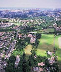
Andrew Rattey joined Forest Research in 2016. He has specialised in GIS and spatial data analysis in research covering a wide range of subjects including Ecosystem services, species distribution modelling and spatial modelling in R. More recently he has worked closely with SNH and the Glasgow and Clyde Valley Green Network Partnership to construct ecological networks and opportunity mapping data to help inform land management practices in central Scotland. He studied for a BSc (Hons) in Ecology at the University of Stirling and two MSc’s in Ecology and GIS, both at Aberdeen University.
Andrew provides GIS analytical support within the Land Use and Ecosystem Services programme. Areas of focus include the assessment of ecosystem services, species distribution mapping, ecological network modelling, and development of spatial models. Andrew works closely with other colleagues in different disciplines and with a wide range of researchers outside FR.
Author(s): Andrew Rattey, Chloe Bellamy, Kevin Watts

Author(s): Andrew Rattey, Chloe Bellamy, Duncan Ray, Kevin Watts, Shelley Kennedy, Russell Anderson, Darren Moseley
Author(s): Andrew Rattey, Chloe Bellamy
Summary In this paper the effects of climate and socio‑economic change on Scotland’s national forests are explored using 100‑year scenario…
Lead Author: Darren Moseley
The FOrest Biodiversity Index (FOBI) is a transparent, repeatable, spatially explicit indicator designed to monitor biodiversity potential across the UK’s…
Lead Author: Chloe Bellamy
This study develops a refined model for mapping oak woodland across Britain, significantly improving accuracy by integrating species distribution modelling…
Lead Author: Duncan Ray
Responsibilities
Current projects
Recently completed projects
Peer-reviewed papers:
Broome, A., Bellamy, C., Rattey, A., Ray, D., Quine, C.P. and Park, K.J., (2019) Niches for Species, a multi-species model to guide woodland management: An example based on Scotland’s native woodlands. Ecological Indicators, 103: 410-424. https://doi.org/10.1016/j.ecolind.2019.04.021
FC and FR publications and other reports
Broome, A., Rattey, A., Bellamy C., (2018), Niches for Species, a multi-species model to guide woodland management. Forestry Commission Research Note FCRN035.
Blogs, newsletters and other online content
Bellamy & Rattey (2018) ‘Story Map – harnessing the power of maps’ Forest Research News, February 2018.