Summary
Forest Research have worked with Wirral Council to undertake a study of the region’s tree population using i-Tree Eco.
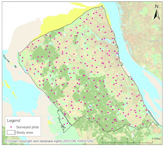
The study area covers the whole of the Metropolitan Borough of Wirral, covering an area of 15,700 hectares. 250 sample plots were distributed within a regular grid across the study area to ensure the sample was representative of the different land uses and characteristics present in Wirral. Details of ground cover, land use, shrubs, and trees were recorded in each plot. The i-Tree Eco software was used to extrapolate the field data to estimate the structure and composition of the whole tree population, and the ecosystem services the trees provide.
This study is the first i-Tree Eco project to include measures of social and cultural values of trees. The Urban Forest and Society and Environment research groups worked together to design a data collection methodology that uses data commonly collected during an i-Tree survey, and additional data variables to represent social and cultural values. These include:
- Public visibility of trees
- Public accessibility of trees
- Type of surface of access route to trees
As well as the tree survey, this project included an online questionnaire which was shared with people living in Wirral. The questionnaire asked people about:
- Perceptions of trees
- Preferences for trees
- Management of trees
- Action for trees
- Uses and values of trees
To capture information about the distribution of trees and the benefits they provide in different socio-economic regions in the study area, the sample was stratified according to the Index of Multiple Deprivation (IMD). This is a metric which is widely used to represent the relative deprivation of small areas. IMD is a single number combining seven different measures of deprivation:
- Income deprivation
- Employment deprivation
- Education, skills, and training deprivation
- Health deprivation and disability
- Crime
- Barriers to housing and services
- Living environment deprivation
The study area was divided into five levels of IMD (quintiles), with level 1 being the most deprived and level 5 being the least deprived. An appropriate number of plots was assigned to each quintile to ensure that enough data were collected to enable comparison of the tree population between quintiles.
Research Objectives
The aims of this project are:
- To gain a baseline understanding of the distribution and composition of Wirral’s tree population
- To value some of the ecosystem services provided by Wirral’s trees
- To gain understanding of the importance of Wirral’s trees to local people

Findings and Recommendations
Findings
It is estimated that there are more than one million trees in Wirral.
Wirral’s trees provide annual benefits worth £7.7 million per year.
Local people value trees because of their importance to wildlife, their contribution to mental and physical wellbeing, air pollution removal, and because they provide a connection to nature.
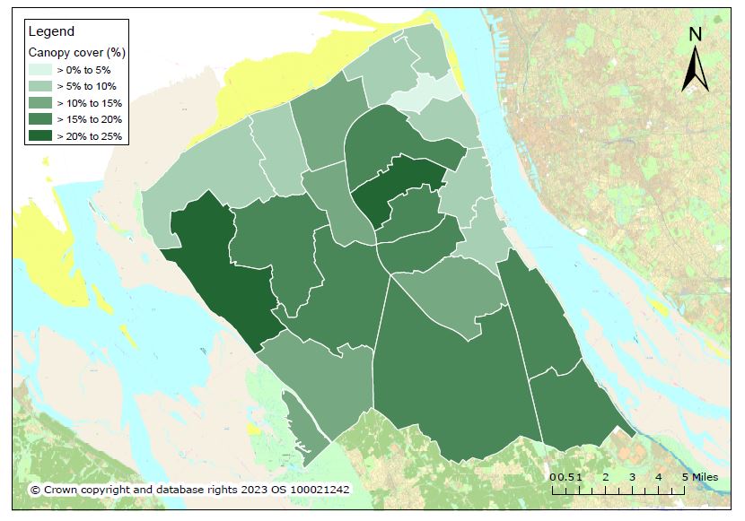
There are fewer trees, and lower provision of benefits, in more deprived areas of Wirral. People living in these areas would like to see more trees planted in their neighbourhood.
Recommendations
Equitable provision of benefits
Trees and the benefits they provide are not distributed equitably across Wirral. We recommend seeking out the voices of people who are less often heard, such as people living in more deprived areas. Increase planting, and therefore benefit provision, in areas that are lacking in canopy cover. Look to plant in areas with high deprivation and those which experience high air pollution, surface flooding, limited greenspace, or lack of shade.
Wide range of benefits
As well as planting trees for carbon storage and sequestration, consider the other benefits that trees can provide.
Structure
Large trees provide the greatest quantity of benefits. Retain large, mature trees wherever possible. Aim to make large, mature trees a part of new developments rather than removing and replacing them.
Trees in development
Use CAVAT to highlight amenity values of threatened trees to developers and communities, and to leverage compensation or sufficient replacement planting for amenity trees that are removed by developers. Set up community care schemes to encourage engagement by local people and help to ensure the good health of young trees. Take opportunities to create areas of accessible urban woodland to bring benefits to people in their day-to-day lives.
Planting
Protect and enhance tree cover on private land by engagement with local communities, businesses, and landowners. Tree planting on agricultural land has the potential to help Wirral meet its 2030 canopy cover target. Engage people in planting, caring for, and retaining trees in their gardens and recognising the value of garden trees as an important part of the urban forest.
Carbon storage and sequestration
Ensure the survival of existing trees to maintain the carbon storage and sequestration benefits they currently provide. Find long-term uses for dead or felled trees, such as standing deadwood, sculptures and carvings, street and park furniture, or seasoning as native hardwood for sale.
Pests and diseases
Establish a tree monitoring programme to give early warning of pests, diseases, and threats to Wirral’s trees. This could be in the form of a community engagement and involvement opportunity, the Tree Warden scheme, or a citizen science programme through Observatree.
Latest Update
In September 2023 a workshop was held with stakeholders from across Wirral, including public health professionals, planners, councillors, and tree officers. The results of the study were discussed, and participatory tasks enabled exploration of the values framework and the recommendations from the report.
Downloads

Funding & Partners
-
 Wirral Borough Council
 -
 Forest Research