Summary
Development of STORM resistant landscapes through regional co-operation, adapted management and RISK communication
Summary
 The countries situated around the North Sea have experienced forest wind damage throughout history. Severe storms in recent years have caused large scale disruption not just to forest industries, but also to the infrastructures of these countries, and climate change is expected to increase the frequency of these extreme events in the North Sea Region. Experiences and expertise on how to reduce windthrow in forest landscapes have developed differently in each country.
The aim of the STORMRISK project was to integrate and make accessible the knowledge and experience developed over decades to end-users in the North Sea Region.
Research objectives
There were four different activities within the project:
Future aims and ecological conditions for the forests and landscapes in the North Sea Region
Knowledge of past storm damage in the North Sea Region will be collected and various scenarios for the future climate in the Region will be examined. Available information on landowner and management aims as well as expected future trends were collected and disseminated. Two pilot study landscapes in storm damaged areas in Sweden were conducted in cooperation with landowners and other stakeholders.
Wind damage – general planning models and risk communication
The wind damage models, ForestGALES and Winda, were used to calculate the probability of stand scale wind damage in the pilot study areas. Information from running the models provided decision support to landowners.
Preventive management methods to reduce the risk of wind damage to natural and cultural landscapes
In order to give landowners, planners and managers options on how to create and manage their future landscapes, information on wind damage risk and alternative management methods was made easily accessible. Existing knowledge and information about forest wind damage, preventive management methods and restoration was gathered and evaluated. The information collected was evaluated by an expert group and transformed into a toolbox available via the project website.
Establishment of new sustainable forests and landscapes
Forest owners and managers were given advice and knowledge to assist them in responding to current and future challenges presented by the wind climate in the North Sea Region. The STORMRISK project provided a source of inspiration by demonstrating experiments on how to create sustainable forests and landscapes. This in combination with publications, excursions, and a web based “toolbox” based on all the project activities provided up-to-date information adapted to practical forestry.
Funders and partners
![]()
The STORMRISK project was part funded by the European Regional Development Fund through the Interreg IIIB North Sea Programme.
Partners:

Swedish Forest Agency Region Väst and Region Öst
Forest Research (see Tree stability and climate programme)
Forest and Landscape, Denmark
Chamber of Agriculture in Lower Saxony, Germany
Forestry Commission policy
Research on windthrow has been identified as a component of the UK Programme on Sustainable Forestry. Paragraph 3.28 states the aim:
“To promote better prediction of the onset of windthrow to optimise the returns from windthrow susceptible sites.”
This is consistent with priorities identified by other organisations such as Timber Growers Association (TGA), Home Grown Timber Advisory Committee (HGTAC) and the National Audit Office (NAO).
Forest Research activities in the STORMRISK project
These included release of a web-based version of ForestGALES that can be adapted for use in any part of the North Sea Region where wind data are available, and developing methods to map wind risk to forests at a landscape scale using remote sensing data from air-borne LiDAR.
Further information
The use of LiDAR remote sensing data for forest wind risk management was featured at the Silvilaser Conference in September 2008.
Status
The STORMRISK project started in 2006, and was completed during 2008.
Project results and documents are available at the project website.
Contact
Managing wind risk to forests in northern Europe
The STORMRISK project
In January 2005, a catastrophic storm damaged 85 million cubic metres of timber across northern Europe – ten times the annual production of UK forests. The STORMRISK project, funded by the EU through the Interreg North Sea Programme, was established to gather knowledge of managing forest wind damage, and to make it accessible to forest owners, managers and planners.
The project is a partnership of forestry companies and research organisations from Sweden, the UK, Germany and Denmark. Forest Research was invited to participate because of its experience in modelling and mitigating the effects of wind on forest stands.
Using the ForestGALES wind risk model
A version of Forest Research’s successful ForestGALES wind risk model can now be applied in other countries bordering the North Sea. This system can be accessed via the internet and calculates risk to forest stands based on local wind data and user-provided stand characteristics. Outputs include critical wind speeds expected to overturn trees, and the likely return period of such wind speeds.
During 2007, ForestGALES was applied at the landscape scale for a STORMRISK case study in Glen Affric, Scotland, using data from the Forestry Commission’s sub-compartment database to predict current and future risk (Figure 1). This risk assessment has since been used in the local design planning process.
To improve calculations of wind risk to stands with an uneven structure, and to develop a method of assessing risk using remote sensing data, Glen Affric has also been scanned using air-borne LiDAR (light detection and ranging). This technique uses laser pulses that can ‘see’ through forest canopy (Figure 2).
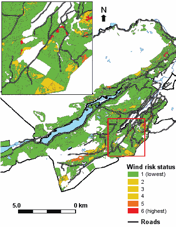
Figure 1
Geographic information system (GIS) map of wind risk in Glen Affric (areas at highest risk are shown in red)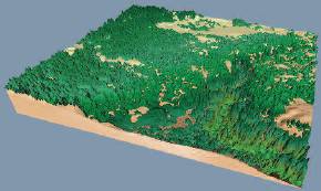
Figure 2
Three-dimensional view constructed from air-borne LiDAR data, showing a section of forest in Glen Affric
The resulting data were analysed to provide the tree dimensions required by ForestGALES. Development of this link between remote sensing data and ForestGALES provides a method for detailed assessment of wind risk in complex forest structures.
Impacts of a changing climate
Forest wind risk management must consider a changing climate. Predictions of climate change for northern Europe include an increased frequency of extreme wind events and increased rainfall. Together these are expected to increase the risk of windthrow over the next fifty years. Advice on management of forests for wind risk in a changing climate, based on experiences from each participating country in STORMRISK, as well as the latest developments in wind-risk modelling, is available in an online toolbox.