Summary
Summary
Climate scenarios published by UKCIP (2002) have been used to calculate climatic indices of climatic warmth and wetness for the future 30-year climatic periods centred on the years 2050 and 2080, for the low and high emissions’ scenarios.
The maps below show changes for the low and high UKCIP02 emissions’ scenarios. These maps represent the upper and lower range of UKCIP02 climate projections for Wales through this century.
Climatic warmth
Accumulated temperature (AT) is a measure of the degree of warmth for plant growth throughout the growing season. It is measured as the accumulated number of degrees over 5 ˚C each day of the growing season, and described in units of day-degrees over 5 ˚C. Plant growth begins at about 5 ˚C, and so in relatively cool climates (such as Wales) small increases in the mean daily temperature have a large effect on AT, and on plant growth. Over the past 40 years the mean temperature of Wales has increased by about 1 ˚C overall, with increases in each season leading to a longer and warmer growing season.
The climate change projections published by UKCIP (Hulme et al., 2002) for different emissions’ scenarios have been used to calculate AT for the future 30-year climatic periods centred on the years 2050 and 2080. The maps below show AT for the baseline climatic period (1961–1990) and projected for the 2050 Low- and High-emissions’ scenarios, and the 2080 Low- and High-emissions’ scenarios.
The 2050 maps show a projected general increase in AT, with a 40% increase for the warmest southern parts of the country, from 1800 to 2500 day-degrees.
By 2080 climate projections suggest further warming for both the Low- and High-emissions’ scenarios, with the possibility of a significantly warmer climate for tree growth in Wales. In parts of south Wales AT values for a High-emissions’ scenario are projected to be over 2500 day-degrees for large areas Wales at lower elevation, and might exceed 3000 day-degrees for parts of south Wales.
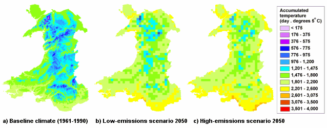
Accumulated temperatures calculated from baseline climate data and UKCIP02 Low- and High-emissions’ scenario projections for Wales in 2050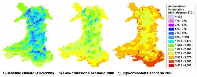
Accumulated temperatures calculated from baseline climate data and UKCIP02 Low- and High-emissions’ scenario projections for Wales in 2080
Climatic wetness
Moisture deficit (MD) is the maximum accumulated excess of evapotranspiration over rainfall in the summer months and is a good indication of water availability for plant growth. MD has been calculated for the climatic baseline period 1961–1990 and for the future 30-year climatic periods centred on the years 2050 and 2080.
The 2050 maps show projected MDs increasing in the south and eastern lowlands of Wales from baseline climate values of 180 mm to values in excess of 200–220 mm for the High-emissions’ scenario by 2050, and 180–200 mm for the Low-emissions’ scenario. As many forest soils hold only 150–180 mm of water that is accessible to plants, many woodlands in Wales are likely to experience more frequent summer drought, particularly in the south and east of Wales, independent of which global climate change scenario trajectory.
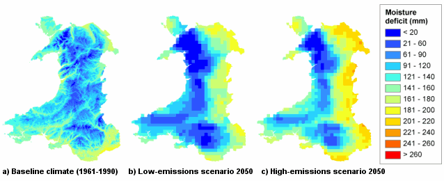
Moisture deficit calculated from baseline data and UKCIP02 Low and High-emissions’ scenario projections for Wales in 2050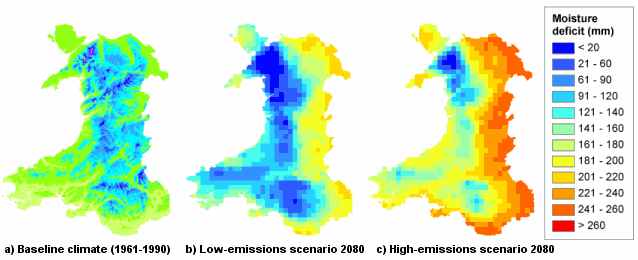
Moisture deficit calculated from baseline data and UKCIP02 Low and High-emissions’ scenario projections for Wales in 2080