Summary
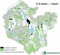
Map showing high priority areas for floodplain, riparian and wider woodland planting to reduce downstream flooding in the Upper Derwent catchment, Cumbria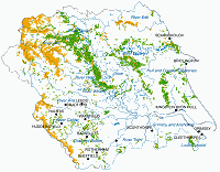
High priority areas with the greatest potential for woodland planting to reduce downstream flooding in the Yorkshire and the Humber region
There is growing evidence that strategic tree planting and woodland management can help reduce flood risk.
Recent projects, in the Lake District National Park and Yorkshire and the Humber region, have used GIS and spatial data sets to identify areas where woodland establishment has the greatest potential to reduce flooding.
- Opportunity mapping for woodland to reduce flooding in the River Derwent, Cumbria (PDF-4193K)
Final Report July 2010 - Opportunity mapping for woodland creation to reduce diffuse sediment and phosphate pollution in the Lake District (PDF-4969K)
Final Report July 2010 - Opportunity mapping for woodland to reduce flooding in the Yorkshire and the Humber region (PDF-6947K)
Final report to Forestry Commission England, March 2009
Forest Research Monograph: 1 - Opportunity mapping for trees and floods (PDF-1847K)
Final Report to Parrett Catchment Project, Wet Woodland Group, December 2003
The maps identify priority areas for three types of woodland that can contribute to flood management:
- Riparian planting in the upper catchment
- Wider catchment planting, in particular in areas of high risk soils
- Floodplain woodland
The opportunity maps consider topography, soil type, land use, conservation and heritage value and will be used by regional stakeholders to promote the use of woodland in sustainable flood management. Grant aid will be targeted to areas offering the greatest potential benefits to flood alleviation.
In the Lake District erosion, caused by over-grazing, land cultivation, drainage and human trampling, has resulted in soil loss and excessive sedimentation of watercourses, leading to local increases in flood risk and damage to important habitats and several freshwater priority species. The Forestry Commission (FC), Cumbria Woodlands, the National Trust, The Woodland Trust and Natural England, have come together in joint initiatives to address issues such as water quality, soil erosion and flooding across the National Park. As part of this work, Forest Research has created maps for Lake District National Park that identify land with vulnerable soils at risk from hill slope and stream bank erosion, where woodland creation has the potential to reduce diffuse pollution and improve water quality.
In the Yorkshire and Humber region the priority areas identified in the mapping project were targeted for additional grant aid from the Yorkshire Forward Renaissance programme to promote woodland creation in areas that offered the best potential for flood mitigation. The region was selected as a £700,000 DEFRA funded pilot project to assess how land management, including tree planting, can reduce flood risk in the Pickering and Sinnington areas.
A pilot study in the Parrett catchment aims to demonstrate how the reversion of arable land to woodland, in the mid and upper catchment, will increase soil water retention and reduce surface runoff. A native broadleaved riparian woodland has been created in a previously arable field in the floodplain of the River Parrett. The trees were planted with the support of the Foresty Commission under the Woodland Grant scheme and farm Woodland Premium Scheme.
At present, the available grant schemes do not match all the woodland implementation costs and the farmer is expected to meet the difference, in some cases this can be a substantial sum. Where these investments are for flood defence purposes and largely for the public good, landowners may be reluctant to make this contribution and the take-up may be small.