About Thetford Chase Research Forest
Find out more about the Thetford Chase Research Forest and how its distinctive landscape, climate and long history of forestry research are helping develop more resilient forests for the future.

Explore Thetford Chase’s distinctive history, climate, geology, soils and woodland structure to understand how this extensive natural resource supports modern forestry research and is helping us to understand how to adapt management techniques to a changing climate and help create resilient future forests that deliver a wider range of environmental and societal benefits.
Thetford Chase contains the UK’s largest area of lowland plantation forestry, which is of relatively recent origin and is England’s second largest productive conifer forest. These woodlands have been successfully established and managed in one of Britain’s most challenging regions in respect of climate extremes (low rainfall, high drought-risk), soil conditions (low water-holding capacity, strongly acidic or strongly alkaline, with low organic content) and emerging tree pathogens (particularly Dothistroma septosporum).
The Thetford Chase Research Forest comprises of 21 individual woodland blocks surrounding the towns of Brandon and Thetford, straddling the border between the two East Anglian counties of Suffolk and Norfolk. Covering more than 20,000 hectares, it includes the core woodlands often referred to as ‘Thetford Forest’ and extends northwards to Shouldham and West Bilney, eastwards to Banham, and southwards to Mildenhall and the King’s Forest.
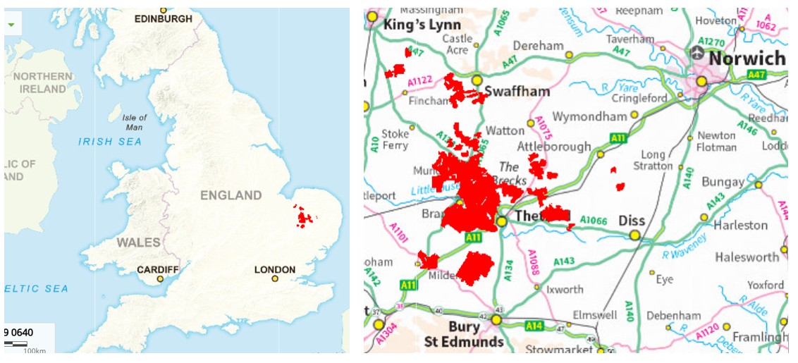
Thetford Chase includes around 17,000 ha of woodland cover and some 2,300 ha of non-woodland terrestrial habitats, with more minor areas of agricultural land, open water, recreational sites, built estate, mineral workings and felled forest sites awaiting replanting. Forest Research maintains a local presence at the Thetford Field Station (National Grid reference TL 815 879), located close to Santon Downham. From here, the FR Field Data Services Team undertakes terrestrial and aerial forest survey works, whilst providing expert support for the establishment, maintenance and assessment of many field trials.
‘Breckland’ is a medieval term for relatively infertile, gorse-covered heathland (believed to originate in Neolithic period forest-clearances and settlement) that was maintained through warrening and grazing, being occasionally broken-up by short rotations of arable farming (i.e. a break or ‘breck’), before reverting back to nature following nutrient-depletion. The landscape was developed into larger sporting estates and farms during the 18th Century, creating large-scale field systems enclosed by hedges and shelterbelts of Scots pine and beech. Financial hardships for farmers and landowners following the First World War resulted in substantial areas of land being bought or leased by the British state for afforestation and military areas.
The woodlands of Thetford Chase were established rapidly by the Forestry Commission during the 1920s and 1930s. Extensive local research was required for this unprecedented scale of lowland conifer afforestation, accounting for the famously arid Breckland soils and local tree pests and pathogens. Experimental work began around 1927 with a series of trials of species, provenances, plant types, nursing mixtures and methods of ground-preparation and planting. Scots pine, Corsican pine (which was less affected by pine shoot moth) and birch emerged as the most suitable species. Beech, poplars, Douglas fir, larch and spruces initially proved less successful, although results were mixed. It soon became necessary to reduce the size of conifer plantations as a fire-protection measure, including the use of broadleaved fire-breaks. Production of round timber grew steadily during the mid-20th Century, peaking and stabilising in the 1990s at around 200,000 m3 per annum. National forest policy changes during the mid-to-late 20th Century introduced more multi-purpose objectives for to improve the wider social, economic and ecological benefits from woodland management.
The woodlands at Thetford Chase are located mainly within a very large area of central East Anglia designated as the Brecks National [Landscape] Character Area (NCA) and also the Breckland Special Area of Conservation (SAC). The outlying forest blocks at Shouldham and West Bilney lie in the Northwest Norfolk National Character Area, whilst the newly-planted woodlands near to Banham fall within the South Norfolk and High Suffolk Claylands National Character Area. Breckland rises from the marshy Fenland Landscape Area to the west forming a gently-undulating, low-lying plateau that rises slightly to the north. Slopes at site-level are generally negligible. Elevations range from 6 metres to 56 m, with the majority of ground lying at between 15 m and 46 m above sea-level. The plateau and has an open aspect on all sides but is mainly exposed to the north and east.
Significant rivers are the Little Ouse (between Brandon and Thetford), the Rissey (north of Thetford Forest), the Nar (north of Shouldham and Swaffham), and the Lark to the south of Mildenhall and the King’s Forest. Each of these flows westwards towards Fenland. Other valleys and depressions within the area largely appear dry and there is significant percolation to the underlying chalk and clay. The important Chalk Aquifer underlies Breckland and supplies much of East Anglia with drinking water. All areas of Thetford Chase fall with nitrate-vulnerable and / or drinking water safeguarding zones.
Thetford Chase falls within the UK Meteorological Office’s England South Climate Region, the Eastern England Climate Area and the East Anglia Climate District. The Research Forest benefits from a local meteorological station at Santon Downham, enabling current and historical climate data to be compared regionally and nationally. The table below summarises and contrasts Met. Office data from 1991 to 2020 for Thetford Forest, the East Anglia District and the England South Region. Thetford Chase falls within the warmest, driest area of southern Britain. There are frequent, severe and prolonged periods of drought and a very high incidence of frosts, which are often severe during spring and can also occur in early summer. There are also very high levels of atmospheric nitrogen deposition locally.
| Annual mean max. temperature (°C) | Annual mean min. temperature (°C) | Annual mean air -frosts (days) | Annual mean sunshine (hours) | Annual mean rainfall (mm) | Annual mean rainfall (days) | |
| Thetford Forest | 14.95 | 5.26 | 72.45 | 1526.67 | 666.25 | 120.52 |
| East Anglia | 14.59 | 6.46 | 42.15 | 1616.55 | 626.94 | 115.84 |
| England South | 14.36 | 6.42 | 41.90 | 1593.61 | 808.00 | 128.78 |
| England | 13.82 | 6.12 | 45.15 | 1538.05 | 869.55 | 135.21 |
| England and Wales | 13.69 | 6.10 | 45.12 | 1520.22 | 950.81 | 140.38 |
| United Kingdom | 12.79 | 5.53 | 53.37 | 1402.61 | 1162.67 | 159.08 |
With the exception of the Shouldham and West Bilney blocks to the north-west of the area (on sandstones with little superficial geology), the Thetford Chase Research Forest is almost entirely underlain by solid, sedimentary chalk formations of the Cretaceous period. In the Breckland areas this chalk generally lies close to the surface, with frequent superficial deposits of fine, windblown sand (which are sometimes very deep) and some flint. In the Clayland areas, where two Coronation woodlands have recently been planted near Banham, the underlying chalk is overlain with thicker accumulations of river gravels, lake sediments and glacial till or outwash comprising of chalky boulder-clay, silt, sands and gravels.
The soil types across the majority of the area of the Research Forest are argillic brown earths (moderately acidic, freely-draining, characterised by downward migration of clay particles) or calcareous brown earths (well-drained, fertile and characterised by free calcium carbonate and high pH). There are some localised areas of podsolised, gleyed or very sandy soils. These Breckland soils are generally sandy, free-draining, arid, of mixed fertility (low to lime-rich) and have low water-holding capacity. The outlying woodlands at Shouldham and West Bilney include areas of typical brown earth often referred to as Good Sands soils (freely-draining, sandy, slightly acid, fertile and versatile) and some ground-water gley soils (naturally wet, sandy / loamy, very acid, very low fertility). The new woodlands at Banham are planted on ex-arable sites with surface-water gley soils, characterised by heavy, chalky clay and seasonal waterlogging.
The range and relative area by species of broadleaved and coniferous trees represented across the Thetford Chase Research Forest is shown in the table below. Around 674 hectares has been felled and currently awaits restocking with trees or restoration to other priority habitats. Further details of the location, age and area of individual stands of trees can be made available, upon request, if any of these species are of interest to you for research purposes.
| Scientific name | Area (ha) | ||
| Broadleaf | Beech | Fagus sylvatica | 803 |
| Birch (silver / downy) | Betula pendula/pubescens | 775 | |
| Oak (pedunculate / sessile) | Quercus robur/petraea | 584 | |
| Sycamore | Acer pseudoplatanus | 229 | |
| Poplar, hybrid | Populus × canadensis | 160 | |
| Alder (other, non-native) | Alnus spp. | 85 | |
| Chestnut, sweet | Castanea sativa | 70 | |
| Ash (European, common) | Fraxinus excelsior | 50 | |
| Lime (small-leaved) | Tilia cordata | 29 | |
| Lime (other species) | Tilia spp. | 26 | |
| Hazel | Corylus avellana | 17 | |
| Maple, Norway | Acer platanoides | 15 | |
| Alder, Italian | Alnus cordata | 11 | |
| Oak, red | Quercus rubra | 11 | |
| Alder, common / native | Alnus glutinosa | 11 | |
| Hawthorn, various species | Crataegus spp. | 11 | |
| Eucalypt, various species | Eucalyptus spp. | 10 | |
| Mixed / other minor BLF | 109 | ||
| Total broadleaved | 3,005 | ||
| Conifer | Pine, Corsican | Pinus nigra (subsp. Laricio) | 8,132 |
| Pine, Scots | Pinus sylvestris | 3,518 | |
| Fir, Douglas | Pseudotsuga menziesii | 924 | |
| Cedar, western red | Thuja plicata | 239 | |
| Larch, hybrid | Larix × eurolepis | 192 | |
| Larch, European | Larix decidua | 142 | |
| Fir, European silver | Abies alba | 105 | |
| Cedar, Japanese | Cryptomeria japonica | 98 | |
| Fir, grand | Abies grandis | 92 | |
| Redwood, coast | Sequoia sempervirens | 66 | |
| Pine, maritime | Pinus pinaster | 54 | |
| Pine, Macedonian | Pinus peuce | 48 | |
| Hemlock, western | Tsuga heterophylla | 48 | |
| Larch, Japanese | Larix kaempferi | 45 | |
| Wellingtonia / giant sequoia | Sequoiadendron giganteum | 39 | |
| Spruce, Serbian | Picea omorika | 36 | |
| Fir, Nordmann / Caucasian | Abies nordmanniana | 30 | |
| Cedar, Atlas | Cedrus atlantica | 29 | |
| Cypress, Leyland | Cupressus × leylandii | 28 | |
| Cypress, Lawson | Chamaecyparis lawsoniana | 21 | |
| Spruce, Oriental | Picea orientalis | 20 | |
| Spruce, Norway | Picea abies | 14 | |
| Pine, lodgepole | Pinus contorta | 12 | |
| Pine, Weymouth | Pinus strobus | 12 | |
| Pines, other | Pinus spp. | 21 | |
| Firs, other | Abies spp. | 12 | |
| Mixed / other minor Conifer | 4 | ||
| Total conifer | 13,980 | ||
| Total Woodland | 16,985 |
The Thetford Chase woodlands are largely coniferous and are dominated by Pinus species, particularly Scots pine (19%) and Corsican pine (48%) which during recent years has been heavily affected by Dothistroma needle blight. Given the additional and unprecedented stresses of climate-change, this has created an urgent need to diversify the forest using a wider choice of genera and species. Traditionally, the plantations around Thetford have been managed under a clearfell and replanting system, with rotations of around 60 years. This has resulted in predominantly even-aged woodland structures which may increase vulnerability to modern climatic, insect and pathogen threats.
Through its long-term forest planning system, Forestry England (FE) is currently transforming the Thetford Chase woodlands to improve wildlife habitats and increase biodiversity, whilst continuing to deliver important commercial and recreation management objectives. FE is greatly reducing traditional levels of clear-felling and replanting woodlands in favour of lower-impact silvicultural systems, where substantial elements of the older woodland is retained to provide a seed-course and shelter for natural regeneration of seedlings or under-planted trees.
Thetford Chase is of great importance for modern climate-smart forestry research, since it sits at the extreme frontier of England’s changing climate and is at high-risk from pests and diseases. It must also sustain an important role in supporting timber production and the local economy, critical wildlife species and habitats, along with high recreational-use pressures. Much of the current research focus is addressing the topic of species and structural diversification, aiming to support forest managers and maintain forest resilience.
British Geological Survey. Aquifer Occurrence Maps (website, accessed July 2026)
British Geological Survey. Geology Viewer (website, accessed July 2026)
Forestry Commission (1952). History of Thetford, King’s and Swaffham Forests 1923-1952. Forestry Commission, East England Conservancy
Forestry England. Thetford Forest Resilience Project: Strategic Plan (website, accessed July 2026)
Historic England (2020). Farmstead and Landscape Statement Breckland National Character Area 85 (accessed July 2026)
Joint Nature Conservancy Council. Breckland, Designated Special Area of Conservation (website, accessed July 2026)
Macdonald (1939). Thetford Chase, With Notes On Swaffham Forest And The King’s Forest. Forestry, vol.13, pages 1–18
Meteorological Office. Eastern England: Climate Area Summary (website, accessed July 2026)
Meteorological Office. Santon Downham Location-Specific Long-Term Averages (website, accessed July 2026)
Meteorological Office. UK Climate Districts Map (website, accessed July 2026)
Meteorological Office. UK Climate Regions Map (website, accessed July 2026)
Natural England. National Character Area Profiles (website, accessed July 2026)
Thetford Forest, Forestry England (website, accessed July 2026)