 There are many different types of greenspace. When considered collectively as a wider green infrastructure, they can create an extensive and powerful recreational, cultural and community facility, improving environmental quality and health, as well as providing diverse and species-rich habitats. The term ‘urban forest’ is often used to describe greenspace that brings all the benefits of the natural environment to the heart of urban communities.
Types of greenspace include:
- Community woodlands
- Green roofs
- Landscape around buildings
- Street trees
- Urban parks and gardens
- Wetlands
Community woodlands
Somewhere on the sliding scale from dark green ancient semi-natural woodland to bright grey urban town centres, the community woodland is more than an attractive fringe greenspace abridging town and country.
Community woodlands deliver an array of social, economic and environmental benefits when appropriately located, designed and maintained. Improving neighbourhood appeal and community liveability, community woodlands also provide a place for recreation and a place for wildlife. Design is all-important – the right (native) tree in the right place, open sweeping pathways with good visibility ahead, and a mix of grassland, wildflower meadow and stands of trees, community woodlands offer a little something to everyone.
A number of organisations have been involved with developing and managing community woodlands, often as part of regeneration programmes to improve the quality of life in deprived areas, Successful sites have been found to involve the community in all stages of the planning and management process, to provide greenspace for social interaction and community cohesion and provide an area of which the community is proud.
The Forestry Commission has been involved in developing and managing a number of community woodlands, including:
- Thames Chase community woodland
- Bentley community woodland
- Kiveton community woodland
- Hill Holt Wood
- Brodsworth community woodland
- Dinnington community woodland
- St Helen’s
- The Western Isles community woodlands
- Salford and Bury
Green roofs
Green roofs are vegetated layers that sit on top of the conventional waterproofed roof surfaces of a building. Green roofs are designed to be sustainable and have a number of benefits for the environment. Green roofs:
- Conserve energy
- Improve the lifespan of roofs
- Provide sustainable urban drainage, thereby reducing flooding
- Provide a shelter for wildlife
- Improve air quality
- Provide noise abatement
- Mitigate climate change.
Whilst green roofs come in many different forms and types, usually a distinction is made between intensive, extensive and biodiverse roofs.
Intensive roofs
These are composed of deep substrates of over 20 cm in depth and can support a wide range of plants and vegetation type. They are generally heavy and require a large amount of support from the building.
Extensive roofs
These are composed of lightweight layers of free-draining substrates that support drought tolerant plants. The depth can be only a few millimetres with a maximum of 10-15 cm. These roofs have a potential for widespread use due to needing a lack of support from the building.
Biodiverse roofs
These are designed to replicate a habitat for a specific species, or to create habitats that maximise the number of species that can inhabit and use the roof.
Further information about green roofs can be found at Living Roofs and Walls: Technical Report Supporting London Plan (PDF-2580K) and Living roofs.
Landscape around buildings
Landscape around buildings should be designed to include green infrastructure such as tree planters, ponds, grass and lawn areas, green roofs and sustainable urban drainage systems (SUDS).
The green space that is incorporated in the landscape around buildings in urban areas can provide a number of benefits:
- The planting of trees next to buildings can provide shading and cooling and thereby reduce the need for air conditioning in summer months, and can provide shelter from winds and reduce heating requirements in winter
- The provision of aesthetically pleasing green space can encourage people to take part in recreation and exercise thereby improving health and well-being
- Views of green space from offices have been shown to improve concentration and work productivity, and reduce recovery time of patients in hospitals
- Improved landscape quality through green space can promote investment and attract companies to an area which leads to economic regeneration of deprived or neglected areas.
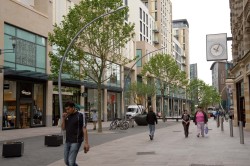
Street trees
Planting trees in urban areas has a number of environmental, social and ecological benefits. Street trees:
- offer cooling effects due to shading and evapo-transpiration from the canopy;
- help to improve air quality due to production of oxygen and absorption of air-borne pollutants such as polycyclic aromatic hydrocarbons (PAHs) and by mitigating carbon emissions;
- improve aesthetics and quality of place;
- improve human health and well-being; and
- encourage biodiversity due to provision of habitats.
Further indirect benefits include the reduction in buildings’ energy use due to reduced need for air conditioning in summer, and reduction in heating in winter due to sheltering buildings from sun and wind.
The tree species that are chosen for urban areas all exhibit characteristics associated with urban suitability, such as tolerance of harsh conditions. All tree plantings are site specific, and careful species selection represents a fundamental part of any good urban forestry project.
There are a number of street tree planting schemes across the UK.
Urban parks and gardens
It is estimated that, every year, well over half the UK population – some 33 million people – visit an urban greenspace more than once a week. And 91% of the UK population agree that the quality of such public spaces directly affects their quality of life.
Public urban parks and gardens are open to all, regardless of ethnic origin, age or gender. They are a place for recreation and leisure; they give a sense of identity to a place; and they represent a democratic forum for citizens and society.
While there are no definitive national or local standards for the number of parks and gardens provided, some local authorities promote a standard of 0.6 hectares per 1000 population, and that this should be available within a 15-minute walk.
Quality urban parks and gardens are an important component of every day life in towns and cities. So their design is worthy of careful consideration, and their maintenance is worthy of investment.
Wetlands
A wetland is an area of land on which water covers the soil, or is near the surface of the soil, at all times of the year or at various periods during the year. There are several ways in which to categorise wetlands, for example:
- Marshes or swamps: areas where water is more or less permanently at the surface and causes saturation of the soil (e.g. peatlands)
- Shallow lakes: areas of permanent or semi-permanent water with little flow (e.g. ponds)
- Coasts: areas between land and open sea that are not influenced by rivers (e.g. shorelines and beaches)
- Estuaries: where rivers meet the sea and water changes from fresh to salt as it meets the sea (e.g. tidal mudflats and salt marshes)
- Floodplains: areas next to the permanent course of a river that extends to the edge of the valley (e.g. ox-bow lakes and river-islands).