The FOrest Biodiversity Index (FOBI) tool
Learn about the Forest Biodiversity Index (FOBI), a new tool to monitor, report and enhance biodiversity potential in UK forests over time.
In response to the global biodiversity crisis, several targets and commitments have been drawn up to help track progress towards protecting and enhancing forest biodiversity. However, landowners and forest managers often lack the necessary information and tools with which to evidence progress towards these obligations and justify decisions.
One major challenge in monitoring and reporting biodiversity trends is finding indicators that are scalable, repeatable and easy to interpret, while also capturing the complex and multi-dimensional nature of biodiversity. To address this challenge, Forest Research (FR), Forestry & Land Scotland (FLS) and Forestry England (FE) have collaboratively developed the Forest Biodiversity Index (FOBI).
The FOBI co-development process and its application to state-owned forests in England Scotland are described on the FOBI research project page. Below we outline the features of the FOBI and current work to translate the approach to all forests in Britain.
The FOBI provides a quantitative, transparent and repeatable method for mapping and monitoring the biodiversity potential of our forests. It incorporates proxies of biodiversity that characterise the trees and structures within woodlands, and features of the landscapes surrounding them, such as tree age diversity, open habitat cover, and woodland connectivity.
These indicators, or ‘FOBI metrics’, have generalisable associations with woodland biodiversity evidenced in the literature that tend to hold true across different woodlands and contexts.
For example, we know that higher tree age or size diversity are typically positively related to other facets of woodland biodiversity, such as genetic or species diversity. Unlike taxonomic or trait-based biodiversity indicators, these structural metrics of ‘biodiversity potential’ are generally:
To encourage the use and communication of the results by decision makers, politicians and the public, the metrics are combined to provide headline measures of biodiversity potential.
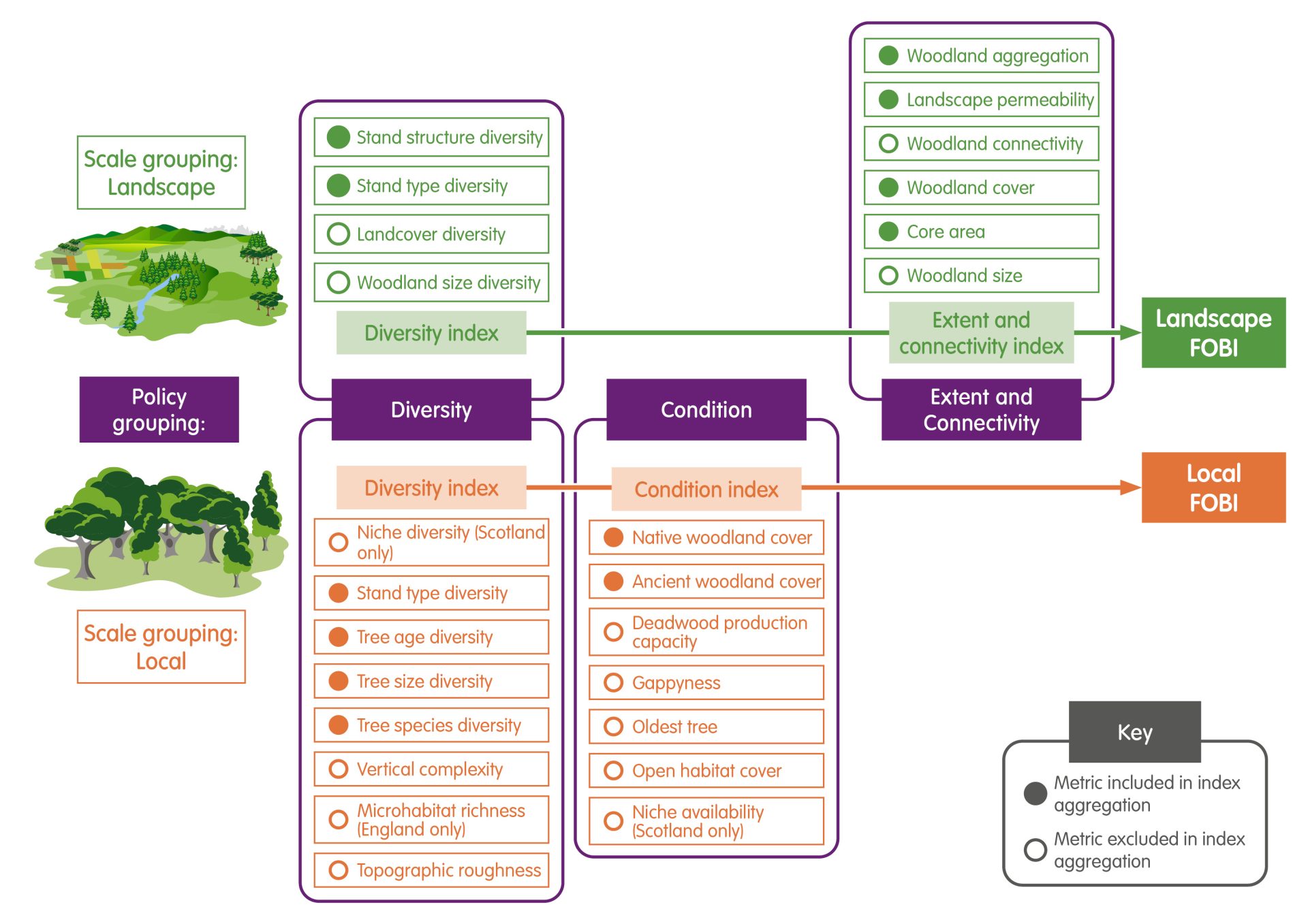
The FOBI expert group iteratively co-developed and refined a stepped approach that groups the metrics by the scale at which they are measured (local, ‘within woodland’ metrics and landscape, ‘surrounding woodland’ metrics) and their theme (diversity, condition, extent, and connectivity). A Local and a Landscape FOBI are provided at the highest level of the FOBI.
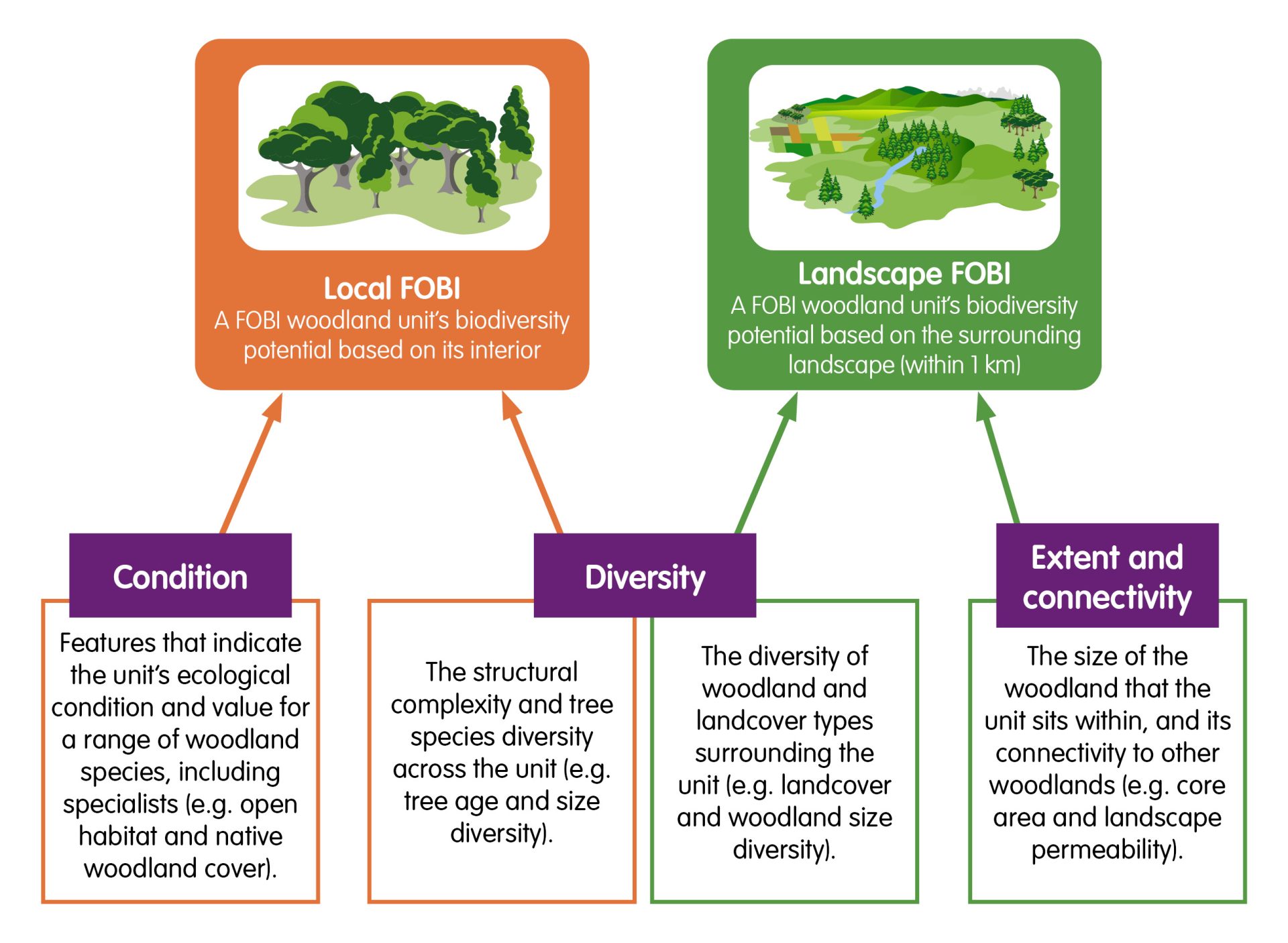
As the combination of multiple measures into a ‘composite index’ can be statistically problematic and provide misleading results, only positively correlated metrics are grouped following best practice guidance. Although this reduces the complexity captured, all levels of the FOBI, including the full set of metrics and the resulting composite indices, are provided to end users.
The layered and scalable outputs therefore provide for both strategic decision-makers requiring high level information for regional- to national-level reporting, and for forest planners and managers that require woodland-level metric information for spatially targeted management.
The FOBI approach was originally co-developed and applied to state-owned forests in England and Scotland by FR, FE and FLS. These forests account for around a quarter of woodland area in the United Kingdom.
The State-FOBI is measured for every ‘FOBI woodland unit’, which are groups of adjacent sub-compartments, or stands, falling within the same management zone. Many of the State-FOBI metrics are directly measured from the ‘subcompartment database’, a continually maintained, stand-level forest survey database. Others are modelled or derived from other spatial environmental datasets. The same outline approach is applied to England and Scotland, however the metrics calculated diverge slightly due to data availability.
More information on the co-development and application of the State-FOBI are provided on the FOBI research project page and open access journal paper (Bellamy et al., 2024).
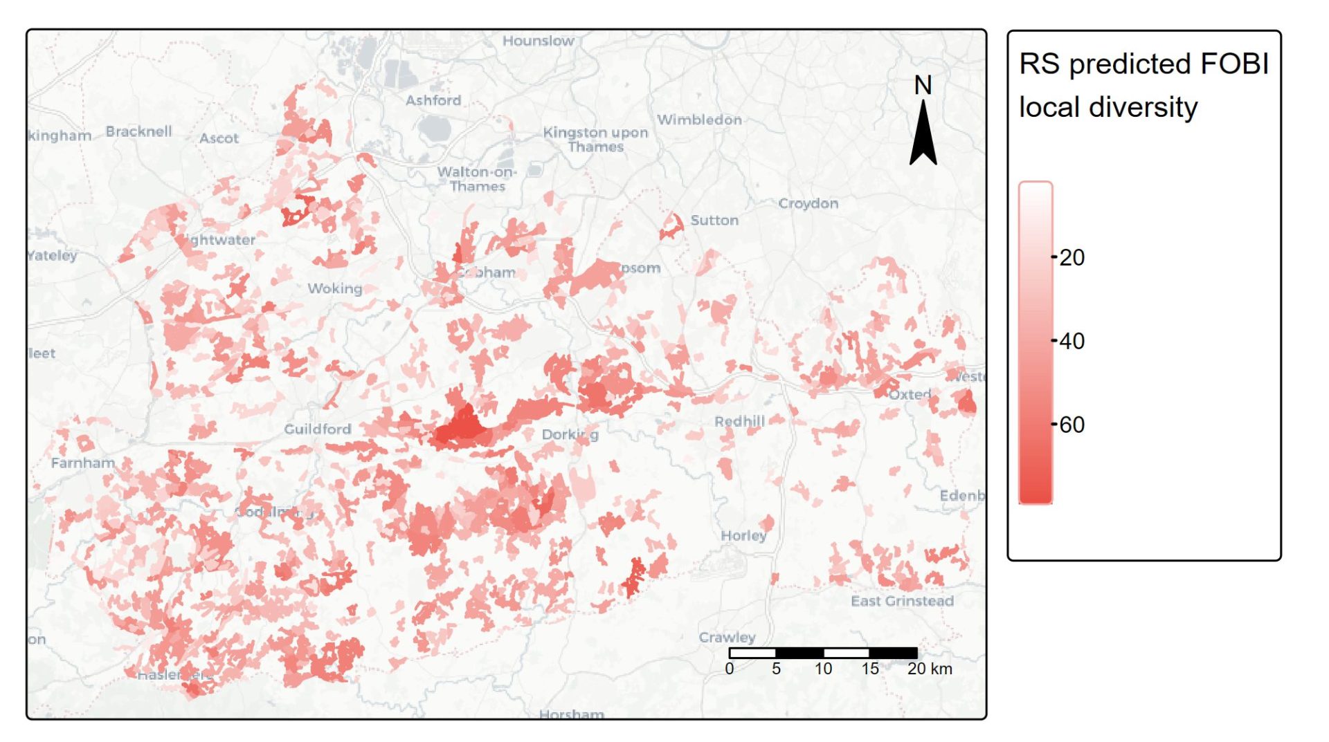
We are currently collaborating with several forest owners to explore how the FOBI approach can be applied to private forests. In the absence of the sub-compartment database used for calculating the State-FOBI, we are assessing the feasibility of using remote sensing data alongside survey data from private forest owners.
Compared to other forest biodiversity indices, the FOBI meets all the following criteria:
If you have questions, or if you would like to explore application of the FOBI to your forests, please get in touch with chloe.bellamy@forestresearch.gov.uk.
More details on the FOBI approach and results of the State-FOBI are provided in an open access journal paper and supplementary material: Bellamy, C.C., Rattey, A., Edwards, C., Kortland, K., Stringer, A., Tew, E., Bathgate, S., Kerecsenyi, N., Moseley, D., Watts, K. and Broome, A., 2024. The forest biodiversity index (FOBI): monitoring forest biodiversity potential over space and time. Environmental Research: Ecology.
Funding for this work is provided by Forestry and Land Scotland, Forestry England and the Forestry Commission – Innovation Strategy research program 5, 2021-2026.
This project is co-funded by Forestry and Land Scotland, Forestry England and Forest Research.