Summary
State-owned forests account for around a quarter of woodland area in the United Kingdom. The public forest agencies managing these forests are legally required to conserve and enhance biodiversity. To help evidence progress towards these obligations, and to inform strategic decision-making in support of biodiversity, FR, FE and FLS co-developed the Forest Biodiversity Index (FOBI) approach.
This webpage outlines co-development of the FOBI approach and its application to state-owned forests in England Scotland (the ‘State FOBI’). The features of the FOBI and current work to translate the approach to all forests in Britain (‘All_FOBI’) are described on the FOBI tool.
Research Objectives
To co-develop an index that meets Forestry England and Forestry and Land Scotland needs
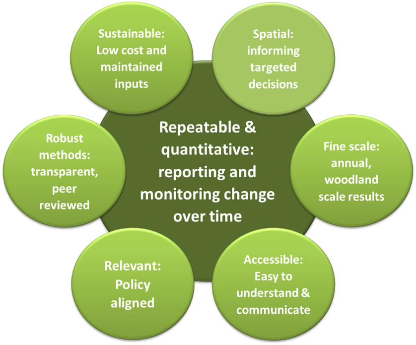
At the outset of the project, the essential qualities of a biodiversity index suitable for public forest agency decision-making were carefully defined. A primary requirement was the ability to assess changes in biodiversity potential over time, supporting both reporting and long-term monitoring. In addition, the agencies sought outputs that could guide spatially targeted management interventions.
To meet these needs, the FOBI was designed to be spatially explicit, quantitative, and repeatable. It delivers results at a finer spatial and temporal resolution than existing biodiversity indicators derived from sample-based national forest inventories.
Crucially, the index also had to align with policy frameworks and be easily interpretable and communicable, while still capturing the complex, multi-dimensional nature of biodiversity. Addressing these complex requirements called for a transparent and scientifically robust methodology, underpinned by accurate, cost-effective, and future-proof data sources.
Findings and Recommendations
Measuring and combining the State-FOBI metrics
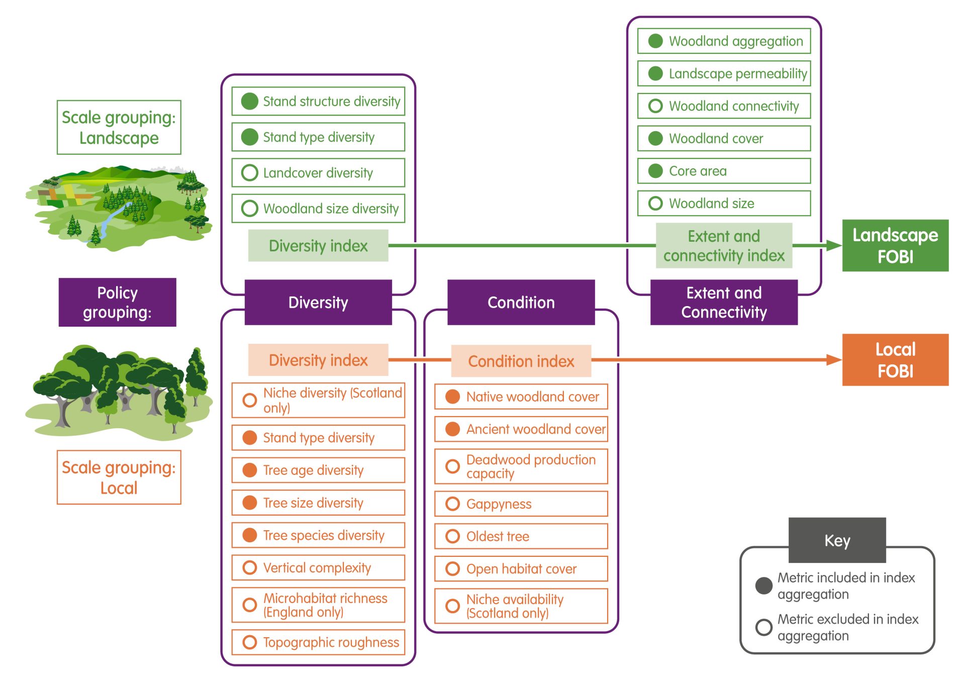
During co-development of the FOBI, several proxies of woodland biodiversity were identified using expert knowledge and the scientific literature. These ‘metrics’ characterise the trees and structures within woodlands, and features of the landscapes surrounding them, such as tree age diversity, open habitat cover, and woodland connectivity. Only those metrics which could be calculated on an annual basis using state forest survey data (the ‘sub-compartment database’) and other spatial-environmental data were taken forward for inclusion.
To encourage the use and communication of the results, the metrics are combined to provide headline measures of biodiversity potential. The FOBI expert group iteratively co-developed and refined a stepped approach that groups the metrics by the scale at which they are measured (local, ‘within woodland’ metrics and landscape, ‘surrounding woodland’ metrics) and their theme (diversity, condition, extent, and connectivity). A Local and a Landscape FOBI are provided at the highest level of the FOBI.
As the combination of multiple measures into a ‘composite index’ can be statistically problematic and provide misleading results, only positively correlated metrics are grouped following best practice guidance. Although this reduces the complexity captured, all levels of the FOBI, including the full set of metrics and the resulting composite indices, are provided to end users.
The same outline approach is applied to England and Scotland, however the metrics calculated diverge slightly due to data availability.
The State-FOBI results
The State-FOBI was initially calculated for a single historical year – 2014 in England and 2011 in Scotland – and for the 2019 baseline year. Since 2019, the State-FOBI results are provided on an annual basis by country, enabling changes in forest biodiversity potential to be assessed over time and space. FR, FLS and FE staff can explore all FOBI metric and index scores by country for internal business via:
- The State-FOBI map: a map of each FOBI woodland unit with attributed FOBI metric and composite index scores by year is provided via Geostore and Forester Web. A selection of the local scale metrics is also measured at the resolution of the forest sub–compartment (analogous to a stand) on an annual basis. These aren’t integrated into the FOBI but are made available for other purposes.
- The State-FOBI Tracker: regional and national FOBI summary statistics are made available to explore changes in the biodiversity potential of state-owned forests over time using an online interactive report. An example of this report (minus the interactivity) is provided here for Scotland: FOBI Tracker Report (Scotland).
Latest Update
The FLS State-FOBI StoryMap
Explore our interactive StoryMap for a dynamic, visual walk through the FOBI project and its application to forests in Scotland managed by FLS.
Further information
If you have questions, please get in touch with chloe.bellamy@forestresearch.gov.uk.
More details on the FOBI approach and results of the State-FOBI are provided in an open access journal paper and supplementary material: Bellamy, C.C., Rattey, A., Edwards, C., Kortland, K., Stringer, A., Tew, E., Bathgate, S., Kerecsenyi, N., Moseley, D., Watts, K. and Broome, A., 2024. The forest biodiversity index (FOBI): monitoring forest biodiversity potential over space and time. Environmental Research: Ecology. The State-FOBI metric and index scores for England (2014-2021) described in the journal paper are provided here as a .csv file to allow exploration of the results: England_FOBI_2014_21.
Please view our FOBI User Guide for further information on interpreting the State FOBI map.
Funding for this work is provided by Forestry and Land Scotland, Forestry England and the Forestry Commission – Innovation Strategy research program 5, 2021-2026.
Funding & Partners
This project is co-funded by Forestry and Land Scotland, Forestry England and Forest Research.