Summary
Monitoring plots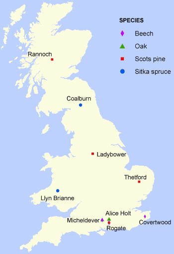
* indicates a Level II forest monitoring plot.
Oak
Beech
Scots pine
Sitka spruce
- Llyn Brianne *
- Coalburn *
Measurements
- Crown condition and forest growth
- Foliar chemistry
- Ground vegetation
- Soil condition
- Atmospheric deposition
- Soil solution chemistry
- Site based meteorology records
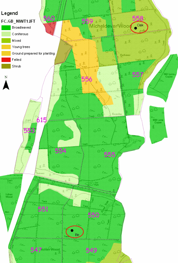
FutMon programme – Micheldever Beech monitoring plot
Map

Description
| Date of installation | April 2009 |
|---|---|
| Planting year | |
| Main tree species | Beech |
| Other tree species present in plot | |
| Forest type | Plantation |
| Silvicultural system | |
| Tree density | |
| Biomass/volume | |
| Basal area | |
| Local yield class | |
| Plot dimensions | 0.1 ha |
| Altitude | 115 |
| Mean slope | 4 degrees |
| Geology | Clay over chalk |
| Topography | Convex |
| Aspect | North |
| Rainfall | |
| Provisional soil type | Clay with flints |
Measurements
Notes:
- (1) Data recorded within the Level II forest monitoring programme
- (2) Data not recorded within the FutMon programme
- (*) Recorded every 2 weeks at Micheldever
- (V) Volume only measured.
| Variables | Period | Frequency of sampling | Rogate Be | Micheldever Be | Covert Wood (1) | Knill Wood (2) |
|---|---|---|---|---|---|---|
| Foliar sampling & analysis | 2005-2007 | Two years | Y | |||
| 2009-2010 | Annual | Y | Y | |||
| Soil analysis | 2010 | Once | Y | Y | ||
| Soil moisture | 2009-2010 | Hourly (*) | Y | Y | ||
| Soil temp | 2009 | Hourly | Y | |||
| 2010 | Hourly(*) | Y | Y | |||
| Stand Precipitation | 2009-2010 | 2 weeks | Y | Y | ||
| Atmospheric deposition | 2002-2010 | 4 weeks | Y | Y | (V) | |
| Permanent girth bands | 2009-2010 | 4 weeks | Y | Y | Y | |
| Phenology (manual recording) | 2009-2010 | Weekly (spring & Autumn) |
Y | Y | Y | |
| Crown condition | 2002-2006 | Annual | Y | |||
| 2009-2010 | Annual | Y | Y | |||
| Leaf area index | 2009-2010 | Once | Y | Y | ||
| Meteorology | 2003-2005 | Continuous (Automatic) | Y | |||
| 2009-2010 | Continuous (Automatic) | Y | Y | |||
| Ground vegetation | 2004-2007 | 3 years | Y | |||
| 2010 | Once | Y | Y | |||
| Ground vegetation analysis | 2010 | Once | Y | Y | ||
| Litter fall quantification | 2002-2008 | 4 weeks (2 weeks Autumn) |
Y | |||
| 2009-2010 | 4 weeks (2 weeks Autumn) |
Y | Y | Y | Y | |
| Litter fall analysis | 2009-2010 | Once | Y | Y | Y |
FutMon programme – Micheldever Oak monitoring plot
Map
Description
| Date of installation | April 2009 |
|---|---|
| Planting year | 1928 |
| Main tree species | Oak |
| Other tree species present in plot | Beech |
| Forest type | Plantation |
| Silvicultural system | |
| Tree density | |
| Biomass/volume | |
| Basal area | |
| Local yield class | |
| Plot dimensions | 0.1 ha |
| Altitude | 105 m |
| Mean slope | 0 |
| Geology | Clay over chalk |
| Topography | 0 |
| Aspect | |
| Rainfall | |
| Provisional soil type | Clay with flints |
Measurements
Notes:
- (1) Data recorded within the Level II forest monitoring programme
- (2) Data not recorded within the FutMon programme
- (*) Recorded every 2 weeks at Micheldever
| Variables | Period | Frequency of sampling | Grizedale (1) | A/H Straits | Savernake (1) | Ardtornish (1) | Micheldever Oak | Craigie wood (2) |
|---|---|---|---|---|---|---|---|---|
| Foliar sampling & analysis | 1995-2005 | Every 2 | Y | Y | Y | |||
| 2005 | Annual | Y | Y | Y | ||||
| 2006 | Annual | Y | ||||||
| 2007-2008 | Annual | Y | ||||||
| 2009-2010 | Annual | Y | Y | |||||
| Soil analysis | 1995 | Once | Y | Y | Y | |||
| 2010 | Once | Y | Y | |||||
| Soil solution | 1995-2001 | 2 weeks | Y | Y | Y | |||
| 2001-2006 | 2 weeks | Y | Y | Y | ||||
| 2007-2010 | 4 weeks | Y | Y | Y | ||||
| Soil moisture | 2007-2008 | Hourly | Y | |||||
| 2009-2010 | Hourly (*) | Y | Y | Y | ||||
| Soil temp | 2009-2010 | Hourly(*) | Y | Y | ||||
| Stand Precipitation | 2009-2010 | 2 weeks | Y | Y | ||||
| Atmospheric deposition | 1995-1996 | 2 weeks | Y | Y | Y | |||
| 1997-2002 | 4 weeks | Y | Y | Y | ||||
| 2002-2006 | 4 weeks | Y | Y | Y | V | |||
| 2007-2008 | 4 weeks | Y | Y | |||||
| 2009-2010 | 4 weeks | Y | Y | Y | ||||
| Leaf area index | 2009-2010 | Once | Y | Y | ||||
| Increment | 1995-6 | 5 yrs | Y | Y | Y | |||
| 2004 | Once | Y | Y | Y | Y | |||
| 2008 | Annual | Y | ||||||
| 2009-2010 | Annual | Y | Y | Y | ||||
| Permanent girth bands | 2008 | Monthly | Y | Y | ||||
| 2009-2010 | Monthly | Y | Y | Y | Y | |||
| Phenology (manual recording) |
1995-2007 | Fortnightly | Y | Y | Y | |||
| 2007-2009 | Monthly | Y | Y | |||||
| 2009-2010 | Weekly (spring & autumn) |
Y | Y | Y | Y | |||
| Phenology (webcam) |
2009-2010 | Hourly | Y | |||||
| Crown condition | 1994-2007 | Annual | Y | Y | Y | Y | ||
| 2009-2010 | Annual | Y | Y | Y | ||||
| Meteorology | 1994-2009 | Manual | Y | Y | ||||
| 1994-2008 | Automatic Met station | Y | ||||||
| 2009-2010 | Automatic Met station | Y | Y | Y | ||||
| Ground vegetation | 1998-2004 | Every 3 years | Y | Y | Y | Y | ||
| 2003-2004 | Annual | Y | ||||||
| 2004-2009 | Every 3 years | Y | Y | |||||
| 2010 | Once | Y | Y | Y | ||||
| Vegetation quantitative | 2010 | Once | Y | Y | Y | |||
| Litter fall quantification | 1998-2002 | 2 weeks (autumn) 4 weeks (winter-summer) |
Y | Y | ||||
| 2002-2008 | 2 weeks (autumn) 4 weeks (winter-summer) |
Y | Y | Y | ||||
| 2009-2010 | 2 weeks (autumn) 4 weeks (winter-summer) |
Y | Y | Y | Y | |||
| Litter fall analysis | 2009-2010 | Once | Y | Y | Y |
FutMon programme – Rogate Beech monitoring plot
Map
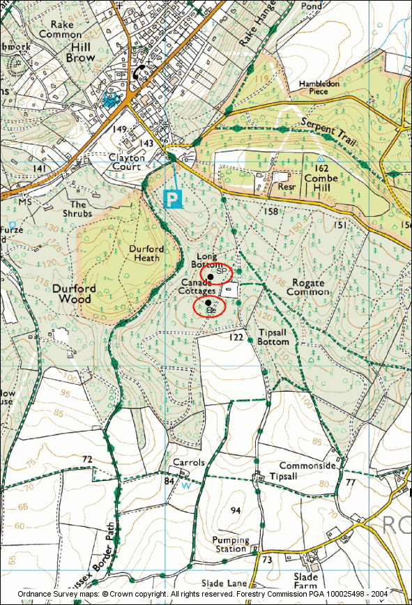
Description
| Date of installation | April 2009 |
|---|---|
| Planting year | 1956 |
| Main tree species | Beech |
| Other tree species present in plot | Oak Birch |
| Forest type | Plantation |
| Silvicultural system | |
| Tree density | |
| Biomass/volume | |
| Basal area | |
| Local yield class | |
| Plot dimensions | 0.1 ha |
| Altitude | 130 |
| Mean slope | 4 |
| Geology | Greensand |
| Topography | Convex |
| Aspect | SW |
| Rainfall | |
| Provisional soil type | Brown earth |
Measurements
Notes:
- (1) Data recorded within the Level II forest monitoring programme
- (2) Data not recorded within the FutMon programme
- (*) Recorded every 2 weeks at Micheldever
- (V) Volume only measured.
| Variables | Period | Frequency of sampling | Rogate Be | Micheldever Be | Covert Wood (1) | Knill Wood (2) |
|---|---|---|---|---|---|---|
| Foliar sampling & analysis | 2005-2007 | Two years | Y | |||
| 2009-2010 | Annual | Y | Y | |||
| Soil analysis | 2010 | Once | Y | Y | ||
| Soil moisture | 2009-2010 | Hourly (*) | Y | Y | ||
| Soil temp | 2009 | Hourly | Y | |||
| 2010 | Hourly(*) | Y | Y | |||
| Stand Precipitation | 2009-2010 | 2 weeks | Y | Y | ||
| Atmospheric deposition | 2002-2010 | 4 weeks | Y | Y | (V) | |
| Permanent girth bands | 2009-2010 | 4 weeks | Y | Y | Y | |
| Phenology (manual recording) | 2009-2010 | Weekly (spring & Autumn) |
Y | Y | Y | |
| Crown condition | 2002-2006 | Annual | Y | |||
| 2009-2010 | Annual | Y | Y | |||
| Leaf area index | 2009-2010 | Once | Y | Y | ||
| Meteorology | 2003-2005 | Continuous (Automatic) | Y | |||
| 2009-2010 | Continuous (Automatic) | Y | Y | |||
| Ground vegetation | 2004-2007 | 3 years | Y | |||
| 2010 | Once | Y | Y | |||
| Ground vegetation analysis | 2010 | Once | Y | Y | ||
| Litter fall quantification | 2002-2008 | 4 weeks (2 weeks Autumn) |
Y | |||
| 2009-2010 | 4 weeks (2 weeks Autumn) |
Y | Y | Y | Y | |
| Litter fall analysis | 2009-2010 | Once | Y | Y | Y |
FutMon programme – Rogate Scots pine monitoring plot
Map

Description
| Date of installation | April 2009 |
|---|---|
| Planting year | 1950 |
| Main tree species | Scots Pine |
| Other tree species present in plot | |
| Forest type | Plantation |
| Silvicultural system | |
| Tree density | |
| Biomass/volume | |
| Basal area | |
| Local Yield Class | |
| Plot dimensions | 0.1 ha |
| Altitude | 115 |
| Mean slope | 1 |
| Geology | Greensand |
| Topography | Flat |
| Aspect | W |
| Rainfall | |
| Provisional soil type | Podzolized brown earth |
Measurements
Notes:
- (1) Data recorded within the Level II forest monitoring programme
| Variables | Period | Frequency of sampling | Rannoch (1) | Thetford (1) | Lady Bower (1) | Rogate SP |
|---|---|---|---|---|---|---|
| Foliar sampling and analysis | 1995-2004 | 2 years | Y | Y | Y | |
| 2005-2006 | Annual | Y | Y | Y | ||
| 2007 | Annual | Y | Y | |||
| 2008 | Annual | Y | Y | Y | ||
| 2009-2010 | Annual | Y | Y | Y | Y | |
| Soil analysis | 1995 | Once | Y | Y | Y | |
| 2010 | Once | Y | ||||
| Increment | 1995-2010 | 5 yrs | Y | Y | Y | |
| 2010 | Annual | Y | Y | Y | Y | |
| Permanent girth bands | 2009 | 2 weeks | Y | |||
| 2010 | 2 weeks | Y | Y | |||
| Crown condition | 1994-2007 | Annual | Y | Y | Y | |
| 2009-2010 | Annual | Y | Y | Y | Y | |
| Meteorology | 1994-2009 | Manual (daily) | Y | |||
| 1994-2005 | Automatic Met station | Y | Y | Y | ||
| 2005-2009 | Automatic Met station | Y | Y | |||
| 2009-2010 | Automatic Met station | Y | Y | Y | Y | |
| Atmospheric deposition | 1995-1996 | 2 weeks | Y | Y | Y | |
| 1996-2006 | 4 weeks | Y | Y | Y | ||
| 2007 | 4 weeks | Y | Y | |||
| 2008 | 4 weeks | Y | Y | Y | ||
| 2009-2010 | 4 weeks | Y | Y | Y | Y | |
| Ground vegetation | 1998-2004 | 3 years | Y | Y | Y | |
| 2007 | Once | Y | ||||
| 2010 | Once | Y | Y | Y | Y | |
| Ground vegetation qualitative | 2010 | Once | Y | Y | ||
| Litter fall quantification | 2001-2006 | 4 weeks | Y | Y | Y | |
| 2007 | 4 weeks | Y | Y | |||
| 2008 | 4 weeks | Y | Y | Y | ||
| 2009-2010 | 4 weeks | Y | Y | Y | Y | |
| Soil solution | 1996-2001 | 2 weeks | Y | Y | ||
| 2002-2006 | 2 weeks | Y | Y | Y | ||
| 2007 | 4 weeks | Y | Y | |||
| 2008 | 4 weeks | Y | Y | Y | ||
| 2009-2010 | 4 weeks | Y | Y | Y | Y |