Summary
Summary
The changing climate is a challenge for forest planning and forest management in England because the projected increases in temperature, changes in the seasonality of rainfall, and an increased frequency of extreme events add complexity to species selection and silvicultural practice. By actively adjusting (adapting) forest management now, to anticipate future changes, we can hope to increase resilience by reducing exposure to risks in the forest industry and in the goods and services that forests provide for society.
Tree productivity will increase in some areas and decline in others, and the effects will vary with species. Some relatively less known species will become more suitable – some from other continents and current climates more similar to those projected for England.
New approaches to woodland management will be required to address the threats of drought and increased risk of damage from pests, pathogens, wind and fire.
There are many uncertainties associated with climate change, and the likely impact on trees, silviculture and forest operations. This uncertainty should not prevent adaptation but instead should direct woodland managers to implement measures that increase resilience whatever climate change brings, or that are likely to reap the greatest rewards in the future.
A key concept in managing risk is diversification: from broadening the choice of genetic material and mixing tree species in different ways, to varying management systems and the timing of operations.
About the information provided
Information has been compiled from information in the Read Report (Read et al., 2009), knowledge within the forest scientific community, and from tree species suitability modelling using the decision-support tool Ecological Site Classification (ESC). The work applies future climate emissions’ scenario projections through ESC climate and site factors to examine likely changes in tree species suitability.
Maps are indicative and use coarse-resolution soil information with future climate variables derived from simulations provided by the United Kingdom Climate Impacts Programme (2002) (UKCIP02) at 5 km resolution. It is very important that the maps are used only to infer trends, and that forest planning for the future climate involves careful site-based and stand-based consideration.
Publications and reports
- Climate change: impacts and adaptation in England’s woodlands
By D. Ray, J. Morison and M. Broadmeadow.
Forestry Commission Research Note 201. - Combating Climate Change – A Role for UK Forests
The first National Assessment of Forestry and Climate Change. Report provides peer-reviewed information at the national level following on from the recommendations from the global evaluation provided by the Intergovernmental Panel on Climate Change (IPCC).
Prepared by a panel of authors chaired by Professor Sir David Read, Emeritus Professor of Plant Sciences at the University of Sheffield, and which included Forest Research scientists. The report is published by TSO (The Station Office). - Climate change and the future for broadleaved tree species in Britain
By M. Broadmeadow, D. Ray and C. Samuel.
Forestry 78:145-167. - Climate Change and British Woodland (PDF-2872K)
By M. Broadmeadow and D. Ray.
Forestry Commission Information Note 69. - Climate change: Impact on UK Forests
Describes current thinking on the most likely effects of climate change on UK forests and woodlands. It is recommended reading for forest managers and advisers, students and all those with an interest in the consequences of global change to our forests.
Forestry Commission Bulletin 125.
Contact
For further information contact:
Funders and partners
![]()
![]()
This research is funded by the Forestry Commission Climate Change programme and Forestry Commission England.
Forestry Commission policy
Forestry Commission’s approach to climate change is set out in the UKFS Forests and Climate Change Guidelines. Forestry sector actions that contribute to the UK policy on climate change mitigation are set out in the 2011 UK Carbon Plan and in the UK’s 2015 LULUCF Action Report to the European Commission. Although actions to adapt to climate change are the responsibility of individual countries of the UK (e.g. for England, the National Adaptation Programme) they follow a common framework for assessing risk as set out in the 2012 UK Climate Change Risk Assessment, which will be revised in 2017.
An overarching aim of forestry is to ensure that woodlands are resilient to the impacts of climate change and pests and diseases and are able to contribute to the way in which society, biodiversity and natural resources adjust to a changing climate. Such adaptation is also necessary to ensure that forestry can continue to make its important contribution to a future low carbon society through active management providing woodfuel and timber products.
Adapting England’s forests to climate change – UKCP09
What is UKCP09?
The name refers to the UK climate projections published in June 2009 by the United Climate Impacts Programme (UKCIP) and Defra. The projections included probability estimates of the likelihood of certain changes in the climate happening by a certain decade.
The UKCP09 website has been archived, both at the National Archives and at the CEDA Archive Dataset Collection.
Within the interface users were easily able to develop maps and graphs showing the degree of change likely in different parts of the UK. Graphic information about climatic variables such as rainfall and temperature was easily assembled for months, seasons, years, and for different decades into the century.
Example outputs
4 examples of change by 2050 compared to the baseline climate (1961-1990) for the Medium emissions’ scenario median likelihood, are shown below:
- Change in winter rainfall in England by 2050 (PDF-249K)
- Change in summer rainfall in England by 2050 (PDF-249K)
- Change in winter mean temperature in England by 2050 (PDF-253K)
- Change in summer mean temperature in England by 2050 (PDF-253K)
© Crown Copyright 2009. The UK Climate Projections data have been made available by the Department for Environment, Food and Rural Affairs (Defra) and Department for Energy and Climate Change (DECC) under licence from the Met Office, Newcastle University, University of East Anglia and Proudman Oceanographic Laboratory. These organisations accept no responsibility for any inaccuracies or omissions in the data, nor for any loss or damage directly or indirectly caused to any person or body by reason of, or arising out of, any use of this data.
Adapting England’s woodland to climate change – main issues
- Current projections suggest that areas of south, central and eastern England will have drier and warmer summers, resulting in increasingly severe soil moisture deficits which will reduce tree growth – particularly on shallow, south facing slopes, and sandy-textured, freely draining soils.
- Drought tolerant species and changes to silvicultural systems should be introduced on sites vulnerable to drought.
- By mixing species within forest areas and by amending silvicultural systems (where appropriate), it should be possible to reduce and spread the risk of climatic impacts on forests.
- Warmer growing seasons and rising CO2 concentrations will stimulate productivity and timber production where soil water and nutrient availability allows. Increases of 2-4 m3 ha-1 yr-1 in upland conifer forests of the north and west of England may result. Improved growth may also occur, initially, in more southerly regions, although species will need to be matched carefully to site conditions.
- Changes in the seasonality of rainfall have occurred gradually over the past century, and this trend is projected to continue and to intensify in the future. The resulting wetter autumn and winter periods will cause greater water table fluctuations, limit rooting depth, and reduce tree stability on exposed sites.
- Changes in the wind climate are highly uncertain but, with reduced anchorage on wet sites, the risk of windthrow will increase.
- The incidence and severity of tree disease and pest outbreaks will increase. A warmer climate and, particularly, warmer winters will allow tree pests and pathogens to extend their range.
- Climate change presents new opportunities for the forestry sector, particularly the planting of new woodlands to sequester carbon and provide wood fibre and timber products for future generations; but these new woodlands must also be resilient to the impacts of climate change.
Adapting England’s woodland to reduce abiotic and biotic impacts from climate change
Summary of the main impacts of climate change and potential adaptation strategies in England’s woodlands and forests, identified through expert panel discussions and the synthesis of peer reviewed work.
Note: read across rows of the tables for example citations to support the factors and relationships between impacts and adaptation. Full references are provided following the tables.
Species suitability, growth, and abiotic impacts
| Factor | Impact | Adaptation measure | Some supporting citations |
|---|---|---|---|
| Longer growing season1 | Earlier bud burst, later bud set, more lammas growth2 | Select material up 2o latitude south of site3, and up to 5o south as a small component of mixed provenance stock in species of low frost sensitivity | (Jenkins, Perry & Prior, 2007)1,(Hulme et al., 2002)1, (Broadmeadow & Ray, 2005)2, (Hubert & Cottrell, 2007)3 |
| Warmer growing season1 increased CO2 concentration2 | Increased growth rates3, improved yield (2-4 m3 ha-1an-1 increase for conifers | Choose conifer and broadleaf species that will produce better quality timber grown in a warmer climate, but beware of frost sensitive species on frost prone sites | (Jenkins, Perry & Prior, 2007)1,(Hulme et al., 2002)1,2,(Cannell, 2002)3,(Briceno-Elizondo et al., 2006)3 (Hasenauer et al., 1999)3 (Proe, Allison & Matthews, 1996)3, (Ray, Pyatt & Broadmeadow, 2002)4, (Broadmeadow & Ray, 2005)1,2, (Broadmeadow, Ray & Samuel, 2005)4 |
| Fewer frost days – milder winters1 | Reduced hardening, later dormancy, increased risk of autumn frost damage to sensitive species with extended growing season 2 | Change to less frost sensitive species/provenances; change to species requiring less cold to harden, and increase genetic diversity 3 | (Jenkins, Perry & Prior, 2007)1, (Hulme et al., 2002)1, (Thomas, Blank & Hartmann, 2002)2, (Broadmeadow & Ray, 2005)2, (Broadmeadow, Ray & Samuel, 2005)2, (Hubert & Cottrell, 2007)3 |
| Reduced summer rainfall1 | More frequent and drier summers2, reduced growth3, increased drought stress4, increased fire frequency5 | Change/mix species to drought tolerant types on sensitive sites6. Contingency plan and regular training for fighting fire | (Jenkins, Perry & Prior, 2007)1, (Hulme et al., 2002)1, (Broadmeadow, Ray & Samuel, 2005)2,3,4,5, (Ciais et al., 2005)2,3,4, (Thomas, Blank & Hartmann, 2002)2,3,4, (Green & Ray, 2009)4,6,(Broadmeadow et al., 2009)6 |
| Increased winter rainfall | Increased waterlogging and anaerobiosis2, increased wind damage3, increased soil erosion4 | Shorter rotation, Switch to species tolerant of wet soil on sensitive sites, smaller coupes, self-thinning mixtures, forest operations controls 5 | (Jenkins, Perry & Prior, 2007)1, (Hulme et al., 2002)1, (Nisbet, 2002)2,3,4, (Ray, 2008)5, (Mason, Nicoll & Perks, 2009)5 |
Disturbance, management, and biotic impacts
| Factor | Impact | Adaptation measure | Some supporting citations |
|---|---|---|---|
| Longer growing season1 | More generations of insect pests per year (voltinicity increases)2 | Increase tree species diversity; enhanced monitoring and intervention where possible or appropriate 3 | (Jenkins, Perry & Prior, 2007)1,(Hulme et al., 2002)1, (Jactel & Brockerhoff, 2007)2,3 |
| Milder winters1, warmer growing season2, increased CO2 concentration3 | Increased productivity4, Increase in woodland mammals5, tree invertebrate pests6 and tree diseases7, colonisation of alien invasive species | Increase deer and squirrel management effort; enhanced pest and pathogen monitoring and intervention where appropriate. Mix tree species in forests6 | (Jenkins, Perry & Prior, 2007)1,(Hulme et al., 2002)1,2,3, (Cannell, 2002)4, (Pettorelli et al., 2005)5, (Irvine et al., 2007)5,(Lonsdale & Gibbs, 2002)6, Evans, 2002 #494]7, (Jactel & Brockerhoff, 2007)6, (Green & Ray, 2009) 7 |
| Increased windiness | Increased wind damage1, increased bark beetle damage2 and increase bluestain fungus infection in stands3 | Reduce risk through shorter rotations, species diversification and early thinning, and self-thinning mixtures 4. | (Hulme et al., 2002)1, (Quine & Gardiner, 2002) 1, (Schlyter et al., 2006) 1,2, (Redfern et al., 1987) 2, (Gibbs & Inman, 1991)3, (Broadmeadow, Ray & Samuel, 2005)4, (Mason, Nicoll & Perks, 2009)4 |
| Reduced summer rainfall | Increased fire frequency2, increased drought damage2 and secondary pest/pathogen outbreaks, increased risk of drought damage and secondary infection from drought stress3 | Amend species choice; more thinning to reduce moisture demand in open stands; increase public awareness and control of activity4 | (Hulme et al., 2002)1, (Broadmeadow, Ray & Samuel, 2005)2,(Green & Ray, 2009)3, (Broadmeadow, Ray & Samuel, 2005)4, (Lawrence & Carter, 2009)4, (Handley & Gill, 2009)4 |
| Increased winter rainfall1 | Anaerobic stress; increased Phytophthora infection2; endemic windthrow due to waterlogging3; slope failure4 | Change/mix to tolerant species3; self-thinning mixtures3; shorten rotation length; change silvicultural system on steep slopes | (Jenkins, Perry & Prior, 2007)1,(Hulme et al., 2002)1, (Thomas, Blank & Hartmann, 2002) 2, (Broadmeadow, Ray & Samuel, 2005)3, (Mason, Nicoll & Perks, 2009)4 |
References
Briceno-Elizondo, E., Garcia-Gonzalo, J., Peltola, H., Matala, J. & Kellomaki, S. (2006). Sensitivity of growth of Scots pine, Norway spruce and silver birch to climate change and forest management in boreal conditions. Forest Ecology and Management, 232, 152-67.
Broadmeadow, M. & Ray, D. (2005). Climate change and British Woodland Forestry Commission, Edinburgh.
Broadmeadow, M., Ray, D. & Samuel, C. (2005). Climate change and the future for broadleaved tree species in Britain. Forestry, 78(2), 145-67.
Broadmeadow, M., Webber, J., Ray, D. & Berry, P. (2009). An assessment of likely future impacts of climate change on UK forests. In Combating climate change – a role for UK forests. An assessment of the potential of the UK’s trees and woodlands to mitigate and adapt to climate change (ed F.-S.P. Read DJ, Morison JIL, Hanley N, West CC, Snowdon P). The Stationery Office, Edinburgh.
Cannell, M. (2002). Impacts of Climate Change on forest growth. In Climate Change: Impacts on UK Forests, Forestry Commission Bulletin 125 (ed M.S.J. Broadmeadow). Forestry Commission, Edinburgh.
Ciais, P., Reichstein, M., Viovy, N., Granier, A., Oge´e, J., Allard, V., Aubinet, M., Buchmann, N., Bernhofer, C., Carrara, A., Chevallier, F., Noblet, N.D., Friend, A., Friedlingstein, P., Gru¨nwald, T., Heinesch7, B., Keronen, P., Knohl, A., Krinner, G., Loustau, D., Manca, G., Matteucci, G., Miglietta, F., Ourcival, J., Papale, D., Pilegaard, K., Rambal, S., Seufert, G., Suussana, J., Sanz, M., Schulze, E., Vesala, T. & Valentini, R. (2005) Europe-wide reduction in primary productivity caused by the heat and drought in 2003. Nature, 437, 529-33.
Gibbs, J.N. & Inman, A. (1991). The pine shoot beetle Tomicus piniperda as a vector of blue stain fungi to windblown pine. Forestry, 64, 239-49.
Green, S. & Ray, D. (2009). Potential impacts of drought and disease on forestry in Scotland Forestry Commission Edinburgh.
Handley, N. & Gill, S. (2009). Woodlands helping society to adapt. In Combating climate change – a role for UK forests. An assessment of the potential of the UK’s trees and woodlands to mitigate and adapt to climate change (ed F.-S.P. Read DJ, Morison JIL, Hanley N, West CC, Snowdon P). The Stationery Office, Edinburgh.
Hasenauer, H., Nemani, R., Schadauer, K. & Running, S. (1999). Forest growth response to changing climate between 1961 and 1990 in Austria. Forest Ecology and Management, 122, 209-19.
Hubert, J. & Cottrell, J. (2007). The role of forest genetic resources in helping British forests respond to climate change Information Note 86, Forestry Commission, Edinburgh, UK.
Hulme, M., Jenkins, G.J., Lu, X., Turnpenny, J.R., Mitchell, T.D., Jones, R.G., Lowe, J., Murphy, J.M., Hassell, D., Boorman, P., MacDonald, R. & Hill, S. (2002). Climate Change Scenarios for the United Kingdom: The UKCIP02 Scientific Report. In, p 120. Tyndall Centre for Climate Change Research, School of Environmental Science, University of East Anglia, Norwich, UK.
Irvine, R.J., Broadmeadow, M., Gill, R.M.A. & Albon, S.D. (2007). Deer and global warming. Deer Magazine, Autumn.
Jactel, H. & Brockerhoff, E.G. (2007). Tree diversity reduces herbivory by forest insects. Ecology Letters, 10(9), 835-48.
Jenkins, G.J., Perry, M.C. & Prior, M.J.O. (2007). The climate of the United Kingdom and recent trends Met Office Hadley Centre, Exeter, UK.
Lawrence, A. & Carter, C. (2009). Human behavioural and institutional change. In Combating climate change – a role for UK forests. An assessment of the potential of the UK’s trees and woodlands to mitigate and adapt to climate change (ed F.-S.P. Read DJ, Morison JIL, Hanley N, West CC, Snowdon P). The Stationery Office, Edinburgh.
Lonsdale, D. & Gibbs, J. (2002). Effects of climate change on fungal diseases of trees. In Climata Change: Impacts on UK Forests (ed M. Broadmeadow). Bulletin 125, Forestry Commission, Edinburgh.
Mason, W.L., Nicoll, B.C. & Perks, M.P. (2009). Mitigation potential of sustainably managed forests. In Combating climate change – a role for UK forests. An assessment of the potential of the UK’s trees and woodlands to mitigate and adapt to climate change (ed F.-S.P. Read DJ, Morison JIL, Hanley N, West CC, Snowdon P). The Stationery Office, Edinburgh.
Nisbet, T.R. (2002). Implications of Climate Change: Soil and Water. In Climate Change: Impacts on UK Forests, Forestry Commission Bulletin 125 (ed M.S.J. Broadmeadow). Forestry Commission, Edinburgh.
Pettorelli, N., Mysterud, A., Yoccoz, N.G., Langvatn, R. & Stenseth, N.C. (2005). Importance of climatological downscaling and plant phenology for red deer in heterogeneous landscapes. Proceedings of the Royal Society B, 272, 2357-64.
Proe, M., Allison, S. & Matthews, K. (1996). Assessment of the impact of climate change on the growth of Sitka spruce in Scotland. Canadian Journal of Forest Research, 26, 1914-21.
Quine, C. & Gardiner, B. (2002). Climate Change Impacts: Storms. In Climate Change: Impacts on UK Forests, Forestry Commission Bulletin 125 (ed M.S.J. Broadmeadow). Forestry Commission, Edinburgh.
Ray, D. (2008). Impacts of climate change on forestry in Wales Forestry Commission Wales Research Note 301, Aberystwyth.
Ray, D., Pyatt, G. & Broadmeadow, M. (2002). Modelling the future climatic suitability of plantation forest tree species. In Climate Change: Impacts on UK Forests, Forestry Commission Bulletin 125 (ed M. Broadmeadow). Forestry Commission, Edinburgh.
Redfern, D., T, S.J., H, S. & W, M.D. (1987). Dieback and health of larch caused by Ceratocystis laricicola sp. following attack by Ips cembrae. Plant Pathology, 36, 467-80.
Schlyter, P., Stjernquist, I., Barrlnq, L., Jonsson, A.M. & Nilsson, C. (2006). Assessment of the impacts of climate change and weather extremes on boreal forests in northern Europe, focusing on Norway spruce. Climate Research, 31, 75-84.
Thomas, F.M., Blank, R. & Hartmann, G. (2002). Abiotic and biotic factors and their interactions as causes of oak decline in Central Europe. Forest Pathology, 32, 277-307.
Assessment of drought risk in eastern central and southern England
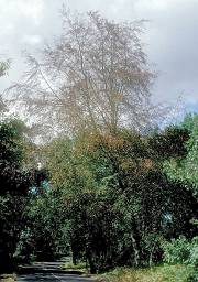
Drought damaged beech (Fagus sylvatica) following the dry summer of 1990. Location: Rowledge, Surrey, England. Photographer: George Gate.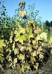
Drought damage (1990) to sycamore (Acer pseudoplatanus) plants in their second growing season on a sandy ex Nursery site. Location: Rogate Old Nursery, Hampshire, England. Photographer: Robert Strouts.
Introduction
To assess the potential effect of dry summers on species suitability, information about the interactions between tree species, climate change, sites and soil properties is necessary at a detailed local level.
However the national digital soil data (NATMAP) from the Soil Survey of England and Wales (SSEW) published by the National Soil Resources Institute (Cranfield University) is not sufficiently detailed to allow an assessment of climate change on forest soils at a site or stand-level.
Considering that some of the abiotic impacts on forests are likely to be caused by drier summers and wetter winters, a primary source of climatic information are maps showing the projected change in seasonal (summer and winter) rainfall in the future, mapped at a resolution of 25 km in the UK climate projections (UKCP09: Murphy et al., 2009), and accessible on the UK Climate Impacts Programme (UKCIP) web pages.
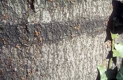 The orange tendrils (Conidia) of the fungus (Libertella faginea) on dead bark of beech (Fagus sylvatica) killed by the 1976 drought. This fungus is a common invader of drought damaged beech and could well have been involved in the death of the bark. Location: Windsor, Berkshire, England. Photographer: Robert Strouts.
Assessing drought risk
We have developed a system to help forestry practitioners understand the interactions between climate, soil and site type and the impact the combination may have on tree species suitability.
A knowledge-base has been developed for forest soils, for use in the drier eastern, central and southern parts of England. We have been able to access a small sample of high resolution ‘paper’ soil maps, e.g. at a scale of 1:50k, to provide information on forest soils. The maps have been used in an analysis to identify the soil series (and Forestry Commission (FC) soil type equivalent) on which woodlands occur.
The areal extent of each forest soil has been estimated separately for a series of 25×25 km resolution squares, defined by UKCIP as a basis for the spatial projection of climate by UKCP09. For each numbered 25×25 km square (see map below), we have assembled a table of the 3 main forest soils, ranked 1-3 by area showing the series name and the equivalent FC soil type code.
Information in SSEW bulletins has provided a method for assessing the drought sensitivity of each soil series and, when combined with future changes in summer seasonal rainfall from UKCP09, an estimate of the risk of future drought in woodlands on that type of soil.
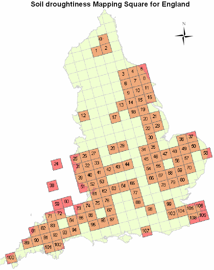
To follow – a table showing the most frequent forest soil types (Soil Series name and FC soil type equivalent) and their drought sensitivity is currently being finalised, and will be available soon. The table will provide an indication of the sensitivity of woodland to future droughts in that square.
Monitoring climate change
A number of forest monitoring networks exist in the UK for which Forest Research is either the national co-ordinator or is a key contributor. These networks are being used partly to monitor how climate change may be affecting the nation’s woodlands.
Monitoring networks
- EU Life+ FutMon (formerly Intensive forest health monitoring EU/ICP-Forests Level II network)
- Permanent mensuration sample plot network (PSP)
- Forest condition monitoring EU/ICP-Forests Level I network (L-I)
- UK forest condition survey network (FCS)
- National inventory of woodlands and trees (NIWT), now National Forest Inventory (NFI)
- Environmental Change Network (ECN).
EU Life+ FutMon (Formerly – Intensive forest health monitoring EU/ICP-Forests Level II network)
The network for intensive monitoring on permanent observation plots was established in 1994. Currently there are approximately 900 plots across Europe, although the intensity of measurements varies from plot to plot. In the UK, ten sites were established in 1995 (oak, Sitka spruce and Scots pine), with a further ten added in 2002 (beech and Norway spruce) to represent more species and regions within the UK
Stand height, diameter and volume increment, foliar chemistry, soil chemistry, crown condition and ground vegetation are assessed at all sites, while litter, air quality, meteorology and soil water chemistry are assessed at a proportion of the sites.
Permanent mensuration sample plot network (PSP)
The first permanent mensuration sample plots were established before 1920, with the aim of providing data on which to base yield models for forest management and production forecasting. On the whole PSPs have been established in single species, even-aged stands, and thus are not fully representative of all current forestry practice in the UK. There are currently 509 active plots, representing primarily the major commercial species planted in the UK.
Forest condition monitoring EU/ICP-Forests Level I network (L-I)
The L-I Forest Condition Survey was a Europe-wide assessment of spatial and temporal variation in forest condition using crown density or transparency as the principal indicator. Surveys of crown density have been carried out on an annual basis since 1986 at between 1700 plots (in 1988) and 6000 plots (in 2000) across Europe.
In the UK, there are approximately 90 L-I plots covering five tree species (oak, beech, Scots pine, Sitka spruce, Norway spruce). The protocol requires a minimum plot size of 0.25 ha (although this is not always realised), with the crown density of 24 ‘internal’ plot trees assessed across the four aspects (N, S, E, W). The plots have been established on a 16 × 16 km transnational grid across Europe, enabling pan-European assessments of forest condition to be made.
UK forest condition survey network (FCS)
The FCS was instigated in 1984 prior to the establishment of the L-I network and provides greater spatial representation and more detailed measurements than strictly required for the EU L-I network. As such, the L-I network forms a subset of the FCS network. The same five tree species are assessed (59 beech, 55 Norway spruce, 86 oak, 81 Scots pine, 66 Sitka spruce and 3 mixed broadleaf).
More variables are measured in FCS than are strictly required under the EU L-I protocol. The supplementary measurements include annual assessments of dbh and a single assessment of top height recorded on establishment.
Supplementary tree quality measures assessed on an annual basis –
- Crown form/branch pattern
- Discoloration
- Degree of canopy closure
- Needle retention
- Mechanical damage
- Flowering
- Fruiting
- Insect and pathogen damage.
The forest condition survey was last run in 2006.
National inventory of woodlands and trees (NIWT)
This inventory, otherwise known as the Census of Woodland, is carried out every 10-15 years. The most recent survey was based on a combination of analysis of the 1:25000 OS map and, primarily, interpretation of aerial photography. The NIWT considered woods of more than 2 ha area, although a separate survey of small woods and linear features was also conducted as part of the assessment, but in less detail. A wide range of attributes are recorded, many of which could be interpreted in terms of a changing climate. NIWT has been superseded by the National Forest Inventory (NFI), which ran between 2009 and 2014.
Environmental Change Network (ECN)
The UK Environmental Change Network (ECN) is one of the UK’s long-term, integrated environmental monitoring and research programme. ECN gathers information about the pressures on and responses to environmental change in physical, chemical and biological systems. It is supported by a consortium of fourteen sponsoring organisations and eight research organisations. Forest Research is the responsible for a site managed as productive forest (broad-leaved and coniferous) and located at Alice Holt Forest, Hampshire UK.
ECN’s objectives are:
- To establish and maintain a selected network of sites within the UK from which to obtain comparable long-term datasets through the monitoring of a range of variables identified as being of major environmental importance
- To provide for the integration and analysis of these data, to identify natural and man-induced environmental changes and improve understanding of the causes of change
- To distinguish short-term fluctuations from long-term trends, and predict future changes
- To provide, for research purposes, a range of representative sites with good instrumentation and reliable environmental information.