Summary
Background
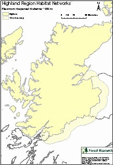
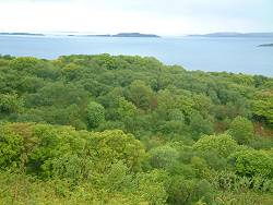
The study area was defined by the Forestry Commission Scotland (FCS), Highland and Islands Conservancy boundary, with a 15 km buffer (see map on right), comprising approximately 3,316,000 ha, of which almost 531,500 ha is woodland. Coniferous woodland dominates, with a sizeable proportion of this comprised of native pinewood, whilst heathland forms the dominant open ground habitat.
Objectives
In the area covered by Highland and Islands Conservancy:
- Identify the key woodland and heathland habitats to enable a Habitat Network analysis to be undertaken
- Determine the extent of Atlantic oakwoods in the region
- Classify woodlands in terms of biodiversity quality
- Develop a tool to assess the contribution of new planting schemes to biodiversity for a locational premium forestry grant scheme.
Methods
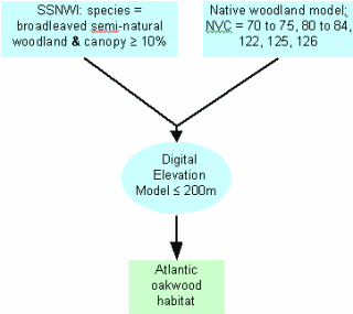
- Areas likely to contain Atlantic oak woodland were determined using a predictive dataset (see figure below) based on the following criteria:
- Semi-natural broadleaved woodland with a minimum of 10% canopy cover from the Scottish Semi-Natural Woodland Inventory (SSNWI)
- Plus areas that intersect the Macaulay Institute's Native Woodland Model National Vegetation Classification categories (70 to 75, 80 to 84, 122, 125, 126)
- Plus areas below an elevation of 200 m, as sites at higher elevation are more likely to tend towards birchwood types.
- A quality assessment of ancient pine woodlands and Atlantic oak woodlands was undertaken by interview with woodland experts.
- The Habitat Network Tool from BEETLE (Biological and Environmental Evaluation Tools for Landscape Ecology) was used to assess habitat network extent for Highland and Islands Conservancy, focusing on three woodland types: Atlantic oakwood; ancient pinewood; all pinewoods, and heathland as an open ground habitat.
- The networks were used within a forestry grant scheme to direct new planting using a decision support tool to assess how new woodland would improve the functional connectivity of existing networks.
- Measures of the potential improvement of functionally connected woodland habitat were used in a formula to calculate the amount of woodland grant for new areas of native woodland.
Results
A Forest Habitat Network for the Atlantic oakwoods in Highland Region, Scotland (PDF-557K)
Forest Habitat Networks Scotland – Highland Conservancy Report (PDF-1610K)
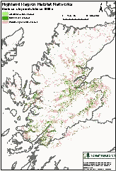
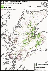
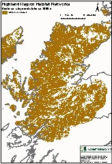
Maps (below) show the potential extent of functional networks can be incorporated into strategic plans for Highland to reduce habitat fragmentation:
- Atlantic oakwood
- Pinewoods
- Heathland
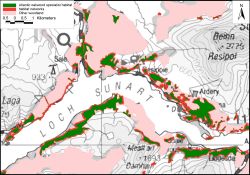
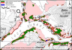
A case study of the Sunart oakwoods indicates how the functional connectivity of these woodlands could be improved with some judicious planting:
Practical implementation of the networks to improve biodiversity was quickly seized upon by the Forestry Commission Highland and Islands Conservancy. In January 2006, the launch of a locational premium scheme was announced with the aim "to achieve a targeted expansion of forest habitat networks in Highland to improve forest diversity and biodiversity and to increase the ability of forest species and habitats to adapt to climatic changes." An additional tool from the BEETLE suite was developed to determine how effectively new planting schemes could improve broadleaved and pinewood network connectivity.
General Content
What's of interest
Improving_forest_habitat_networks.pdf (PDF-421K)
Article from Forestry & British Timber – January 2007