Summary
Current and planned research projects related to this plot
- Dissolved organic carbon in soil solution
- Soil mineral weathering rates
Measurements
A summary of the variables monitored at this site can be found here.
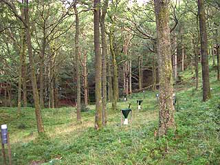
Description
| Date of installation | 06/10/1994 |
|---|---|
| Planting year | 1920 |
| Main tree species | 100 % Sessile oak (Quercus petraea) |
| Other tree species present in plot | Larch, Rowan, Beech, Birch in the vicinity |
| Forest type | Plantation |
| Sylvicultural system | |
| Tree density | 230 trees/ha |
| Biomass/volume | 218 m3/ha (2004) |
| Basal area | 25.2 m2/ha (2004) |
| Local Yield Class | 4 |
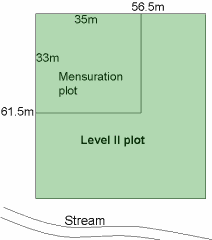
| Plot dimensions | 0.2954 ha |
| Altitude | 110 – 120 m |
| Mean slope | 30 % |
| Geology | |
| Topography | Hilly, valley and valley side |
| Aspect | South West |
| Rainfall | 1770 mm |
| Provisional soil type (FAO 1988) | Cambic podzol |
Surrounding habitat
Management history
Pre-20th century
- Grizedale forest has always been a largely wooded tract of country, which was mainly used for pannage until 1537.
- Primeval oak, birch, holly, alder had been felled before 1537 (Forestry Commission, 1951b).
- From 1537 it was coppice woodland, though the exact species are unknown. Hall wood and Scale Green are remnants.
- Iron smelting by charcoal and gunpowder. Management of woods related to demand (Forestry Commission, 1951b).
- 1851: Old map indicates broadleaf woodland (Landmark Information Group, 2004), possibly coppice or old oak wood with a scattering of birch (pers.comm. Durrant, 1994).
20th century
- 1913: Old map indicates possible sparse woodland/grazing.
- 1914-18: Woodland felled (Forestry Commission, 1951b).
- Pre-1937: Woodland owned and administered by the Monks of Furness Abbey – mainly used for the grazing of pigs and production of a small amount of housing timber (Forestry Commission, 1951b).
- In 1937 there were five types of land use in Grizedale (Forestry Commission, 1951b):<
- Agricultural land in the valley bottoms
- Badly managed/derelict old coppice on lower hill slopes (due to the location, the Level II site probably fits into this category)
- Scattered plantations of 50- to 75-year-old European larch (max. 65 acres) grazed by sheep
- Bare, rocky or heather covered knolls used for grazing
- Small areas of badly managed young conifer stands.
- Planted 01/01/1920 with sessile oak (pers.comm. Durrant, 1994).
- 1920 to 1994: Heavily thinned at some point, date unknown.
- 1994: 78 oak trees over 2954 m2 (pers.comm. Durrant, 1994).
- 1994: Oaks standing at final crop with a few older oaks throughout the area.
- 1994: Thinning – small hardwood and dead trees removed (06/10/94 – trees 7, 22 and 23 removed).
- 1995: (27th September): Trees 6, 8, 9, 21, 109, 112, 116, 119, 121, 129 and 134 removed. Thinned to fit in with district plans to thin all the oak in the valley and to create “glades” to encourage natural regeneration. (pers.comm. Durrant, 1994).
- A notable deterioration in mean tree crown density from 72% in 1995 to 45% in 2005 observed in oak trees at the Grizedale Level II site. The decline in density is associated with severe defoliation by Tortrix caterpillars.
21st century
- 2004 to 2005: Plot thinned.
References
Forestry Commission. (1951b). History of Grizedale Forest.
Landmark Information Group. (2004). See www.old-maps.co.uk